METAR & TAF KRCX
Current METAR
Observed 18:35Z
KRCX 271835Z AUTO 31010G17KT 10SM SCT038 SCT044 32/22 A2970 RMK AO2 T03150219
- Wind
- 310° @ 10G17 kt
- Visibility
- 10 SM
- Temp / Dew
- 32°C / 22°C
- Altimeter
- 29.70 inHg
- Clouds
- SCT
- Density alt
- 3,850 ft
- Ceiling
- Unlimited
- Rules
- VFR
Airport info & contacts
Manager on record, flight service, ARTCC, attendance schedule and pattern altitude — published by the FAA and refreshed every 28 days.
Location
- From city
- 4 NM NE
- VFR sectional
- GREEN BAY
- ARTCC
- ZMP · MINNEAPOLIS
- NOTAM facility
- RCX (NOTAM-D)
Airport manager
- Name
- BRETT EWER
- Phone
- 715-532-2137
- Address
- 311 MINER AVE E, LADYSMITH WI 54848
Flight service · Hours
- FSS GRB
- GREEN BAY1-800-WX-BRIEF
- Attendance
- IREG
Frequencies
Tap any row to copy the frequency to your clipboard.
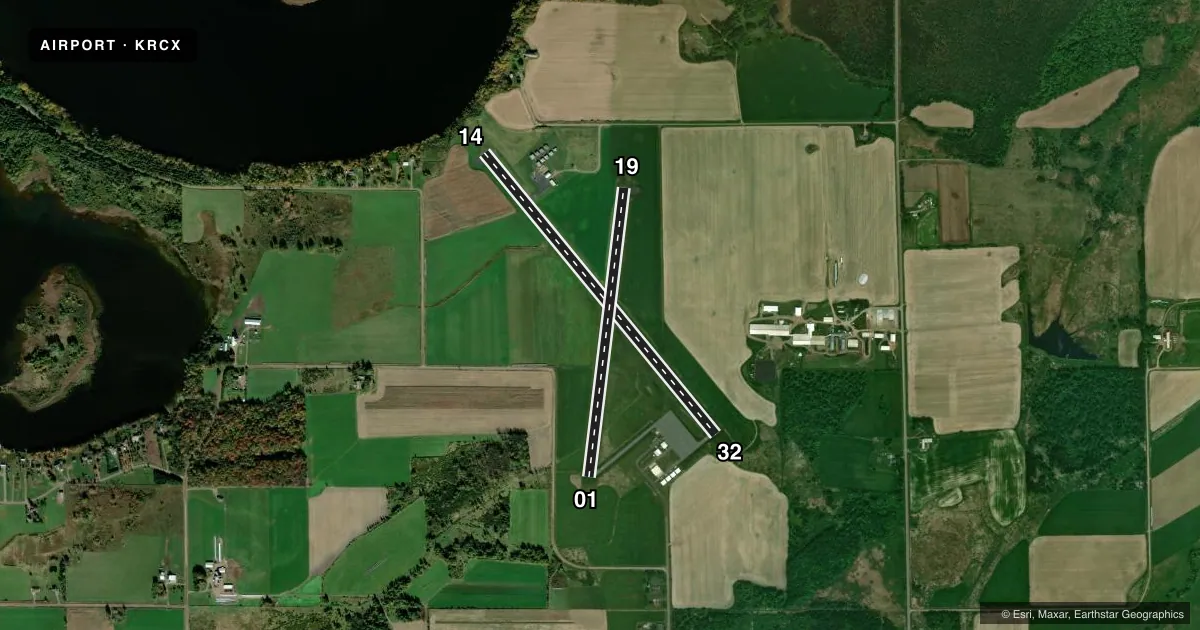
Runways & pattern
Full pagePattern entry · RWY 32
LEFT TRAFFIC| Runway | Heading (°M) | Length | Surface | Traffic |
|---|---|---|---|---|
| 14/32Favored | 140° / 320° | 4,001 ft | ASPH | Standard L |
| 01/19 | 7° / 187° | 3,199 ft | ASPH | Standard L |
Runway end performance
| End | TORA | TODA | ASDA | LDA | VGSI | Approach lights | Obstruction |
|---|---|---|---|---|---|---|---|
| 14 | — | — | — | — | PAPI 2-box left(3°) | — | — |
| 32 | — | — | — | — | PAPI 2-box left(3°) | — | 83', trees, 1620' from thr, 270' R of cntrln, slope 17 |
| 19 | — | — | — | — | — | — | 100', trees, 2030' from thr, 305' R of cntrln, slope 18 |
Declared distances in feet. TORA = takeoff run available, TODA = takeoff distance, ASDA = accelerate-stop, LDA = landing distance.
Airport sketch
Runways drawn to scale from FAA survey coordinates, rendered over satellite imagery. Not for navigation.
Approaches & charts
Services on the field
Fuel grades, oxygen, maintenance, ramp storage and lighting — as declared to the FAA by the airport operator.
Fuel & services
- Fuel
- 100LLA
- Oxygen (bottled)
- Not available
- Oxygen (bulk)
- Not available
- Airframe repair
- Major
- Power plant repair
- Major
Ramp & ground
- Transient storage
- Tie-down
- Landing fee
- No fee published
- Customs
- Not available
- Lighting schedule
- SEE RMK
- Beacon schedule
- SS-SR
- Beacon
- White / Green (civil land)(WG)
- Wind indicator
- Lighted
- Segmented circle
- Yes
Fuel & FBOs
Cheapest 100LL and Jet A on the field and nearby. Always confirm with the FBO before taxi.
Airport notes
Surface conditions, obstructions, local procedures, lighting outages and other notes published with each FAA cycle.
General notes
- OCNL DEER INVOF ARPT
- SELF SERVICE FUEL AVBL 24 HR WITH CREDIT CARD.
- FOR CD CTC MINNEAPOLIS ARTCC AT 651-463-5588.
Lighting notes
- MIRL RWY 14/32 PRESET TO LOW SS-SR; TO INCR INTST & ACTVT REIL RWY 14 & 32; PAPI RWY 14 & 32; MIRL RWY 01/19 - CTAF.
VFR map & nearby airports
VFR sectional. Tap any ICAO chip to open that airport.
Key facts · KRCX
Answer card- ICAO
- KRCX
- Name
- RUSK COUNTY
- Location
- LADYSMITH, WISCONSIN
- Elevation
- 1,239.6 ft MSL
- Traffic pattern altitude
- 2,239.6 ft MSL (1,000 AGL)
- Control tower
- Non-towered (use CTAF)
- Total runways
- 2
- Longest runway
- 14/32 · 4,001 ft
- Published ILS approaches
- 0
- Published frequencies
- 2
- Magnetic variation
- 0°
- Current flight rules
- VFR
- Current wind
- 310° at 10 kt
- Favored runway now
- RWY 32
Rusk County Airport sits in Ladysmith, Wisconsin. Field elevation is 1,239.6 ft MSL. The airport has two asphalt runways. The longest is 4,001 ft on runway 14/32. There is no control tower, so plan to self-announce on CTAF 122.8. No ILS approaches are published here.
Pattern altitude is not published. Use 1,000 ft AGL for light piston operations unless the current FAA Chart Supplement says otherwise. That puts you at about 2,240 ft MSL based on the field elevation. The on-field FBO is Rusk County Airport. It carries 100LL and Jet A. Self-serve fuel is available 24 hours with a credit card.
Runway 14/32 has medium intensity lights that come up low from sunset to sunrise. Use the CTAF to increase intensity and turn on the runway end identifier lights. Precision approach path indicators are available for 14 and 32. Runway 01/19 also has medium intensity lighting controlled by CTAF. Deer are reported in the area. Keep a sharp scan on taxi, takeoff and landing. For clearance delivery, Minneapolis ARTCC handles it by phone. If you need current procedures or any local restrictions, check the current FAA Chart Supplement or call the airport operator directly.