METAR & TAF KPBH
Current METAR
Observed 07:15Z
KPBH 270715Z AUTO 18005KT 10SM SCT120 24/22 A2980 RMK AO2 LTG DSNT NW T02400219
- Wind
- 180° @ 5 kt
- Visibility
- 10 SM
- Temp / Dew
- 24°C / 22°C
- Altimeter
- 29.80 inHg
- Clouds
- SCT
- Density alt
- 3,085 ft
- Ceiling
- Unlimited
- Rules
- VFR
Airport info & contacts
Manager on record, flight service, ARTCC, attendance schedule and pattern altitude — published by the FAA and refreshed every 28 days.
Location
- From city
- 1 NM NW
- VFR sectional
- GREEN BAY
- ARTCC
- ZMP · MINNEAPOLIS
- NOTAM facility
- PBH (NOTAM-D)
Airport manager
- Name
- MICHAEL BRILL
- Phone
- 715-339-3701
- Address
- N1215 AIRPORT RD, PHILLIPS WI 54555
Flight service · Hours
- FSS GRB
- GREEN BAY1-800-WX-BRIEF
- Attendance
- MON-FRI · 0800-1630
Frequencies
Tap any row to copy the frequency to your clipboard.
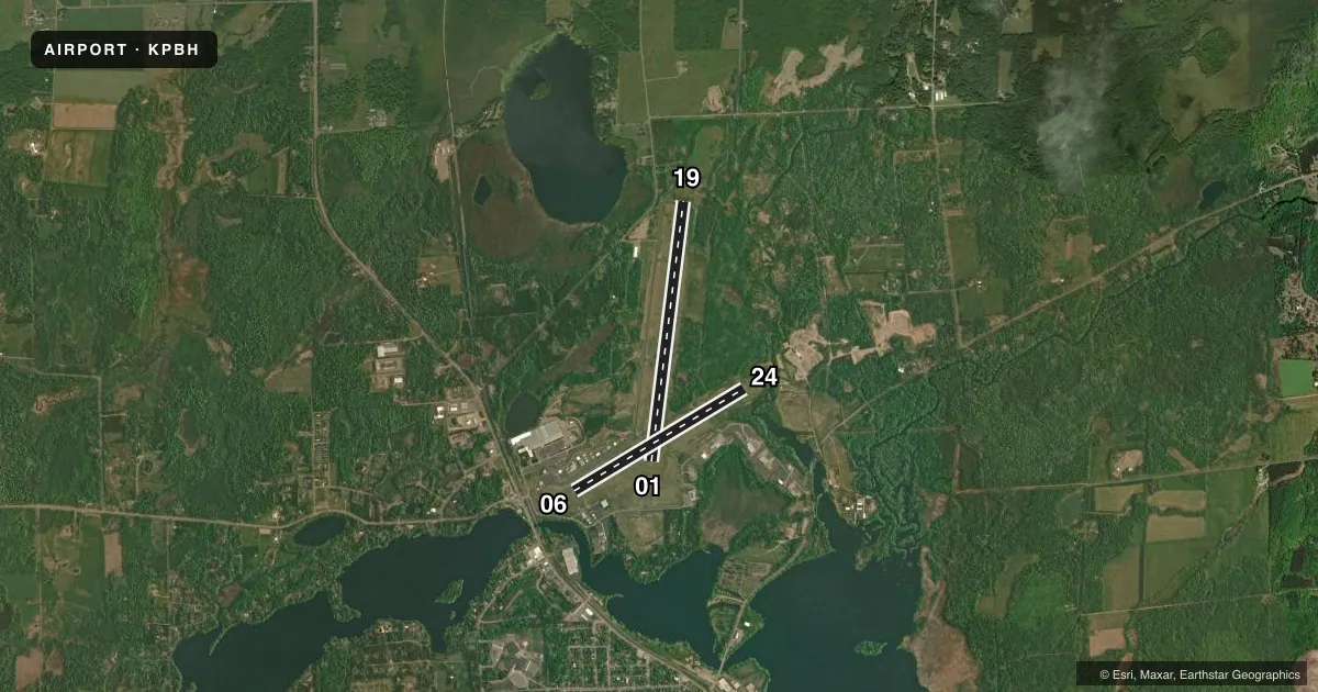
Runways & pattern
Full pagePattern entry · RWY 19
LEFT TRAFFIC| Runway | Heading (°M) | Length | Surface | Traffic |
|---|---|---|---|---|
| 01/19Favored | 7° / 187° | 5,220 ft | ASPH | Standard L |
| 06/24 | 59° / 239° | 3,951 ft | ASPH | Standard L |
Runway end performance
| End | TORA | TODA | ASDA | LDA | VGSI | Approach lights | Obstruction |
|---|---|---|---|---|---|---|---|
| 01 | — | — | — | — | PAPI 2-box left(3°) | — | 58', trees, 1850' from thr, 300' R of cntrln, slope 28 |
| 19 | — | — | — | — | PAPI 2-box left(3°) | — | — |
| 06 | — | — | — | — | VASI 2-box left(4°) | — | — |
| 24 | — | — | — | — | VASI 2-box left(3°) | — | 110', trees, 2070' from thr, 35' R of cntrln, slope 17 |
Declared distances in feet. TORA = takeoff run available, TODA = takeoff distance, ASDA = accelerate-stop, LDA = landing distance.
Airport sketch
Runways drawn to scale from FAA survey coordinates, rendered over satellite imagery. Not for navigation.
Approaches & charts
Services on the field
Fuel grades, oxygen, maintenance, ramp storage and lighting — as declared to the FAA by the airport operator.
Fuel & services
- Fuel
- 100LLA+UL91
- Oxygen (bottled)
- Not available
- Oxygen (bulk)
- Not available
- Airframe repair
- Major
- Power plant repair
- Not available
- Other services
- INSTR
Ramp & ground
- Transient storage
- Tie-down
- Landing fee
- No fee published
- Customs
- Not available
- Lighting schedule
- SEE RMK
- Beacon schedule
- SS-SR
- Beacon
- White / Green (civil land)(WG)
- Wind indicator
- Lighted
- Segmented circle
- Yes
Fuel & FBOs
Cheapest 100LL and Jet A on the field and nearby. Always confirm with the FBO before taxi.
Airport notes
Surface conditions, obstructions, local procedures, lighting outages and other notes published with each FAA cycle.
General notes
- BIRDS ON & INVOF ARPT.
- FOR CD IF UNA TO CTC ON FSS FREQ, CTC MINNEAPOLIS ARTCC AT 651-463-5588.
Lighting notes
- MIRL RWY 01/19 PRESET TO LOW SS-SR; TO INCR INTST & ACTVT REIL RWY 01, 19 & 24; PAPI RWY 01 & 19; VASI RWY 06 & 24; MIRL RWY 06/24 - CTAF.
Fuel notes
- 100LLFUEL AVBL 24 HRS WITH CREDIT CARD.
VFR map & nearby airports
VFR sectional. Tap any ICAO chip to open that airport.
Key facts · KPBH
Answer card- ICAO
- KPBH
- Name
- PRICE COUNTY
- Location
- PHILLIPS, WISCONSIN
- Elevation
- 1,497.1 ft MSL
- Traffic pattern altitude
- 2,497.1 ft MSL (1,000 AGL)
- Control tower
- Non-towered (use CTAF)
- Total runways
- 2
- Longest runway
- 01/19 · 5,220 ft
- Published ILS approaches
- 0
- Published frequencies
- 2
- Magnetic variation
- 0°
- Current flight rules
- VFR
- Current wind
- 180° at 5 kt
- Favored runway now
- RWY 19
Price County Airport sits in Phillips, Wisconsin. Field elevation is 1,497.1 ft MSL. It has two asphalt runways. The longest is runway 01/19 at 5,220 ft. There is no control tower. CTAF and UNICOM are both 122.8.
No ILS approaches are published here. Pattern altitude is not published, so use the standard 1,000 ft AGL for light piston traffic unless the current Chart Supplement says otherwise. The on-field FBO is Price County Airport. It carries 100LL, Jet A and mogas. Fuel is available 24 hours with credit card.
Runway lighting is worth a quick check before night work. Runway 01/19 lights are preset low from sunset to sunrise. Use the CTAF to raise intensity and activate the runway end identifier lights. That also brings up the PAPI for 01 and 19. It brings up the VASI for 06 and 24. Birds are reported on and near the airport, so keep a sharp scan on departure and arrival. With no tower and no published ILS, plan ahead for your approach. This matters especially in marginal weather or at night.