METAR & TAF D25
Current METAR
Observed 17:15Z
KD25 271715Z AUTO 00000KT 10SM BKN027 BKN033 25/21 A2970 RMK AO2 LTG DSNT SE T02450205
- Wind
- 000° @ 0 kt
- Visibility
- 10 SM
- Temp / Dew
- 25°C / 21°C
- Altimeter
- 29.70 inHg
- Clouds
- BKN
- Density alt
- 3,470 ft
- Ceiling
- 2,700 ft AGL
- Rules
- MVFR
Airport info & contacts
Manager on record, flight service, ARTCC, attendance schedule and pattern altitude — published by the FAA and refreshed every 28 days.
Location
- From city
- 1 NM S
- VFR sectional
- GREEN BAY
- ARTCC
- ZMP · MINNEAPOLIS
- NOTAM facility
- GRB (NOTAM-D)
Airport manager
- Name
- JOHN HANSON
- Phone
- 715-904-0502
- Address
- P.O. BOX 267, MANITOWISH WATERS WI 54545
Flight service · Hours
- FSS GRB
- GREEN BAY1-800-WX-BRIEF
- Attendance
- Unattended
Frequencies
Tap any row to copy the frequency to your clipboard.
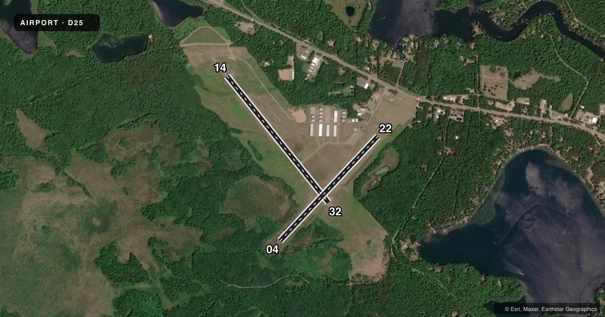
Runways & pattern
Full pagePattern entry · RWY 14
LEFT TRAFFIC| Runway | Heading (°M) | Length | Surface | Traffic |
|---|---|---|---|---|
| 14/32 | 140° / 320° | 3,498 ft | ASPH | Standard L |
| 04/22 | 42° / 222° | 3,094 ft | TURF | Standard L |
Runway end performance
| End | TORA | TODA | ASDA | LDA | VGSI | Approach lights | Obstruction |
|---|---|---|---|---|---|---|---|
| 14 | — | — | — | — | PAPI 2-box left(3.5°) | — | — |
| 32 | — | — | — | — | PAPI 2-box left(3.5°) | — | 70', trees, 1575' from thr, 50' R of cntrln, slope 19 |
| 04 | — | — | — | — | — | — | 45', trees, 450' from thr, 80' R of cntrln, slope 10 |
| 22 | — | — | — | — | — | — | 85', trees, 1120' from thr, 200' R of cntrln, slope 13 |
Declared distances in feet. TORA = takeoff run available, TODA = takeoff distance, ASDA = accelerate-stop, LDA = landing distance.
Airport sketch
Runways drawn to scale from FAA survey coordinates, rendered over satellite imagery. Not for navigation.
Approaches & charts
Services on the field
Fuel grades, oxygen, maintenance, ramp storage and lighting — as declared to the FAA by the airport operator.
Fuel & services
- Fuel
- 100LL
- Airframe repair
- Not available
- Power plant repair
- Not available
Ramp & ground
- Transient storage
- Tie-down
- Landing fee
- No fee published
- Customs
- Not available
- Lighting schedule
- SEE RMK
- Beacon schedule
- SS-SR
- Beacon
- White / Green (civil land)(WG)
- Wind indicator
- Lighted
- Segmented circle
- Yes
Fuel & FBOs
Cheapest 100LL and Jet A on the field and nearby. Always confirm with the FBO before taxi.
Airport notes
Surface conditions, obstructions, local procedures, lighting outages and other notes published with each FAA cycle.
General notes
- 122 FT AGL/1737 FT MSL TWR APRXLY 1000 FT E OF ARPT.
- DEER & COYOTES ON & INVOF ARPT.
- BIRDS AND MIGRATORY WATERFOWL ON & INVOF ARPT.
- FOR CD CTC MINNEAPOLIS ARTCC AT 651-463-5588.
Lighting notes
- MIRL RWY 14/32 PRESET TO LOW SS-SR; TO INCR INTST & ACTVT REIL RWY 14 & 32; PAPI RWY 14 & 32; MIRL RWY 14/32 - CTAF.
Fuel notes
- 100LL24 HR SELF SVC FUEL AVBL WITH CREDIT CARD.
Runway surface & condition
- 04/22CLSD IN WINTER.
Approach & departure obstructions
- 04MKD WITH YELLOW CONES.
- 22MKD WITH YELLOW CONES.
VFR map & nearby airports
VFR sectional. Tap any ICAO chip to open that airport.
Key facts · D25
Answer card- ICAO
- D25
- Name
- MANITOWISH WATERS
- Location
- MANITOWISH WATERS, WISCONSIN
- Elevation
- 1,610.3 ft MSL
- Traffic pattern altitude
- 2,610.3 ft MSL (1,000 AGL)
- Control tower
- Non-towered (use CTAF)
- Total runways
- 2
- Longest runway
- 14/32 · 3,498 ft
- Published ILS approaches
- 0
- Published frequencies
- 2
- Magnetic variation
- 1°
- Current flight rules
- MVFR
- Current wind
- 000° at 0 kt
- Favored runway now
- –
Manitowish Waters Airport (D25) sits in Manitowish Waters, Wisconsin. Field elevation is 1,610.3 ft MSL. The airport has two runways. The longest is runway 14/32 at 3,498 ft. Runway 04/22 is 3,094 ft turf. There is no control tower. The published traffic pattern altitude is not listed. Use the standard 1,000 ft AGL pattern for light piston aircraft unless the current Chart Supplement says otherwise.
No ILS approaches are published here. For IFR planning, check the current Chart Supplement and your approach setup before you go. The on-field FBO is Manitowish Waters Airport. It carries 100LL. Twenty-four hour self-serve 100LL is available with credit card. The published remarks also note birds, migratory waterfowl, deer and coyotes in the area. That matters on departure and in the pattern. Runway 04/22 is closed in winter. Runway 22 and runway 04 are marked with yellow cones. Runway 14/32 has medium intensity lights preset low from sunset to sunrise. CTAF use increases the lights and activates the runway end identifier lights on 14 and 32.
This is a non-towered field with a high field elevation. Expect density altitude to matter in warm weather. Clearance delivery is handled through Minneapolis ARTCC when needed. Check the current Chart Supplement before flight for any changes to lighting, seasonal runway status, or other local procedures.