METAR & TAF KHYR
Current METAR
Observed 04:53Z
KHYR 270453Z AUTO 00000KT 10SM CLR 23/22 A2980 RMK AO2 SLP085 T02280222
- Wind
- 000° @ 0 kt
- Visibility
- 10 SM
- Temp / Dew
- 23°C / 22°C
- Altimeter
- 29.80 inHg
- Clouds
- CLR
- Density alt
- 2,617 ft
- Ceiling
- Unlimited
- Rules
- VFR
Airport info & contacts
Manager on record, flight service, ARTCC, attendance schedule and pattern altitude — published by the FAA and refreshed every 28 days.
Location
- From city
- 2 NM NE
- VFR sectional
- GREEN BAY
- ARTCC
- ZMP · MINNEAPOLIS
- NOTAM facility
- HYR (NOTAM-D)
Airport manager
- Name
- DEREK LESLIE
- Phone
- 715-634-4624
- Address
- 10930 N ARPT RD, HAYWARD WI 54843
Flight service · Hours
- FSS GRB
- GREEN BAY1-800-WX-BRIEF
- Attendance
- MAY-OCT · 0800-1800
- NOV - APR · 0800 -1700
Frequencies
Tap any row to copy the frequency to your clipboard.
Runways & pattern
Full pagePattern entry · RWY 03
LEFT TRAFFIC| Runway | Heading (°M) | Length | Surface | Traffic |
|---|---|---|---|---|
| 03/21 | 25° / 205° | 5,003 ft | ASPH | Standard L |
| 16/34 | 163° / 343° | 1,088 ft | TURF | Standard L |
Runway end performance
| End | TORA | TODA | ASDA | LDA | VGSI | Approach lights | Obstruction |
|---|---|---|---|---|---|---|---|
| 03 | — | — | — | — | PAPI 4-box left(3°) | — | 7', fence, 260' from thr, 500' R of cntrln, slope 8 |
| 21 | — | — | — | — | PAPI 4-box right(3°) | MALSR | 88', trees, 3200' from thr, 330' R of cntrln, slope 34 |
| 16 | — | — | — | — | — | — | 60', trees, 1030' from thr, 200' R of cntrln, slope 17 |
| 34 | — | — | — | — | — | — | 53', trees, 700' from thr, 175' R of cntrln, slope 13 |
Declared distances in feet. TORA = takeoff run available, TODA = takeoff distance, ASDA = accelerate-stop, LDA = landing distance.
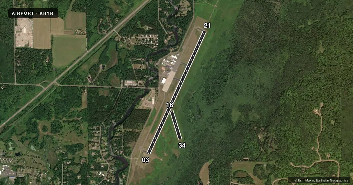
Airport sketch
Runways drawn to scale from FAA survey coordinates, rendered over satellite imagery. Not for navigation.
Approaches & charts
ILS · 1
Services on the field
Fuel grades, oxygen, maintenance, ramp storage and lighting — as declared to the FAA by the airport operator.
Fuel & services
- Fuel
- 100LLA+
- Oxygen (bottled)
- Not available
- Oxygen (bulk)
- Not available
- Airframe repair
- Not available
- Power plant repair
- Not available
- Other services
- INSTR,RNTL
Ramp & ground
- Transient storage
- Tie-down
- Hangar
- Landing fee
- No fee published
- Customs
- Not available
- Lighting schedule
- SEE RMK
- Beacon schedule
- SS-SR
- Beacon
- White / Green (civil land)(WG)
- Wind indicator
- Lighted
- Segmented circle
- No
Fuel & FBOs
Cheapest 100LL and Jet A on the field and nearby. Always confirm with the FBO before taxi.
Airport notes
Surface conditions, obstructions, local procedures, lighting outages and other notes published with each FAA cycle.
General notes
- BIRDS ON & INVOF ARPT.
- ARPT COND UNMON 1700-0800.
- FOR CD IF UNA VIA FREQ CTC MINNEAPOLIS ARTCC AT 651-463-5588.
Lighting notes
- ACTVT MALSR RWY 21; REIL RWY 03; PAPI RWY 03 & 21; HIRL RWY 03/21 - CTAF. SS-SR HIRL RWY 03/21 PRESET TO LOW; TO INCR INTST - CTAF.
Runway surface & condition
- 03/21PCR VALUE: 290/F/C/X/T
- 16/34CLSD DEC 1 - APR 15.
Approach & departure obstructions
- 16YELLOW CONES.
- 34YELLOW CONES.
VFR map & nearby airports
VFR sectional. Tap any ICAO chip to open that airport.
Key facts · KHYR
Answer card- ICAO
- KHYR
- Name
- SAWYER COUNTY
- Location
- HAYWARD, WISCONSIN
- Elevation
- 1,215.9 ft MSL
- Traffic pattern altitude
- 2,215.9 ft MSL (1,000 AGL)
- Control tower
- Non-towered (use CTAF)
- Total runways
- 2
- Longest runway
- 03/21 · 5,003 ft
- Published ILS approaches
- 1
- Published frequencies
- 2
- Magnetic variation
- 0°
- Current flight rules
- VFR
- Current wind
- 000° at 0 kt
- Favored runway now
- –
Sawyer County Airport sits in Hayward, Wisconsin. Field elevation is 1,215.9 ft MSL. The airport has two runways. The longest is runway 03/21 at 5,003 ft. Runway 16/34 is turf and measures 1,088 ft. There is no control tower. CTAF and UNICOM are both 122.8.
Runway 21 has the ILS approach. Runway 03/21 also has MALSR lighting. Runway 03 has REIL. PAPI is available on runways 03 and 21. The high intensity runway lights on 03 and 21 are controlled by CTAF. From sunset to sunrise, they come up at low intensity first. You can ask for more intensity on frequency. Pattern altitude is not published. Use 1,000 ft AGL for light piston traffic unless the current Chart Supplement says otherwise.
Hayward Aviation is on the field. It carries AVGAS 100LL and Jet A. Runway 16 and runway 34 are closed from December 1 to April 15. Yellow cones mark the ends of those turf runways. Airport condition is unmonitored from 1700 to 0800. Birds are present on and near the airport. If you need clearance delivery when frequency contact is not available, call Minneapolis ARTCC. For a first-time arrival, expect a non-towered field with night lighting control on CTAF and check the current Chart Supplement for any changes before you go.