METAR & TAF 13Y
13Y does not publish a METAR.
Showing the nearest reporting station: KINL (FALLS INTL/EINARSON FLD) · 11.8 NM away. Conditions at 13Y may differ.
METAR · KINL
Observed 18:54Z
KINL 271854Z AUTO 03006KT 10SM OVC011 22/19 A2982 RMK AO2 SLP096 T02170194 $
- Wind
- 030° @ 6 kt
- Visibility
- 10 SM
- Temp / Dew
- 22°C / 19°C
- Altimeter
- 29.82 inHg
- Clouds
- OVC
- Density alt
- 2,384 ft
- Ceiling
- 1,100 ft AGL
- Rules
- MVFR
Airport info & contacts
Manager on record, flight service, ARTCC, attendance schedule and pattern altitude — published by the FAA and refreshed every 28 days.
Location
- From city
- 2 NM NW
- VFR sectional
- TWIN CITIES
- ARTCC
- ZMP · MINNEAPOLIS
- NOTAM facility
- PNM (NOTAM-D)
Airport manager
- Name
- MIKE FORT
- Phone
- 218-278-6710
- Address
- 901 MAIN ST., BOX 135, LITTLEFORK MN 56653
Flight service · Hours
- FSS PNM
- PRINCETON1-800-WX-BRIEF
- Attendance
- Unattended
Frequencies
Tap any row to copy the frequency to your clipboard.
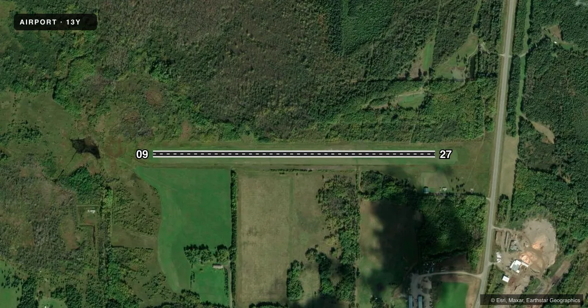
Runways & pattern
Full pagePattern entry · RWY 09
LEFT TRAFFICAirport sketch
Runways drawn to scale from FAA survey coordinates, rendered over satellite imagery. Not for navigation.
Approaches & charts
Services on the field
Fuel grades, oxygen, maintenance, ramp storage and lighting — as declared to the FAA by the airport operator.
Fuel & services
- Fuel
- Not available
- Oxygen (bottled)
- Not available
- Oxygen (bulk)
- Not available
- Airframe repair
- Not available
- Power plant repair
- Not available
Ramp & ground
- Transient storage
- Tie-down
- Landing fee
- No fee published
- Customs
- Not available
- Wind indicator
- Yes
- Segmented circle
- No
Fuel & FBOs
Cheapest 100LL and Jet A on the field and nearby. Always confirm with the FBO before taxi.
Airport notes
Surface conditions, obstructions, local procedures, lighting outages and other notes published with each FAA cycle.
General notes
- ARPT NOT PLOWED WINTER MONTHS.
- ULTRALIGHT TRAFFIC ON & INVOF ARPT.
- ANTENNA 25 FT, 500 FT 'SE' OF RY, MARKED AND LIGHTED.
- FOR CD CTC MINNEAPOLIS ARTCC AT 651-463-5588.
Approach & departure obstructions
- 09RY 09/27 MKD WITH YELLOW CONES.
Other notes
- PRVDD OBSTNS IN RWY APCH SLOPE SFCS ARE RMVD/LWRD OR RWY THR DSPLCD & MKD SO AS TO PRVD A MIN 20:1 APP CLRNC OVR THE OBSTNS.
VFR map & nearby airports
VFR sectional. Tap any ICAO chip to open that airport.
Key facts · 13Y
Answer card- ICAO
- 13Y
- Name
- LITTLEFORK MUNI/HANOVER
- Location
- LITTLEFORK, MINNESOTA
- Elevation
- 1,145 ft MSL
- Traffic pattern altitude
- 2,145 ft MSL (1,000 AGL)
- Control tower
- Non-towered (use CTAF)
- Total runways
- 1
- Longest runway
- 09/27 · 3,000 ft
- Published ILS approaches
- 0
- Published frequencies
- 1
- Magnetic variation
- 3°
- Current flight rules
- MVFR
- Current wind
- 030° at 6 kt
- Favored runway now
- RWY 09
Littlefork Muni/Hanover is in Littlefork, Minnesota. The field elevation is 1,145 ft MSL. It has one runway. Runway 09/27 is 3,000 ft of turf, so plan for grass performance and seasonal surface changes. The airport is non-towered. CTAF is 122.9.
No ILS approaches are published here. Pattern altitude is not published, so use 1,000 ft AGL for light piston operations unless the current Chart Supplement says otherwise. That puts the standard pattern near 2,145 ft MSL based on the field elevation. The airport remarks also note ultralight traffic in and around the field. Expect to keep a sharp lookout in the pattern.
Published remarks say the runway has yellow cone marking on 09/27. They also note a 25 ft antenna about 500 ft southeast of the runway. It is marked and lighted. The airport is not plowed in winter months. That matters here. Check surface condition before you go, especially after snow or freeze-thaw cycles. For IFR clearance delivery, contact Minneapolis ARTCC at 651-463-5588. There are no on-field FBOs listed, so verify fuel and service options with the airport operator or by calling the field directly before arrival.