METAR & TAF KVWU
Current METAR
Observed 02:55Z
KVWU 280255Z AUTO 00000KT 10SM SCT060 23/23 A2986 RMK AO2
- Wind
- 000° @ 0 kt
- Visibility
- 10 SM
- Temp / Dew
- 23°C / 23°C
- Altimeter
- 29.86 inHg
- Clouds
- SCT
- Density alt
- 2,503 ft
- Ceiling
- Unlimited
- Rules
- VFR
Airport info & contacts
Manager on record, flight service, ARTCC, attendance schedule and pattern altitude — published by the FAA and refreshed every 28 days.
Location
- From city
- 1 NM S
- VFR sectional
- TWIN CITIES
- ARTCC
- ZMP · MINNEAPOLIS
- NOTAM facility
- VWU (NOTAM-D)
Airport manager
- Name
- RAY BERGER
- Phone
- 218-766-1523
- Address
- 54450 FRANKIE LN NE, WASKISH MN 56685-4015
Flight service · Hours
- FSS PNM
- PRINCETON1-800-WX-BRIEF
- Attendance
- Unattended
Frequencies
Tap any row to copy the frequency to your clipboard.
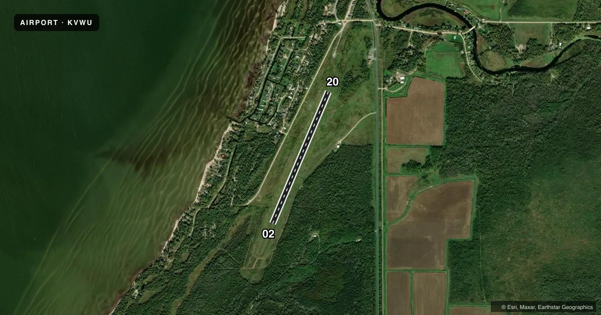
Runways & pattern
Full pagePattern entry · RWY 02
LEFT TRAFFICAirport sketch
Runways drawn to scale from FAA survey coordinates, rendered over satellite imagery. Not for navigation.
Approaches & charts
Services on the field
Fuel grades, oxygen, maintenance, ramp storage and lighting — as declared to the FAA by the airport operator.
Fuel & services
- Fuel
- Not available
- Oxygen (bottled)
- Not available
- Oxygen (bulk)
- Not available
- Airframe repair
- Not available
- Power plant repair
- Not available
Ramp & ground
- Transient storage
- Tie-down
- Landing fee
- No fee published
- Customs
- Not available
- Wind indicator
- Yes
- Segmented circle
- No
Fuel & FBOs
Cheapest 100LL and Jet A on the field and nearby. Always confirm with the FBO before taxi.
Airport notes
Surface conditions, obstructions, local procedures, lighting outages and other notes published with each FAA cycle.
General notes
- FOR CD CTC MINNEAPOLIS ARTCC AT 651-463-5588.
Approach & departure obstructions
- 02YELLOW CONES.
- 20YELLOW CONES.
Other notes
- ESTABD BFR 1959.
- ELEC OUTLETS AVBL NEAR TIEDOWNS.
- 02/20TURF HAD SVRL BARE SPOTS WITH SAND SHOWING THRU.
VFR map & nearby airports
VFR sectional. Tap any ICAO chip to open that airport.
Key facts · KVWU
Answer card- ICAO
- KVWU
- Name
- WASKISH MUNI
- Location
- WASKISH, MINNESOTA
- Elevation
- 1,184.6 ft MSL
- Traffic pattern altitude
- 2,184.6 ft MSL (1,000 AGL)
- Control tower
- Non-towered (use CTAF)
- Total runways
- 1
- Longest runway
- 02/20 · 2,992 ft
- Published ILS approaches
- 0
- Published frequencies
- 1
- Magnetic variation
- 4°
- Current flight rules
- VFR
- Current wind
- 000° at 0 kt
- Favored runway now
- –
Waskish Muni is in Waskish, Minnesota. The field elevation is 1,184.6 ft MSL. It has one runway. Runway 02/20 is 2,992 ft of turf, so plan for soft-field technique and check the surface before you go. The airport is non-towered. CTAF is 122.9.
No ILS approaches are published here. Pattern altitude is not published, so use the standard 1,000 ft AGL pattern unless the current FAA Chart Supplement says otherwise. The runway headings are magnetic. Runway 02 is marked with yellow cones at the end. Runway 20 is marked the same way. The turf has several bare spots with sand showing through, which matters if the field has been wet or if you are planning a heavier load.
There are no on-field FBOs listed. Contact the airport operator directly or call the field on CTAF for current service options before arrival. Electric outlets are available near the tiedowns. For clearance delivery, Minneapolis ARTCC can be reached at 651-463-5588. This is a small, rural strip with a single turf runway, so a careful surface check and a conservative performance plan make sense before you launch or land.