METAR & TAF KBDE
Current METAR
Observed 03:53Z
KBDE 280353Z AUTO 07003KT 10SM CLR 19/18 A2987 RMK AO2 SLP114 T01890183
- Wind
- 070° @ 3 kt
- Visibility
- 10 SM
- Temp / Dew
- 19°C / 18°C
- Altimeter
- 29.87 inHg
- Clouds
- CLR
- Density alt
- 1,888 ft
- Ceiling
- Unlimited
- Rules
- VFR
Airport info & contacts
Manager on record, flight service, ARTCC, attendance schedule and pattern altitude — published by the FAA and refreshed every 28 days.
Location
- From city
- 1 NM N
- VFR sectional
- TWIN CITIES
- ARTCC
- ZMP · MINNEAPOLIS
- NOTAM facility
- BDE (NOTAM-D)
Airport manager
- Name
- PETE DUNN
- Phone
- 218-839-6488
- Address
- 1103 AIRPORT ROAD NW, PO BOX 712, BAUDETTE MN 56623-0712
Flight service · Hours
- FSS PNM
- PRINCETON1-800-WX-BRIEF
- Attendance
- APR-OCT · 0800-2000
- NOV-MAR · 0800-1700
Frequencies
Tap any row to copy the frequency to your clipboard.
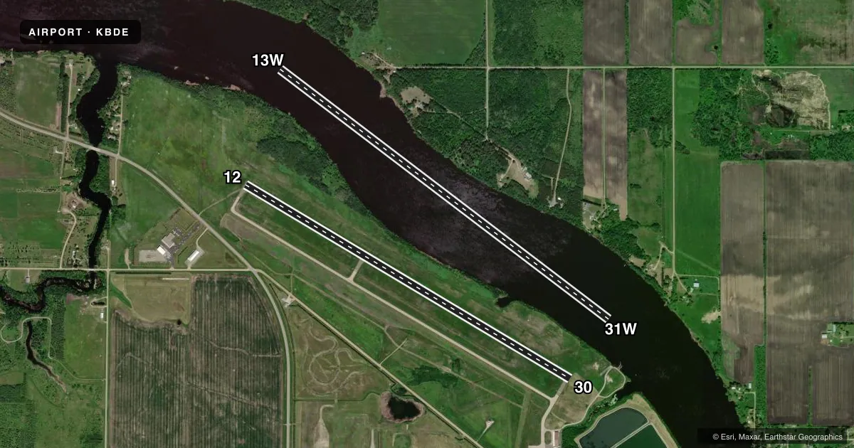
Runways & pattern
Full pagePattern entry · RWY 12
LEFT TRAFFIC| Runway | Heading (°M) | Length | Surface | Traffic |
|---|---|---|---|---|
| 13W/31W | 123° / 303° | 6,000 ft | WATER | Standard L |
| 12/30Favored | 117° / 297° | 5,498 ft | ASPH | Standard L |
Runway end performance
| End | TORA | TODA | ASDA | LDA | VGSI | Approach lights | Obstruction |
|---|---|---|---|---|---|---|---|
| 12 | — | — | — | — | PAPI 4-box left(3°) | — | — |
| 30 | — | — | — | — | PAPI 4-box left(3°) | — | 11', trees, 686' from thr, 0' R of cntrln, slope 44 |
Declared distances in feet. TORA = takeoff run available, TODA = takeoff distance, ASDA = accelerate-stop, LDA = landing distance.
Airport sketch
Runways drawn to scale from FAA survey coordinates, rendered over satellite imagery. Not for navigation.
Approaches & charts
ILS · 1
Services on the field
Fuel grades, oxygen, maintenance, ramp storage and lighting — as declared to the FAA by the airport operator.
Fuel & services
- Fuel
- 100LLA
- Oxygen (bottled)
- Not available
- Oxygen (bulk)
- Not available
- Airframe repair
- Major
- Power plant repair
- Major
- Other services
- AVNCS,BCHGR,SALES
Ramp & ground
- Transient storage
- Tie-down
- Hangar
- Landing fee
- No fee published
- Customs
- Available
- Lighting schedule
- SEE RMK
- Beacon schedule
- SS-SR
- Beacon
- White / Green (civil land)(WG)
- Wind indicator
- Lighted
- Segmented circle
- Yes
Fuel & FBOs
Cheapest 100LL and Jet A on the field and nearby. Always confirm with the FBO before taxi.
Airport notes
Surface conditions, obstructions, local procedures, lighting outages and other notes published with each FAA cycle.
General notes
- SEAPLANE LNDG AREA ADJACENT NORTH OF LAND FACILITY.
- GULLS & OTR BIRDS ON & INVOF ARPT.
- FOR CD IF UNA TO CTC ON FSS FREQ, CTC MINNEAPOLIS ARTCC AT 651-463-5588.
Lighting notes
- ACTVT OR INCR INTST REIL RWY 12 & 30; PAPI RWY 12 & 30; HIRL RWY 12/30 - CTAF. HIRL RWY 12/30 PRESET LOW INTST.
Fuel notes
- 100LLFOR FUEL AFT HRS CALL AMGR.
Other notes
- FLIGHT NOTIFICATION SERVICE (ADCUS) AVBL.
- 1FOR ATTENDANT OTR TIMES CALL AMGR OR 218-839-6488.
- OWNERAND CITY OF BAUDETTE.
VFR map & nearby airports
VFR sectional. Tap any ICAO chip to open that airport.
Key facts · KBDE
Answer card- ICAO
- KBDE
- Name
- BAUDETTE INTL
- Location
- BAUDETTE, MINNESOTA
- Elevation
- 1,085.4 ft MSL
- Traffic pattern altitude
- 2,085.4 ft MSL (1,000 AGL)
- Control tower
- Non-towered (use CTAF)
- Total runways
- 2
- Longest runway
- 13W/31W · 6,000 ft
- Published ILS approaches
- 1
- Published frequencies
- 2
- Magnetic variation
- 4°
- Current flight rules
- VFR
- Current wind
- 070° at 3 kt
- Favored runway now
- RWY 12
Baudette Intl is in Baudette, Minnesota. The field elevation is 1,085.4 ft MSL. It has 2 runways. The longest is 6,000 ft on the water runway 13W/31W. The asphalt runway 12/30 is 5,498 ft. This is an uncontrolled airport with CTAF and UNICOM both on 122.8. The published pattern altitude is not listed, so use the standard 1,000 ft AGL for light piston operations unless the current Chart Supplement says otherwise.
Runway 30 has an ILS approach. That is the only published ILS in the facts here. The runway lighting is pilot-controlled on CTAF. That includes runway end identifier lights, PAPI on 12 and 30 and high intensity runway lights on 12/30. The HIRL is preset to low intensity. The airport is owned by the city of Baudette. There is a seaplane landing area just north of the land facility, so watch for mixed fixed-wing and floatplane traffic in the area.
No on-field FBOs are listed in the facts. For fuel or after-hours help, call the airport manager. Birds are reported on and near the airport, so keep an eye out on approach and departure. If you need clearance delivery and cannot reach Flight Service, contact Minneapolis ARTCC at 651-463-5588.