METAR & TAF KINL
Current METAR
Observed 21:54Z
KINL 272154Z AUTO 02005KT 10SM CLR 26/19 A2982 RMK AO2 SLP092 T02560189 $
- Wind
- 020° @ 5 kt
- Visibility
- 10 SM
- Temp / Dew
- 26°C / 19°C
- Altimeter
- 29.82 inHg
- Clouds
- CLR
- Density alt
- 2,913 ft
- Ceiling
- Unlimited
- Rules
- VFR
Airport info & contacts
Manager on record, flight service, ARTCC, attendance schedule and pattern altitude — published by the FAA and refreshed every 28 days.
Location
- From city
- 0 NM S
- VFR sectional
- TWIN CITIES
- ARTCC
- ZMP · MINNEAPOLIS
- NOTAM facility
- INL (NOTAM-D)
Airport manager
- Name
- THOR EINARSON
- Phone
- 218-283-4461
- Address
- 3214 2ND AVE E, INTERNATIONAL FALLS MN 56649-8955
Flight service · Hours
- FSS PNM
- PRINCETON1-800-WX-BRIEF
- Attendance
- DALGT
Frequencies
Tap any row to copy the frequency to your clipboard.
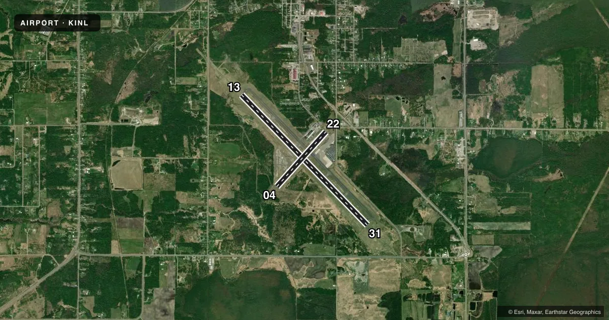
Runways & pattern
Full pagePattern entry · RWY 04
LEFT TRAFFIC| Runway | Heading (°M) | Length | Surface | Traffic |
|---|---|---|---|---|
| 13/31 | 133° / 313° | 7,400 ft | ASPH | Standard L |
| 04/22Favored | 39° / 219° | 2,999 ft | ASPH | Standard L |
Runway end performance
| End | TORA | TODA | ASDA | LDA | VGSI | Approach lights | Obstruction |
|---|---|---|---|---|---|---|---|
| 13 | 7,400' | 7,400' | 7,400' | 7,400' | PAPI 4-box left(3°) | MALSR | — |
| 31 | 7,400' | 7,400' | 7,400' | 7,400' | PAPI 4-box left(3°) | MALSR | — |
| 04 | 2,999' | 2,999' | 2,999' | 2,999' | — | — | — |
| 22 | 2,999' | 2,999' | 2,999' | 2,999' | — | — | — |
Declared distances in feet. TORA = takeoff run available, TODA = takeoff distance, ASDA = accelerate-stop, LDA = landing distance.
Airport sketch
Runways drawn to scale from FAA survey coordinates, rendered over satellite imagery. Not for navigation.
Approaches & charts
ILS · 2
Services on the field
Fuel grades, oxygen, maintenance, ramp storage and lighting — as declared to the FAA by the airport operator.
Fuel & services
- Fuel
- 100LLA
- Oxygen (bottled)
- Not available
- Oxygen (bulk)
- Not available
- Other services
- AMB,CHTR,INSTR,RNTL
Ramp & ground
- Transient storage
- Tie-down
- Hangar
- Landing fee
- No fee published
- Customs
- Available
- Lighting schedule
- SEE RMK
- Beacon schedule
- SS-SR
- Beacon
- White / Green (civil land)(WG)
- Wind indicator
- Lighted
- Segmented circle
- Yes
Fuel & FBOs
Cheapest 100LL and Jet A on the field and nearby. Always confirm with the FBO before taxi.
Airport notes
Surface conditions, obstructions, local procedures, lighting outages and other notes published with each FAA cycle.
General notes
- GULLS & DEER ON & INVOF ARPT.
- FOR CD IF UNA TO CTC ON FSS FREQ, CTC MINNEAPOLIS ARTCC AT 651-463-5588.
- FLD CONDS UNMON 0000-0500, CALL 218-283-2712.
Lighting notes
- ACTVT MALSR RWY 13 & 31; HIRL RWY 13/31 - CTAF. PAPI RWY 13 & 31 OPR CONSLY.
Runway surface & condition
- 04/22PCR VALUE: 100/F/D/X/T
- 13/31PCR VALUE: 670/F/D/X/T
- 04/22RWY 04/22 NOT AVBL FOR PART 121/PART 380 OPS WITH SKED PAX CARRYING OPS MORE THAN 9 PAX SEATS AND NON-SKED PAX CARRYING OPS MORE THAN 30 PAX SEATS. CLSD AT NGT. CLSD DRG WINTER MONTHS.
Other notes
- ACR OPS NA IN EXCESS OF 15 MINS BFR OR AFT SKEDD ARR/DEP TIMES WO PRIOR CDN WITH AMGR. 24 HR PPR FOR UNSKED ACR OPS GTR THAN 30 PAX SEATS - CALL AMGR.
- 1FOR ATTENDANT 0000-0500 CALL 218-283-2712.
- MANAGERTHOR@EINARSONFLYING.COM.
- 13/316500 FT OF RWY 13/31 IS GROOVED. SOUTHERN 900 FT OF RWY 13/31 (APCH END RWY 31) IS NOT GROOVED.
VFR map & nearby airports
VFR sectional. Tap any ICAO chip to open that airport.
Key facts · KINL
Answer card- ICAO
- KINL
- Name
- FALLS INTL/EINARSON FLD
- Location
- INTERNATIONAL FALLS, MINNESOTA
- Elevation
- 1,184.4 ft MSL
- Traffic pattern altitude
- 2,184.4 ft MSL (1,000 AGL)
- Control tower
- Non-towered (use CTAF)
- Total runways
- 2
- Longest runway
- 13/31 · 7,400 ft
- Published ILS approaches
- 2
- Published frequencies
- 2
- Magnetic variation
- 3°
- Current flight rules
- VFR
- Current wind
- 020° at 5 kt
- Favored runway now
- RWY 04
Falls Intl/Einarson Fld sits in International Falls, Minnesota, near the Canadian border. The field elevation is 1,184.4 ft MSL. It has two asphalt runways. The longest is 13/31 at 7,400 ft. Runway 04/22 is 2,999 ft.
There is no control tower. CTAF and UNICOM are both 122.8. The published pattern altitude is not listed, so use the standard 1,000 ft AGL for light piston ops unless ATC or the current Chart Supplement says otherwise. The field has 2 ILS approaches. Both are on runway ends 13 and 31. MALSR is active on 13 and 31. High intensity runway lights on 13/31 are controlled by CTAF. PAPI on 13 and 31 operates continuously.
Einarson Flying Service is on the field. It carries 100LL and Jet A with Prist. If you need an attendant between 0000 and 0500, call ahead. Field conditions are unmonitored from 0000 to 0500. Runway 04/22 is closed at night and during winter months. It is also not available for certain large scheduled passenger operations. Gulls and deer are reported on and near the airport. Plan for that on taxi, takeoff and landing.