METAR & TAF KRRT
Current METAR
Observed 09:55Z
KRRT 260955Z AUTO 20003KT 10SM CLR 19/18 A2978 RMK AO2
- Wind
- 200° @ 3 kt
- Visibility
- 10 SM
- Temp / Dew
- 19°C / 18°C
- Altimeter
- 29.78 inHg
- Clouds
- CLR
- Density alt
- 1,987 ft
- Ceiling
- Unlimited
- Rules
- VFR
Airport info & contacts
Manager on record, flight service, ARTCC, attendance schedule and pattern altitude — published by the FAA and refreshed every 28 days.
Location
- From city
- 2 NM NW
- VFR sectional
- TWIN CITIES
- ARTCC
- ZMP · MINNEAPOLIS
- NOTAM facility
- RRT (NOTAM-D)
Airport manager
- Name
- MATT RACHUY
- Phone
- 218-386-1691
- Address
- PO BOX 50, 36955 COUNTY ROAD 13, WARROAD MN 56763-0050
Flight service · Hours
- FSS PNM
- PRINCETON1-800-WX-BRIEF
- Attendance
- MON-FRI · 0700-1700
Frequencies
Tap any row to copy the frequency to your clipboard.
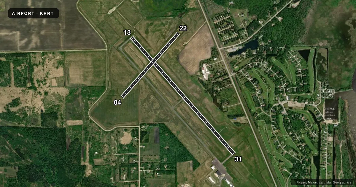
Runways & pattern
Full pagePattern entry · RWY 22
LEFT TRAFFIC| Runway | Heading (°M) | Length | Surface | Traffic |
|---|---|---|---|---|
| 13/31 | 135° / 315° | 5,400 ft | ASPH | Standard L |
| 04/22Favored | 38° / 218° | 2,987 ft | TURF | Standard L |
Runway end performance
| End | TORA | TODA | ASDA | LDA | VGSI | Approach lights | Obstruction |
|---|---|---|---|---|---|---|---|
| 13 | — | — | — | — | PAPI 4-box left(3°) | MALSR | — |
| 31 | — | — | — | — | PAPI 4-box left(3°) | MALSR | — |
Declared distances in feet. TORA = takeoff run available, TODA = takeoff distance, ASDA = accelerate-stop, LDA = landing distance.
Airport sketch
Runways drawn to scale from FAA survey coordinates, rendered over satellite imagery. Not for navigation.
Approaches & charts
ILS · 1
Services on the field
Fuel grades, oxygen, maintenance, ramp storage and lighting — as declared to the FAA by the airport operator.
Fuel & services
- Fuel
- 100LLA
- Oxygen (bottled)
- Not available
- Oxygen (bulk)
- Not available
- Airframe repair
- Not available
- Power plant repair
- Not available
Ramp & ground
- Transient storage
- Tie-down
- Hangar
- Landing fee
- No fee published
- Customs
- Not available
- Lighting schedule
- SEE RMK
- Beacon schedule
- SS-SR
- Beacon
- White / Green (civil land)(WG)
- Wind indicator
- Lighted
- Segmented circle
- No
Fuel & FBOs
Cheapest 100LL and Jet A on the field and nearby. Always confirm with the FBO before taxi.
Airport notes
Surface conditions, obstructions, local procedures, lighting outages and other notes published with each FAA cycle.
General notes
- DEER & BIRDS ON & INVOF ARPT.
- CUST AVBL 1 HR PPR CALL 218-386-1676, CELL 218-689-3880, OTR 218-386-2796.
- GCO AVBL ON FREQ 121.725 (MINNEAPOLIS CENTER AND FLIGHT SERVICES).
- FOR CD IF UNA TO CTC ON FSS FREQ, CTC MINNEAPOLIS ARTCC AT 651-463-5588.
Lighting notes
- ACTVT OR INCR INTST MALSR RWY 13 & 31; HIRL RWY 13/31 - CTAF. PAPI RWY 13 & 31 OPR CONSLY; HIRL RWY 13/31 PRESET LOW INTST. PCL UNAVBL DURG DALGT HRS.
Fuel notes
- 100LLFUEL AVBL H24 SELF SVC VIA CREDIT CARD.
Runway surface & condition
- 04/22CLSD WINTER MONTHS.
Approach & departure obstructions
- 31CALM WIND RWY.
- 04MKD WITH YELLOW CONES.
- 22MKD WITH YELLOW CONES.
Other notes
- FOR HNGR CALL AMGR.
- 1FOR SVC NGTS & WKENDS CALL AMGR.
VFR map & nearby airports
VFR sectional. Tap any ICAO chip to open that airport.
Key facts · KRRT
Answer card- ICAO
- KRRT
- Name
- WARROAD INTL MEML
- Location
- WARROAD, MINNESOTA
- Elevation
- 1,075.5 ft MSL
- Traffic pattern altitude
- 2,075.5 ft MSL (1,000 AGL)
- Control tower
- Non-towered (use CTAF)
- Total runways
- 2
- Longest runway
- 13/31 · 5,400 ft
- Published ILS approaches
- 1
- Published frequencies
- 2
- Magnetic variation
- 4°
- Current flight rules
- VFR
- Current wind
- 200° at 3 kt
- Favored runway now
- RWY 22
Warroad Intl Meml sits in Warroad, Minnesota near the Canadian border. Field elevation is 1,075.5 ft MSL. The airport has two runways. The longest is 13/31 at 5,400 ft asphalt. Runway 04/22 is 2,987 ft turf. There is no control tower. CTAF and UNICOM are both 123.05.
Pattern altitude is not published. Use 1,000 ft AGL for light piston traffic unless the current Chart Supplement or local guidance says otherwise. The field has one ILS approach for runway 31. That matters here because runway 31 is also listed as the calm wind runway. Runway 13/31 lighting is pilot controlled through CTAF. PAPI on 13 and 31 operates continuously. Pilot controlled lighting is not available in daylight hours. Runway 04/22 is closed during winter months. Runway 04 and runway 22 are marked with yellow cones.
Warroad Aviation is on the field. It carries 100LL and Jet A Prist. 100LL is available 24 hours self-serve by credit card. Deer and birds are reported on and near the airport, so keep a sharp scan on departure and arrival. Customs is available with one hour prior permission. For clearance delivery if you cannot reach Flight Service, contact Minneapolis ARTCC. GCO service is available on 121.725 for Minneapolis Center and Flight Services.