METAR & TAF 23D
23D does not publish a METAR.
Showing the nearest reporting station: KHCO (HALLOCK MUNI) · 19.1 NM away. Conditions at 23D may differ.
METAR · KHCO
Observed 20:15Z
KHCO 272015Z AUTO 31006KT 10SM SCT026 29/24 A2980 RMK AO2
- Wind
- 310° @ 6 kt
- Visibility
- 10 SM
- Temp / Dew
- 29°C / 24°C
- Altimeter
- 29.80 inHg
- Clouds
- SCT
- Density alt
- 3,100 ft
- Ceiling
- Unlimited
- Rules
- VFR
Airport info & contacts
Manager on record, flight service, ARTCC, attendance schedule and pattern altitude — published by the FAA and refreshed every 28 days.
Location
- From city
- 1 NM W
- VFR sectional
- TWIN CITIES
- ARTCC
- ZMP · MINNEAPOLIS
- NOTAM facility
- PNM (NOTAM-D)
Airport manager
- Name
- SHELBY FOSSELL
- Phone
- 218-436-2178
- Address
- PO BOX 299, KARLSTAD MN 56732-0299
Flight service · Hours
- FSS PNM
- PRINCETON1-800-WX-BRIEF
- Attendance
- Unattended
Frequencies
Tap any row to copy the frequency to your clipboard.
Runways & pattern
Full pagePattern entry · RWY 35
LEFT TRAFFICRunway end performance
| End | TORA | TODA | ASDA | LDA | VGSI | Approach lights | Obstruction |
|---|---|---|---|---|---|---|---|
| 35 | — | — | — | — | — | — | 15', road, 143' from thr, 124' R of cntrln, slope 9 |
Declared distances in feet. TORA = takeoff run available, TODA = takeoff distance, ASDA = accelerate-stop, LDA = landing distance.
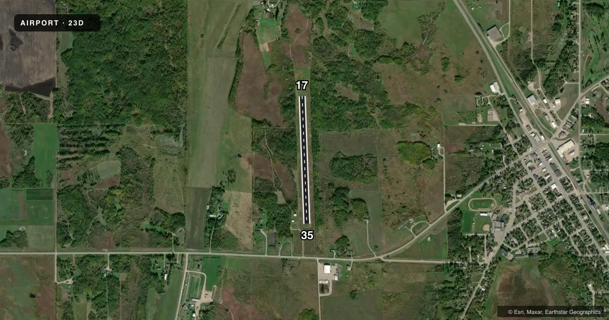
Airport sketch
Runways drawn to scale from FAA survey coordinates, rendered over satellite imagery. Not for navigation.
Approaches & charts
Services on the field
Fuel grades, oxygen, maintenance, ramp storage and lighting — as declared to the FAA by the airport operator.
Fuel & services
- Fuel
- Not available
- Oxygen (bottled)
- Not available
- Oxygen (bulk)
- Not available
- Airframe repair
- Not available
- Power plant repair
- Not available
Ramp & ground
- Transient storage
- Tie-down
- Landing fee
- No fee published
- Lighting schedule
- SS-SR
- Wind indicator
- Lighted
- Segmented circle
- No
Fuel & FBOs
Cheapest 100LL and Jet A on the field and nearby. Always confirm with the FBO before taxi.
Airport notes
Surface conditions, obstructions, local procedures, lighting outages and other notes published with each FAA cycle.
General notes
- RUTS IN RAMP.
- FOR CD CTC MINNEAPOLIS ARTCC AT 651-463-5588.
Runway surface & condition
- 17/35NSTD LIRL DUE TO 400 FT BTN LGTS.
Approach & departure obstructions
- 17YELLOW CONES.
- 35YELLOW CONES.
- 35RY 35 ROAD: SIGNS POSTED TO CONTROL TFC.
- 17NMRS APCH SFC PENETRATIONS.
Other notes
- ESTABD BFR 1959.
VFR map & nearby airports
VFR sectional. Tap any ICAO chip to open that airport.
Key facts · 23D
Answer card- ICAO
- 23D
- Name
- KARLSTAD MUNI
- Location
- KARLSTAD, MINNESOTA
- Elevation
- 1,025 ft MSL
- Traffic pattern altitude
- 2,025 ft MSL (1,000 AGL)
- Control tower
- Non-towered (use CTAF)
- Total runways
- 1
- Longest runway
- 17/35 · 2,606 ft
- Published ILS approaches
- 0
- Published frequencies
- 1
- Magnetic variation
- 6°
- Current flight rules
- VFR
- Current wind
- 310° at 6 kt
- Favored runway now
- RWY 35
Karlstad Muni sits in Karlstad, Minnesota. The field elevation is 1,025 ft MSL. It has one runway, 17/35, at 2,606 ft. There is no control tower. CTAF is 122.9. No ILS approaches are published here.
The published pattern altitude is not listed, so use the standard 1,000 ft AGL for light piston traffic unless the current Chart Supplement says otherwise. That puts the pattern at 2,025 ft MSL based on the field elevation. Verify before you fly. There are no on-field FBOs listed, so plan on self-sufficiency and contact the airport operator or the field by radio for current services.
A few remarks matter here. Runway 35 has signs posted to control road traffic. Yellow cones mark the ends of both runways. The runway lights are nonstandard low intensity because the lights are spaced 400 ft apart. There are also ruts in the ramp. Runway 17 has numerous approach surface penetrations, so pay close attention on arrival and departure. For clearance delivery, Minneapolis ARTCC can be reached at 651-463-5588. This is a turf strip with a short runway, so check density, surface condition and wind before committing.