METAR & TAF KPMB
KPMB does not publish a METAR.
Showing the nearest reporting station: KHCO (HALLOCK MUNI) · 16.4 NM away. Conditions at KPMB may differ.
METAR · KHCO
Observed 18:35Z
KHCO 271835Z AUTO 31006KT 10SM BKN020 27/24 A2981 RMK AO2
- Wind
- 310° @ 6 kt
- Visibility
- 10 SM
- Temp / Dew
- 27°C / 24°C
- Altimeter
- 29.81 inHg
- Clouds
- BKN
- Density alt
- 2,563 ft
- Ceiling
- 2,000 ft AGL
- Rules
- MVFR
Airport info & contacts
Manager on record, flight service, ARTCC, attendance schedule and pattern altitude — published by the FAA and refreshed every 28 days.
Location
- From city
- 1 NM S
- VFR sectional
- TWIN CITIES
- ARTCC
- ZMP · MINNEAPOLIS
- NOTAM facility
- GFK (NOTAM-D)
Airport manager
- Name
- TERRY NORD
- Phone
- 701-331-4458
- Address
- 10597 OLD HWY 81, PEMBINA ND 58271
Flight service · Hours
- FSS GFK
- GRAND FORKS1-800-WX-BRIEF
- Attendance
- ALL
Frequencies
Tap any row to copy the frequency to your clipboard.
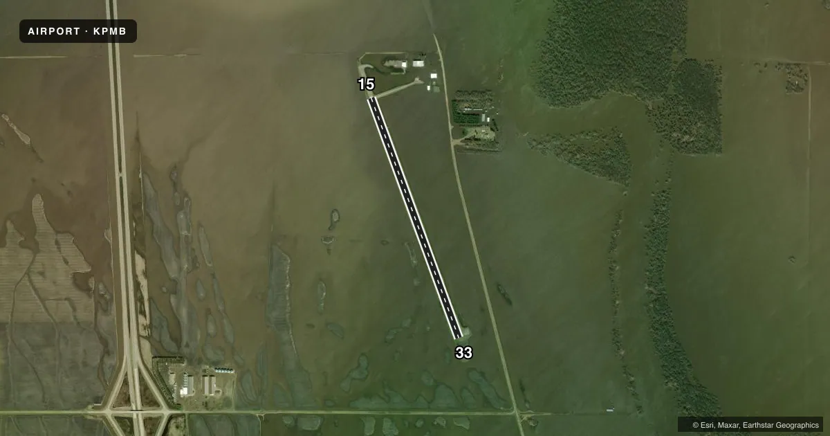
Runways & pattern
Full pagePattern entry · RWY 33
LEFT TRAFFICRunway end performance
| End | TORA | TODA | ASDA | LDA | VGSI | Approach lights | Obstruction |
|---|---|---|---|---|---|---|---|
| 15 | — | — | — | — | PAPI 2-box left(3°) | — | — |
| 33 | — | — | — | — | PAPI 2-box left(3°) | — | — |
Declared distances in feet. TORA = takeoff run available, TODA = takeoff distance, ASDA = accelerate-stop, LDA = landing distance.
Airport sketch
Runways drawn to scale from FAA survey coordinates, rendered over satellite imagery. Not for navigation.
Approaches & charts
Services on the field
Fuel grades, oxygen, maintenance, ramp storage and lighting — as declared to the FAA by the airport operator.
Fuel & services
- Fuel
- 100LL
- Airframe repair
- Major
- Power plant repair
- Major
- Other services
- AGRI,CHTR,INSTR
Ramp & ground
- Transient storage
- Tie-down
- Hangar
- Landing fee
- No fee published
- Customs
- Available
- Lighting schedule
- SEE RMK
- Beacon schedule
- SS-SR
- Beacon
- White / Green (civil land)(WG)
- Wind indicator
- Lighted
- Segmented circle
- No
Fuel & FBOs
Cheapest 100LL and Jet A on the field and nearby. Always confirm with the FBO before taxi.
Airport notes
Surface conditions, obstructions, local procedures, lighting outages and other notes published with each FAA cycle.
General notes
- CFM WINTER CONDS & SN REMOVAL BFR USE, CALL 701-331-4458 OR 701-825-6615.
- RWY 15/33 TWY TO APRON MKD WITH REFLECTORS.
- FOR CD CTC MINNEAPOLIS ARTCC AT 651-463-5588.
- BIRDS & DEER ON & INVOF ARPT.
Lighting notes
- ACTVT MIRL RWY 15/33; PAPI RWY 15 & 33 - CTAF.
Fuel notes
- 100LLFUEL SVC H24 PRVDD BY AMGR FUEL TRUCK.
Runway surface & condition
- 15/33500 FT STOPWAY NORTH END.
Other notes
- 1FOR SVCS CTC AMGR.
- OWNERCHAIRMAN OF ARPT AUTH; MARK HATLOY 701-520-1841.
VFR map & nearby airports
VFR sectional. Tap any ICAO chip to open that airport.
Key facts · KPMB
Answer card- ICAO
- KPMB
- Name
- PEMBINA MUNI
- Location
- PEMBINA, NORTH DAKOTA
- Elevation
- 795.8 ft MSL
- Traffic pattern altitude
- 1,795.8 ft MSL (1,000 AGL)
- Control tower
- Non-towered (use CTAF)
- Total runways
- 1
- Longest runway
- 15/33 · 3,798 ft
- Published ILS approaches
- 0
- Published frequencies
- 2
- Magnetic variation
- 3°
- Current flight rules
- MVFR
- Current wind
- 310° at 6 kt
- Favored runway now
- RWY 33
Pembina Muni is in Pembina, North Dakota. Field elevation is 795.8 ft MSL. The airport has one runway. Runway 15/33 is 3,798 ft long and asphalt. There is no control tower. CTAF and UNICOM are both 122.8. No ILS approaches are published here, so plan with the current chart and weather before you go.
The published pattern altitude is not listed. Use the standard 1,000 ft AGL pattern unless local procedures or the current Chart Supplement say otherwise. Nord Aviation is on the field. It carries 100LL. Fuel service is also listed as available 24 hours a day by the airport manager's fuel truck. The runway has medium intensity lights. PAPI is available on runways 15 and 33. There is a 500 foot stopway at the north end of runway 15/33.
For a first-time arrival, winter conditions matter here. The Chart Supplement remarks say to confirm snow removal before use. Birds and deer are also reported on and near the airport. The taxiway to the apron from runway 15/33 is marked with reflectors. For clearance delivery, contact Minneapolis ARTCC. This is a non-towered field, so expect self-announced traffic on 122.8 and keep an eye out for local traffic on the runway and taxiway.