METAR & TAF D29
D29 does not publish a METAR.
Showing the nearest reporting station: KHCO (HALLOCK MUNI) · 12.3 NM away. Conditions at D29 may differ.
METAR · KHCO
Observed 21:35Z
KHCO 272135Z AUTO 31007KT 10SM SCT031 29/24 A2982 RMK AO2
- Wind
- 310° @ 7 kt
- Visibility
- 10 SM
- Temp / Dew
- 29°C / 24°C
- Altimeter
- 29.82 inHg
- Clouds
- SCT
- Density alt
- 2,794 ft
- Ceiling
- Unlimited
- Rules
- VFR
Airport info & contacts
Manager on record, flight service, ARTCC, attendance schedule and pattern altitude — published by the FAA and refreshed every 28 days.
Location
- From city
- 3 NM N
- VFR sectional
- TWIN CITIES
- ARTCC
- ZMP · MINNEAPOLIS
- NOTAM facility
- GFK (NOTAM-D)
Airport manager
- Name
- ROB BOLL
- Phone
- 701-520-1219
- Address
- BOX 280, DRAYTON ND 58225
Flight service · Hours
- FSS GFK
- GRAND FORKS1-800-WX-BRIEF
- Attendance
- Unattended
Frequencies
Tap any row to copy the frequency to your clipboard.
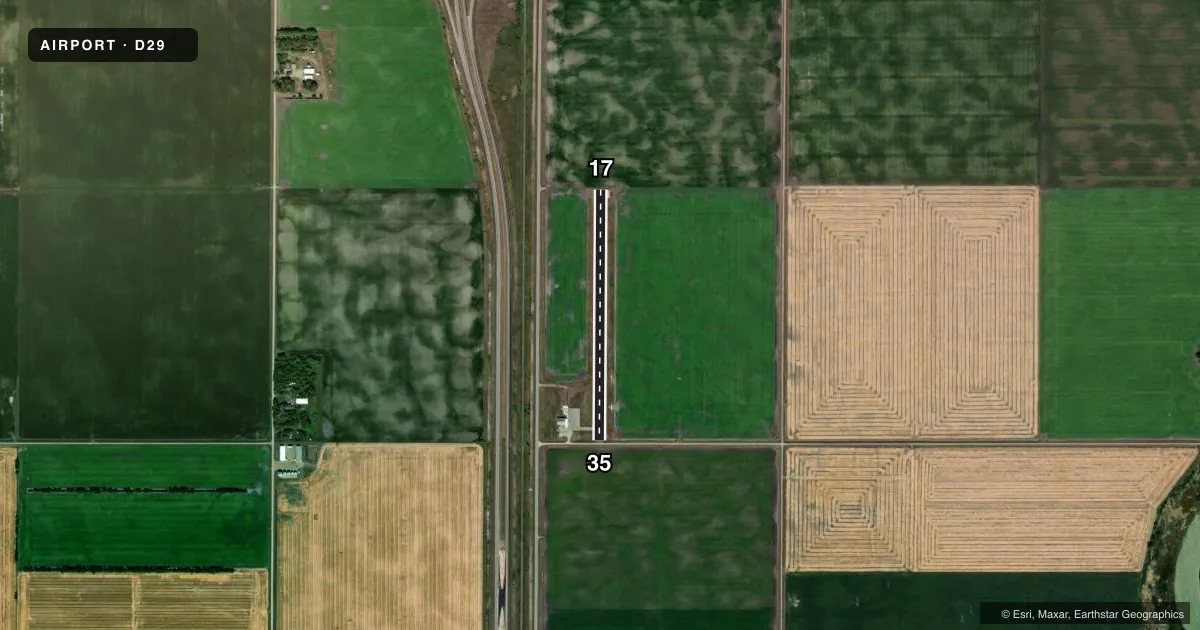
Runways & pattern
Full pagePattern entry · RWY 35
LEFT TRAFFICAirport sketch
Runways drawn to scale from FAA survey coordinates, rendered over satellite imagery. Not for navigation.
Approaches & charts
Services on the field
Fuel grades, oxygen, maintenance, ramp storage and lighting — as declared to the FAA by the airport operator.
Fuel & services
- Fuel
- Not available
- Other services
- AGRI
Ramp & ground
- Transient storage
- Tie-down
- Landing fee
- No fee published
- Lighting schedule
- SEE RMK
- Beacon schedule
- SS-SR
- Beacon
- White / Green (civil land)(WG)
- Wind indicator
- Lighted
- Segmented circle
- No
Fuel & FBOs
Cheapest 100LL and Jet A on the field and nearby. Always confirm with the FBO before taxi.
Airport notes
Surface conditions, obstructions, local procedures, lighting outages and other notes published with each FAA cycle.
General notes
- CFM WINTER CONDS AND SN REMOVAL BFR USE, CALL 701-454-3590 OR 701-454-6588.
- FOR CD CTC MINNEAPOLIS ARTCC AT 651-463-5588.
- RWY 17 CULTIVATED FLD 20 FT FM THR.
Lighting notes
- LIRL RY 17/35 OPER DUSK-2400; AFTER 2400 HR ACTVT LIRL RWY 17/35-CTAF
Approach & departure obstructions
- 35+16' E-W ROAD 25' FRM THLD & 4' DITCH 60' FRM THLD.
- 35DSPLCD THR - NGT OPNS ONLY.
- 17MKGS HEAVILY WORN & FADED.
- 35MKGS HEAVILY WORN & FADED.
- 172 FT DROPOFF 5 FT FM THLD.
- 3516 FT ROAD 530 FT FM DSPLCD THLD.
Other notes
- 1FOR SVC CALL 701-454-6588.
- MANAGERADDNL CTC IS CITY HALL AT 701-454-3590 OR TROY GEORGESON AT 701-454-6588.
- MANAGERAMGR 701-454-3317.
VFR map & nearby airports
VFR sectional. Tap any ICAO chip to open that airport.
Key facts · D29
Answer card- ICAO
- D29
- Name
- DRAYTON MUNI
- Location
- DRAYTON, NORTH DAKOTA
- Elevation
- 798 ft MSL
- Traffic pattern altitude
- 1,798 ft MSL (1,000 AGL)
- Control tower
- Non-towered (use CTAF)
- Total runways
- 1
- Longest runway
- 17/35 · 2,596 ft
- Published ILS approaches
- 0
- Published frequencies
- 1
- Magnetic variation
- 7°
- Current flight rules
- VFR
- Current wind
- 310° at 7 kt
- Favored runway now
- RWY 35
Drayton Muni (D29) sits in Drayton, North Dakota. Field elevation is 798 ft MSL. The airport has one asphalt runway, 17/35, at 2,596 ft. There is no control tower. CTAF is 122.9.
No ILS approaches are published here. Pattern altitude is not published, so use the standard 1,000 ft AGL for light piston traffic unless the current FAA Chart Supplement says otherwise. The runway is short enough that performance planning matters, especially if you are arriving heavy or in winter conditions.
Published remarks call out several operational items. Runway 17 and runway 35 markings are heavily worn. Runway 35 has a displaced threshold for night operations only. Runway 17 has a cultivated field close to the threshold. There is also a road and ditch near the runway 35 end. Low intensity runway lights on 17/35 operate from dusk to 2400 hours. After 2400 hours, activate the lights via CTAF.
No on-field FBOs are listed. Confirm winter conditions and snow removal before use by calling the airport contacts or the airport manager. For clearance delivery, contact Minneapolis ARTCC at 651-463-5588. If you are planning a first stop here, review the current Chart Supplement and brief the runway end details before you go.