METAR & TAF D06
D06 does not publish a METAR.
Showing the nearest reporting station: KGAF (HUTSON FLD) · 6.8 NM away. Conditions at D06 may differ.
METAR · KGAF
Observed 16:35Z
KGAF 271635Z AUTO 34008G15KT 9SM CLR 28/22 A2980 RMK AO2 PWINO
- Wind
- 340° @ 8G15 kt
- Visibility
- 9 SM
- Temp / Dew
- 28°C / 22°C
- Altimeter
- 29.80 inHg
- Clouds
- CLR
- Density alt
- 2,726 ft
- Ceiling
- Unlimited
- Rules
- VFR
Airport info & contacts
Manager on record, flight service, ARTCC, attendance schedule and pattern altitude — published by the FAA and refreshed every 28 days.
Location
- From city
- 1 NM W
- VFR sectional
- TWIN CITIES
- ARTCC
- ZMP · MINNEAPOLIS
- NOTAM facility
- GFK (NOTAM-D)
Airport manager
- Name
- TREVOR SLOMINSKI
- Phone
- 701-248-3784
- Address
- BOX 280, MINTO ND 58261
Flight service · Hours
- FSS GFK
- GRAND FORKS1-800-WX-BRIEF
- Attendance
- MAY-SEP · 0800-1700
- OCT-APR · ON CALL
Frequencies
Tap any row to copy the frequency to your clipboard.
Runways & pattern
Full pagePattern entry · RWY 35
LEFT TRAFFICRunway end performance
| End | TORA | TODA | ASDA | LDA | VGSI | Approach lights | Obstruction |
|---|---|---|---|---|---|---|---|
| 17 | — | — | — | — | — | — | 10', trees, 330' from thr, 40' R of cntrln, slope 13 |
Declared distances in feet. TORA = takeoff run available, TODA = takeoff distance, ASDA = accelerate-stop, LDA = landing distance.
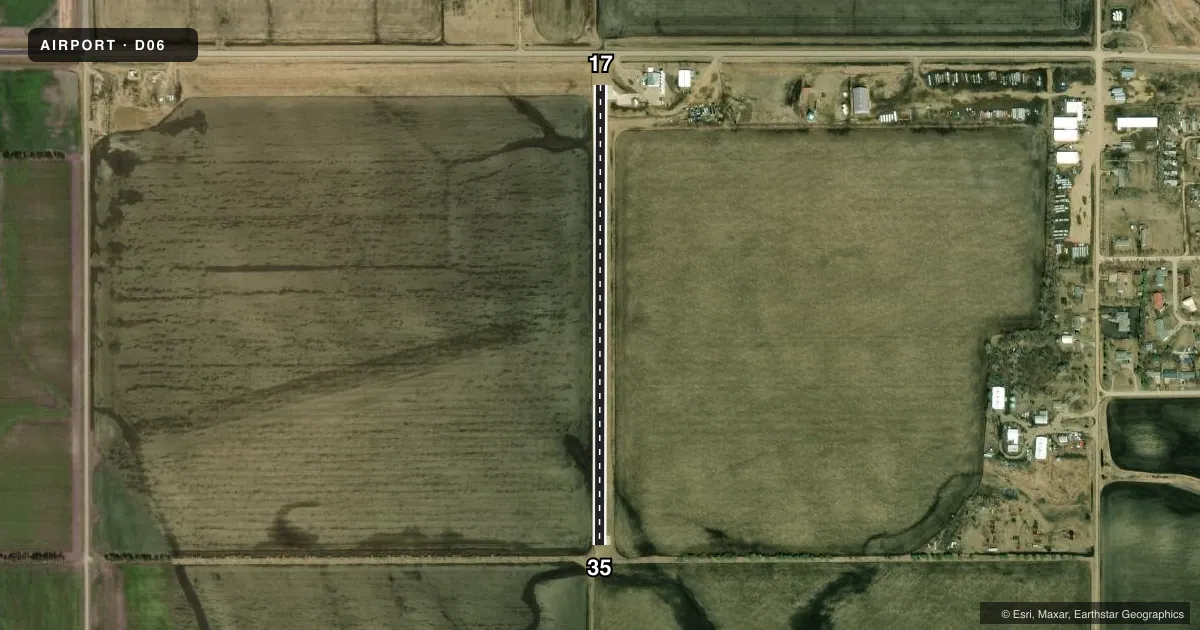
Airport sketch
Runways drawn to scale from FAA survey coordinates, rendered over satellite imagery. Not for navigation.
Approaches & charts
Services on the field
Fuel grades, oxygen, maintenance, ramp storage and lighting — as declared to the FAA by the airport operator.
Fuel & services
- Fuel
- Not available
- Oxygen (bottled)
- Not available
- Oxygen (bulk)
- Not available
- Airframe repair
- Not available
- Power plant repair
- Not available
- Other services
- AGRI
Ramp & ground
- Transient storage
- Tie-down
- Landing fee
- No fee published
- Wind indicator
- Yes
- Segmented circle
- No
Fuel & FBOs
Cheapest 100LL and Jet A on the field and nearby. Always confirm with the FBO before taxi.
Airport notes
Surface conditions, obstructions, local procedures, lighting outages and other notes published with each FAA cycle.
General notes
- CFM WINTER COND & SNOW REMOVAL BEFORE USE 701-248-3978 OR 218-779-7940.
- ARPT CLSD IN WINTER MONTHS EXCEPT PPR CTC AMGR 701-248-3978 OR 218-779-7940.
- FOR CD CTC MINNEAPOLIS ARTCC AT 651-463-5588.
Approach & departure obstructions
- 17+18 FT ROAD 160 FT FM RY 17 THLD ON CNTRLN.
- 357FT CORN FLDS MAY-OCT 80 FT EAST & 120 FT SOUTH OF THR. CLNC SLP 0:1 WHEN PRESENT.
Other notes
- 17/35CONC SFC 2396 FT BY 20 FT; TURF SFC 2250 FT BY 40 FT EXISTS IMT E OF CONC RWY SOFT WHEN WET.
VFR map & nearby airports
VFR sectional. Tap any ICAO chip to open that airport.
Key facts · D06
Answer card- ICAO
- D06
- Name
- MINTO MUNI
- Location
- MINTO, NORTH DAKOTA
- Elevation
- 820 ft MSL
- Traffic pattern altitude
- 1,820 ft MSL (1,000 AGL)
- Control tower
- Non-towered (use CTAF)
- Total runways
- 1
- Longest runway
- 17/35 · 2,396 ft
- Published ILS approaches
- 0
- Published frequencies
- 1
- Magnetic variation
- 6°
- Current flight rules
- VFR
- Current wind
- 340° at 8 kt
- Favored runway now
- RWY 35
Minto Muni (D06) sits in Minto, North Dakota at 820 ft MSL. It has one runway. The longest is 2,396 ft. There is no control tower. CTAF is 122.9. No ILS approaches are published here.
Runway 17/35 is concrete, 2,396 ft by 20 ft. A turf surface also exists immediately east of the concrete runway. It is 2,250 ft by 40 ft. The turf can be soft when wet. There is an 18-foot road 160 feet from the runway 17 threshold on the centerline. Near runway 35, seven-foot cornfields can sit close to the threshold from May through October. The published clearance slope there is zero to one when the crops are present.
Pattern altitude is not published. Use the standard 1,000 ft AGL pattern unless the current Chart Supplement says otherwise. For clearance delivery, contact Minneapolis ARTCC. Winter use needs extra attention. The airport is closed in winter months except by prior permission. Confirm snow removal and current field conditions before you go. There are no on-field FBOs listed. Call the airport manager directly before arrival if you need current services. This is a small field with limited runway length, seasonal surface issues and nearby obstructions. Plan accordingly.