METAR & TAF D41
D41 does not publish a METAR.
Showing the nearest reporting station: KHCO (HALLOCK MUNI) · 18.0 NM away. Conditions at D41 may differ.
METAR · KHCO
Observed 20:55Z
KHCO 272055Z AUTO 29005KT 10SM CLR 29/24 A2980 RMK AO2
- Wind
- 290° @ 5 kt
- Visibility
- 10 SM
- Temp / Dew
- 29°C / 24°C
- Altimeter
- 29.80 inHg
- Clouds
- CLR
- Density alt
- 2,858 ft
- Ceiling
- Unlimited
- Rules
- VFR
Airport info & contacts
Manager on record, flight service, ARTCC, attendance schedule and pattern altitude — published by the FAA and refreshed every 28 days.
Location
- From city
- 1 NM NE
- VFR sectional
- TWIN CITIES
- Pattern altitude
- 800 ft AGL · 1,630 ft MSL
- ARTCC
- ZMP · MINNEAPOLIS
- NOTAM facility
- PNM (NOTAM-D)
Airport manager
- Name
- KIRK LARSON
- Phone
- 218-478-2247
- Address
- 40214 380TH ST. NW, PO BOX 139, STEPHEN MN 56757
Flight service · Hours
- FSS PNM
- PRINCETON1-800-WX-BRIEF
- Attendance
- MON-FRI · DALGT
Frequencies
Tap any row to copy the frequency to your clipboard.
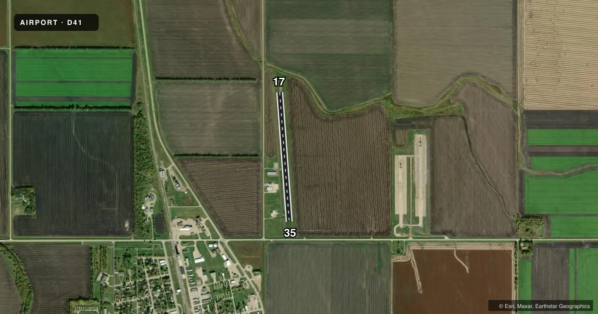
Runways & pattern
Full pagePattern entry · RWY 35
LEFT TRAFFICRunway end performance
| End | TORA | TODA | ASDA | LDA | VGSI | Approach lights | Obstruction |
|---|---|---|---|---|---|---|---|
| 35 | — | — | — | — | — | — | 17', road, 482' from thr, 0' R of cntrln, slope 16 |
Declared distances in feet. TORA = takeoff run available, TODA = takeoff distance, ASDA = accelerate-stop, LDA = landing distance.
Airport sketch
Runways drawn to scale from FAA survey coordinates, rendered over satellite imagery. Not for navigation.
Approaches & charts
Services on the field
Fuel grades, oxygen, maintenance, ramp storage and lighting — as declared to the FAA by the airport operator.
Fuel & services
- Fuel
- Not available
- Other services
- AGRI
Ramp & ground
- Transient storage
- Hangar
- Landing fee
- No fee published
- Customs
- Not available
- Lighting schedule
- SS-SR
- Beacon schedule
- SS-SR
- Beacon
- White / Green (civil land)(WG)
- Wind indicator
- Lighted
- Segmented circle
- No
Fuel & FBOs
Cheapest 100LL and Jet A on the field and nearby. Always confirm with the FBO before taxi.
Airport notes
Surface conditions, obstructions, local procedures, lighting outages and other notes published with each FAA cycle.
General notes
- ANTENNA 1.85 SM SE, 1,258 FT MSL (418 FT AGL)
- FOR CD CTC MINNEAPOLIS ARTCC AT 651-463-5588.
Other notes
- PRVD THR ARE LOCATED AND CLEARLY MKD SO AS TO PRVD A MINIMUM 20:1 CLNC OVER ALL OBSTN.
VFR map & nearby airports
VFR sectional. Tap any ICAO chip to open that airport.
Key facts · D41
Answer card- ICAO
- D41
- Name
- STEPHEN MUNI
- Location
- STEPHEN, MINNESOTA
- Elevation
- 830 ft MSL
- Traffic pattern altitude
- 1,630 ft MSL (800 AGL)
- Control tower
- Non-towered (use CTAF)
- Total runways
- 1
- Longest runway
- 17/35 · 2,700 ft
- Published ILS approaches
- 0
- Published frequencies
- 2
- Magnetic variation
- 6°
- Current flight rules
- VFR
- Current wind
- 290° at 5 kt
- Favored runway now
- RWY 35
Stephen Muni Airport (D41) sits in Stephen, Minnesota. Field elevation is 830 ft MSL. The airport has one runway. Runway 17/35 is 2,700 ft long with an asphalt surface. There is no control tower. CTAF and UNICOM are both 122.7.
Pattern altitude is 800 ft AGL. That puts the traffic pattern at 1,630 ft MSL. No ILS approaches are published here. Plan with the current charted procedures before you go.
There are no on-field FBOs listed in the facts. Contact the airport operator directly or call the field on CTAF or UNICOM for current service details before arrival. Published remarks also note an antenna 1.85 statute miles southeast of the airport. It sits at 1,258 ft MSL. That is 418 ft AGL, so keep it in mind on departure and in the local area. The Chart Supplement also says the threshold areas are marked to provide at least 20 to 1 obstacle clearance.
This is a non-towered field, so standard self-announce discipline matters. Use the published pattern altitude, watch the antenna southeast of the field and verify any clearance needs with Minneapolis ARTCC at 651-463-5588 if you need IFR release or clearance delivery support.