METAR & TAF D37
D37 does not publish a METAR.
Showing the nearest reporting station: KCKN (CROOKSTON MUNI/KIRKWOOD FLD) · 21.3 NM away. Conditions at D37 may differ.
METAR · KCKN
Observed 18:35Z
KCKN 271835Z AUTO 32006KT 10SM SCT029 31/22 A2982 RMK AO2
- Wind
- 320° @ 6 kt
- Visibility
- 10 SM
- Temp / Dew
- 31°C / 22°C
- Altimeter
- 29.82 inHg
- Clouds
- SCT
- Density alt
- 3,145 ft
- Ceiling
- Unlimited
- Rules
- VFR
Airport info & contacts
Manager on record, flight service, ARTCC, attendance schedule and pattern altitude — published by the FAA and refreshed every 28 days.
Location
- From city
- 2 NM E
- VFR sectional
- TWIN CITIES
- ARTCC
- ZMP · MINNEAPOLIS
- NOTAM facility
- PNM (NOTAM-D)
Airport manager
- Name
- AARON PETERSON
- Phone
- (218) 201-0652
- Address
- 120 E. BRIDGE AVE., WARREN MN 56762
Flight service · Hours
- FSS PNM
- PRINCETON1-800-WX-BRIEF
- Attendance
- MAY-OCT · SAT-SUN · 0800-1700
Frequencies
Tap any row to copy the frequency to your clipboard.
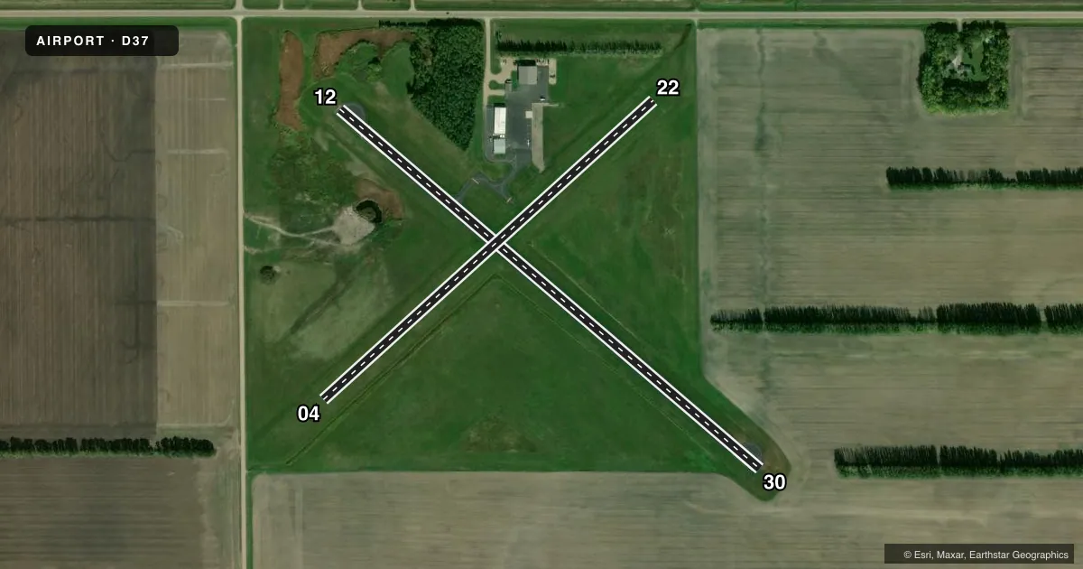
Runways & pattern
Full pagePattern entry · RWY 30
LEFT TRAFFIC| Runway | Heading (°M) | Length | Surface | Traffic |
|---|---|---|---|---|
| 12/30Favored | 125° / 305° | 3,199 ft | ASPH | Standard L |
| 04/22 | 43° / 223° | 2,578 ft | TURF | Standard L |
Runway end performance
| End | TORA | TODA | ASDA | LDA | VGSI | Approach lights | Obstruction |
|---|---|---|---|---|---|---|---|
| 12 | 3,199' | 3,199' | 3,199' | 3,009' | — | — | 18', road, 507' from thr, 266' R of cntrln, slope 17 |
| 30 | 3,199' | 3,199' | 3,199' | 3,199' | — | — | — |
Declared distances in feet. TORA = takeoff run available, TODA = takeoff distance, ASDA = accelerate-stop, LDA = landing distance.
Airport sketch
Runways drawn to scale from FAA survey coordinates, rendered over satellite imagery. Not for navigation.
Approaches & charts
Services on the field
Fuel grades, oxygen, maintenance, ramp storage and lighting — as declared to the FAA by the airport operator.
Fuel & services
- Fuel
- Not available
- Other services
- AGRI,SALES
Ramp & ground
- Transient storage
- Tie-down
- Hangar
- Landing fee
- No fee published
- Customs
- Not available
- Lighting schedule
- SS-SR
- Beacon schedule
- SS-SR
- Beacon
- White / Green (civil land)(WG)
- Wind indicator
- Lighted
- Segmented circle
- No
Fuel & FBOs
Cheapest 100LL and Jet A on the field and nearby. Always confirm with the FBO before taxi.
Airport notes
Surface conditions, obstructions, local procedures, lighting outages and other notes published with each FAA cycle.
General notes
- DEER & GEESE ON & INVOF ARPT.
- TOWER 4 'WNW', 1248 FT MSL (400 FT AGL).
- FOR CD CTC MINNEAPOLIS ARTCC AT 651-463-5588.
Runway surface & condition
- 04/22MARKED WITH YELLOW CONES. NOT PLOWED WINTER MONTHS.
Approach & departure obstructions
- 30CALM WND RWY.
- 04MKD WITH YELLOW CONES.
- 22MKD WITH YELLOW CONES.
Other notes
- MANAGERUSE TEXT MSGG WHEN CTCG ARPT MGR.
VFR map & nearby airports
VFR sectional. Tap any ICAO chip to open that airport.
Key facts · D37
Answer card- ICAO
- D37
- Name
- WARREN MUNI
- Location
- WARREN, MINNESOTA
- Elevation
- 888.2 ft MSL
- Traffic pattern altitude
- 1,888.2 ft MSL (1,000 AGL)
- Control tower
- Non-towered (use CTAF)
- Total runways
- 2
- Longest runway
- 12/30 · 3,199 ft
- Published ILS approaches
- 0
- Published frequencies
- 4
- Magnetic variation
- 5°
- Current flight rules
- VFR
- Current wind
- 320° at 6 kt
- Favored runway now
- RWY 30
Warren Muni sits in Warren, Minnesota. Field elevation is 888.2 ft MSL. The airport has two runways. The longest is runway 12/30 at 3,199 ft asphalt. Runway 04/22 is 2,578 ft turf. This is an untowered field. CTAF and UNICOM are both 122.8. No ILS approaches are published here.
Pattern altitude is not published. Use 1,000 ft AGL for light piston planning unless the current Chart Supplement says otherwise. Clearance delivery goes through Minneapolis ARTCC at 651-463-5588. The published remarks also call out deer and geese near the airport. That matters here. Expect wildlife on or near the movement area, especially when the field is quiet.
Runway 30 is the calm wind runway. Runway 04 and runway 22 are marked with yellow cones. Runway 04/22 is not plowed during winter months. The tower noted in the remarks is a nearby obstruction at 1,248 ft MSL, 400 ft AGL. There are no on-field FBOs listed. Contact the airport operator directly before arrival, or call the field on CTAF or UNICOM for current FBO availability. If you need current noise or operating restrictions, check the current FAA Chart Supplement before you go.