METAR & TAF KCKN
Current METAR
Observed 22:55Z
KCKN 272255Z AUTO 34011KT 10SM CLR 30/22 A2984 RMK AO2
- Wind
- 340° @ 11 kt
- Visibility
- 10 SM
- Temp / Dew
- 30°C / 22°C
- Altimeter
- 29.84 inHg
- Clouds
- CLR
- Density alt
- 3,011 ft
- Ceiling
- Unlimited
- Rules
- VFR
Airport info & contacts
Manager on record, flight service, ARTCC, attendance schedule and pattern altitude — published by the FAA and refreshed every 28 days.
Location
- From city
- 4 NM N
- VFR sectional
- TWIN CITIES
- Pattern altitude
- 800 ft AGL · 1,697 ft MSL
- ARTCC
- ZMP · MINNEAPOLIS
- NOTAM facility
- CKN (NOTAM-D)
Airport manager
- Name
- LOWELL MILLER
- Phone
- 218-281-2625
- Address
- 26305 AIRPORT RD SW, CROOKSTON MN 56716-9004
Flight service · Hours
- FSS PNM
- PRINCETON1-800-WX-BRIEF
- Attendance
- MON-FRI · 0800-1700
Frequencies
Tap any row to copy the frequency to your clipboard.
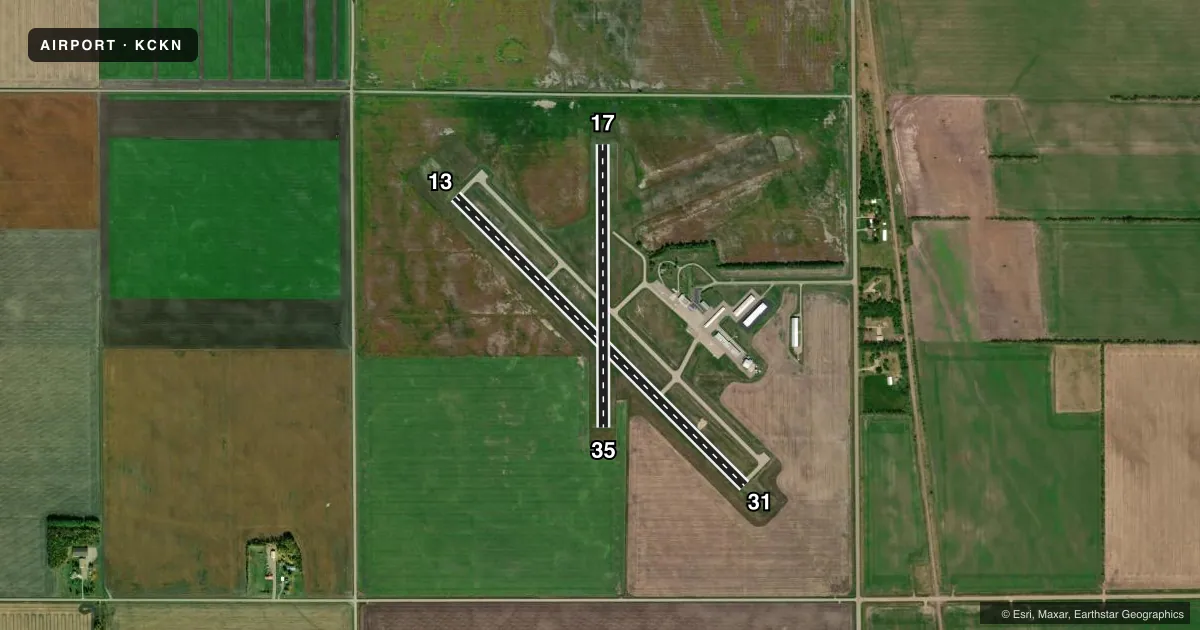
Runways & pattern
Full pagePattern entry · RWY 35
LEFT TRAFFIC| Runway | Heading (°M) | Length | Surface | Traffic |
|---|---|---|---|---|
| 13/31 | 133° / 313° | 4,300 ft | ASPH | Standard L |
| 17/35Favored | 178° / 358° | 2,977 ft | TURF | Standard L |
Runway end performance
| End | TORA | TODA | ASDA | LDA | VGSI | Approach lights | Obstruction |
|---|---|---|---|---|---|---|---|
| 13 | — | — | — | — | PAPI 4-box left(3°) | — | — |
| 31 | — | — | — | — | PAPI 4-box right(3°) | — | — |
Declared distances in feet. TORA = takeoff run available, TODA = takeoff distance, ASDA = accelerate-stop, LDA = landing distance.
Airport sketch
Runways drawn to scale from FAA survey coordinates, rendered over satellite imagery. Not for navigation.
Approaches & charts
Services on the field
Fuel grades, oxygen, maintenance, ramp storage and lighting — as declared to the FAA by the airport operator.
Fuel & services
- Fuel
- 100LLA
- Oxygen (bottled)
- Not available
- Oxygen (bulk)
- Not available
- Airframe repair
- Major
- Power plant repair
- Major
- Other services
- AGRI,INSTR,RNTL,SALES
Ramp & ground
- Transient storage
- Tie-down
- Hangar
- Landing fee
- No fee published
- Customs
- Not available
- Lighting schedule
- SEE RMK
- Beacon schedule
- SS-SR
- Beacon
- White / Green (civil land)(WG)
- Wind indicator
- Lighted
- Segmented circle
- No
Fuel & FBOs
Cheapest 100LL and Jet A on the field and nearby. Always confirm with the FBO before taxi.
Airport notes
Surface conditions, obstructions, local procedures, lighting outages and other notes published with each FAA cycle.
General notes
- FOR CD CTC MINNEAPOLIS ARTCC AT 651-463-5588.
Lighting notes
- ACTVT REIL RWY 13 & 31; PAPI RWY 13; MIRL RWY 13/31 - CTAF. PAPI RWY 31 OPR CONSLY.
Fuel notes
- 100LLFUEL AVBL H24 VIA CREDIT CARD.
Runway surface & condition
- 17/35NOT PLOWED WINTER MONTHS.
Approach & departure obstructions
- 13CALM WIND RWY.
- 17YELLOW CONES.
- 35YELLOW CONES.
Other notes
- 1FOR SVC AFT HRS CALL 218-693-1095.
VFR map & nearby airports
VFR sectional. Tap any ICAO chip to open that airport.
Key facts · KCKN
Answer card- ICAO
- KCKN
- Name
- CROOKSTON MUNI/KIRKWOOD FLD
- Location
- CROOKSTON, MINNESOTA
- Elevation
- 896.7 ft MSL
- Traffic pattern altitude
- 1,696.7 ft MSL (800 AGL)
- Control tower
- Non-towered (use CTAF)
- Total runways
- 2
- Longest runway
- 13/31 · 4,300 ft
- Published ILS approaches
- 0
- Published frequencies
- 4
- Magnetic variation
- 2°
- Current flight rules
- VFR
- Current wind
- 340° at 11 kt
- Favored runway now
- RWY 35
Crookston Muni/Kirkwood Fld sits in Crookston, Minnesota. Field elevation is 896.7 ft MSL. The airport has two runways. The longest is 4,300 ft asphalt runway 13/31. Runway 17/35 is turf and measures 2,977 ft. There is no control tower. CTAF and UNICOM are both 122.7. Approach and departure service is handled by Grand Forks on 118.1 and 318.1. No ILS approaches are published here.
Pattern altitude is 800 ft AGL. That puts the traffic pattern at 1,696.7 ft MSL. Runway 13 is listed as the calm wind runway. Runways 13 and 31 have medium intensity runway lights that are controlled by CTAF. Runway end identifier lights are installed on 13 and 31. PAPI is installed on runway 13. PAPI on runway 31 operates continuously.
Crookston Aviation is on the field. It carries 100LL and Jet A with Prist. Fuel is available 24 hours a day by credit card. Runway 17/35 is not plowed during winter months. Runway 17 and runway 35 are marked with yellow cones. For after-hours service, call the number in the Chart Supplement. If you need clearance delivery, contact Minneapolis ARTCC. First-time visitors should plan for an uncontrolled field with winter runway limits and use the published lighting and pattern data before arrival.