METAR & TAF D14
D14 does not publish a METAR.
Showing the nearest reporting station: KFSE (FOSSTON MUNI/ANDERSON FLD) · 21.2 NM away. Conditions at D14 may differ.
METAR · KFSE
Observed 02:55Z
KFSE 140255Z AUTO RMK AO2 PWINO
- Wind
- Calm
- Visibility
- —
- Temp / Dew
- —
- Altimeter
- —
- Clouds
- Clear
- Density alt
- —
- Ceiling
- Unlimited
- Rules
- VFR
Airport info & contacts
Manager on record, flight service, ARTCC, attendance schedule and pattern altitude — published by the FAA and refreshed every 28 days.
Location
- From city
- 1 NM NW
- VFR sectional
- TWIN CITIES
- ARTCC
- ZMP · MINNEAPOLIS
- NOTAM facility
- PNM (NOTAM-D)
Airport manager
- Name
- LISA LIDEN
- Phone
- 218-945-3136
- Address
- PO BOX 628, FERTILE MN 56540
Flight service · Hours
- FSS PNM
- PRINCETON1-800-WX-BRIEF
- Attendance
- Unattended
Frequencies
Tap any row to copy the frequency to your clipboard.
Runways & pattern
Full pagePattern entry · RWY 14
LEFT TRAFFICRunway end performance
| End | TORA | TODA | ASDA | LDA | VGSI | Approach lights | Obstruction |
|---|---|---|---|---|---|---|---|
| 14 | — | — | — | — | PAPI 2-box left(3.2°) | — | — |
| 32 | — | — | — | — | PAPI 2-box left(3.7°) | — | — |
Declared distances in feet. TORA = takeoff run available, TODA = takeoff distance, ASDA = accelerate-stop, LDA = landing distance.
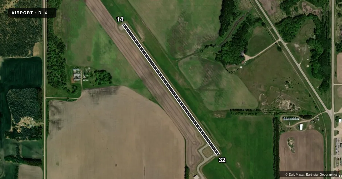
Airport sketch
Runways drawn to scale from FAA survey coordinates, rendered over satellite imagery. Not for navigation.
Approaches & charts
Services on the field
Fuel grades, oxygen, maintenance, ramp storage and lighting — as declared to the FAA by the airport operator.
Fuel & services
- Fuel
- 100LL
- Oxygen (bottled)
- Not available
- Oxygen (bulk)
- Not available
- Airframe repair
- Not available
- Power plant repair
- Not available
- Other services
- AGRI
Ramp & ground
- Transient storage
- Tie-down
- Landing fee
- No fee published
- Customs
- Not available
- Lighting schedule
- SEE RMK
- Beacon schedule
- SS-SR
- Beacon
- White / Green (civil land)(WG)
- Wind indicator
- Lighted
- Segmented circle
- No
Fuel & FBOs
Cheapest 100LL and Jet A on the field and nearby. Always confirm with the FBO before taxi.
Airport notes
Surface conditions, obstructions, local procedures, lighting outages and other notes published with each FAA cycle.
General notes
- BE ALERT FOR VEHICLE TRAFFIC ON TAXIWAYS.
- FOR CD CTC MINNEAPOLIS ARTCC AT 651-463-5588.
Lighting notes
- ACTVT PAPI RWY 14 & 32 - CTAF. MIRL RWY 14/32 TO INCR INTST & ACTVT - CTAF.
Fuel notes
- 100LLFUEL AVAILABLE 24 HR WITH CREDIT CARD.
Other notes
- PRVDD OBSTNS IN RWY APCH SLOPE SFCS WHICH CANNOT BE RMVD/LWRD, THE RWY THRS ARE DSPLCD/MRKD TO PRVD MIN 20:1 APCH CLRNC OVER OBSTNS & SUFFICIENT RMNG LENGTH TO PERMIT SAFE LNDG/TKOF BY TYPE OF ACFT USING RWY.
- MANAGERPHONE AT ARPT 218-945-6516.
VFR map & nearby airports
VFR sectional. Tap any ICAO chip to open that airport.
Key facts · D14
Answer card- ICAO
- D14
- Name
- FERTILE MUNI
- Location
- FERTILE, MINNESOTA
- Elevation
- 1,136.7 ft MSL
- Traffic pattern altitude
- 2,136.7 ft MSL (1,000 AGL)
- Control tower
- Non-towered (use CTAF)
- Total runways
- 1
- Longest runway
- 14/32 · 3,000 ft
- Published ILS approaches
- 0
- Published frequencies
- 4
- Magnetic variation
- 5°
- Current flight rules
- VFR
- Current wind
- Calm / unavailable
- Favored runway now
- –
Fertile Muni is in Fertile, Minnesota. The field elevation is 1,136.7 ft MSL. It has one runway, 14/32, which is 3,000 ft long and asphalt. There is no control tower. No ILS approaches are published. The pattern altitude is not published, so use the standard 1,000 ft AGL for light piston traffic unless current local guidance says otherwise.
The on-field FBO is Fertile Municipal Airport. It carries AVGAS 100LL. Fuel is available 24 hours with credit card. The airport remarks also note that runway thresholds are displaced because of obstacles in the approach surfaces. That means you should pay close attention to the usable landing distance and the displaced threshold markings before you turn final. Medium intensity runway lights for 14/32 are activated on CTAF. The PAPI for both runway directions is also activated on CTAF.
This is a non-towered field with CTAF and UNICOM on 122.8. Approach and departure service is handled by Grand Forks on 118.1 or 318.1. The airport remarks call out vehicle traffic on the taxiways, so keep your scan moving on the ground. For clearance delivery, contact Minneapolis ARTCC. If you need current noise, curfew, or operating restrictions, check the current FAA Chart Supplement or call the airport operator before you go.