METAR & TAF KFSE
Current METAR
Observed 01:35Z
KFSE 280135Z AUTO RMK AO2 PWINO
- Wind
- Calm
- Visibility
- —
- Temp / Dew
- —
- Altimeter
- —
- Clouds
- Clear
- Density alt
- —
- Ceiling
- Unlimited
- Rules
- VFR
Airport info & contacts
Manager on record, flight service, ARTCC, attendance schedule and pattern altitude — published by the FAA and refreshed every 28 days.
Location
- From city
- 1 NM NW
- VFR sectional
- TWIN CITIES
- ARTCC
- ZMP · MINNEAPOLIS
- NOTAM facility
- FSE (NOTAM-D)
Airport manager
- Name
- CASSIE HEIDE
- Phone
- 218-435-1959
- Address
- 220 1ST ST E, FOSSTON MN 56542-1337
Flight service · Hours
- FSS PNM
- PRINCETON1-800-WX-BRIEF
- Attendance
- Unattended
Frequencies
Tap any row to copy the frequency to your clipboard.
Runways & pattern
Full pagePattern entry · RWY 16
LEFT TRAFFICRunway end performance
| End | TORA | TODA | ASDA | LDA | VGSI | Approach lights | Obstruction |
|---|---|---|---|---|---|---|---|
| 16 | — | — | — | — | PAPI 4-box left(2.8°) | — | — |
| 34 | — | — | — | — | PAPI 4-box left(2.8°) | — | — |
Declared distances in feet. TORA = takeoff run available, TODA = takeoff distance, ASDA = accelerate-stop, LDA = landing distance.
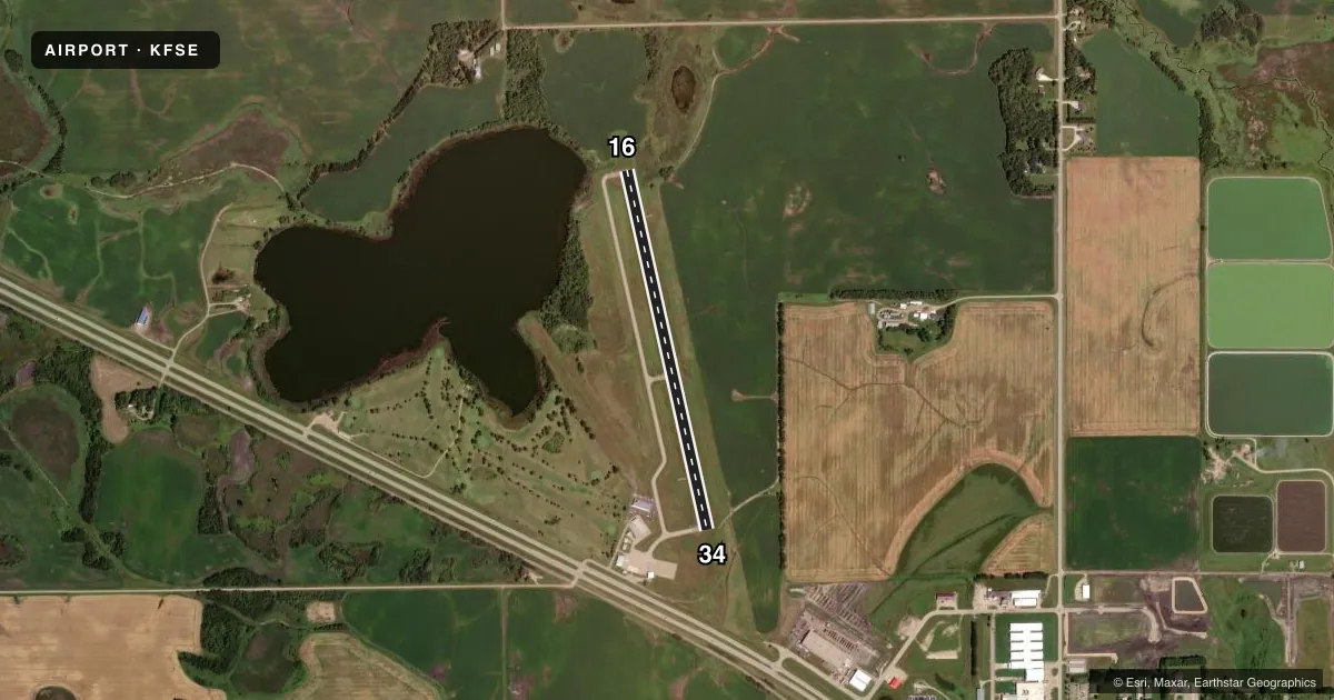
Airport sketch
Runways drawn to scale from FAA survey coordinates, rendered over satellite imagery. Not for navigation.
Approaches & charts
Services on the field
Fuel grades, oxygen, maintenance, ramp storage and lighting — as declared to the FAA by the airport operator.
Fuel & services
- Fuel
- 100LL
- Oxygen (bottled)
- Not available
- Oxygen (bulk)
- Not available
- Airframe repair
- Not available
- Power plant repair
- Not available
- Other services
- AGRI
Ramp & ground
- Transient storage
- Tie-down
- Landing fee
- No fee published
- Customs
- Not available
- Lighting schedule
- SEE RMK
- Beacon schedule
- SS-SR
- Beacon
- White / Green (civil land)(WG)
- Wind indicator
- Lighted
- Segmented circle
- No
Fuel & FBOs
Cheapest 100LL and Jet A on the field and nearby. Always confirm with the FBO before taxi.
Airport notes
Surface conditions, obstructions, local procedures, lighting outages and other notes published with each FAA cycle.
General notes
- GCO AVBL ON FREQ 121.725 THRU MINNEAPOLIS ARTCC & FLT SVCS.
- FOR CD IF UNA VIA GCO CTC MINNEAPOLIS ARTCC AT 651-463-5588.
Lighting notes
- ACTVT OR INCR INTST REIL RWY 16 & 34; PAPI RWY 16 & 34; NSTD MIRL RWY 16/34 - CTAF. NSTD MIRL RWY 16/34 PRESET LOW INTST.
Fuel notes
- 100LLFUEL AVBL H24 SELF SVC VIA CREDIT CARD.
Runway surface & condition
- 16/34NSTD MIRL DUE TO RWY 34 LGTS NOT YELLOW LAST HALF RWY LEN.
Approach & departure obstructions
- 166 FT BRUSH, 156 FT DIST, 111 FT L.
- 16CTRLNG OBS EXCEEDS 45 DEG SLP.
VFR map & nearby airports
VFR sectional. Tap any ICAO chip to open that airport.
Key facts · KFSE
Answer card- ICAO
- KFSE
- Name
- FOSSTON MUNI/ANDERSON FLD
- Location
- FOSSTON, MINNESOTA
- Elevation
- 1,278.7 ft MSL
- Traffic pattern altitude
- 2,278.7 ft MSL (1,000 AGL)
- Control tower
- Non-towered (use CTAF)
- Total runways
- 1
- Longest runway
- 16/34 · 3,502 ft
- Published ILS approaches
- 0
- Published frequencies
- 1
- Magnetic variation
- 3°
- Current flight rules
- VFR
- Current wind
- Calm / unavailable
- Favored runway now
- –
Fosston Muni/Anderson Fld is in Fosston, Minnesota. The field elevation is 1,278.7 ft MSL. It has one runway, 16/34, which is 3,502 ft long and asphalt. There is no control tower, so plan on CTAF 122.9 for local traffic. No ILS approaches are published here.
The pattern altitude is not published. Use 1,000 ft AGL as the standard light-piston pattern unless the current Chart Supplement says otherwise. The airport has a magnetic variation of 3°. That matters when you brief runway headings and wind correction.
On the field, Fosston Municipal Airport carries 100LL. It also has 24-hour self-serve fuel by credit card. Published remarks note that runway 16 has a controlling obstruction with a steep slope issue. They also note a small brush obstruction left of the runway and close in. Runway lighting is nonstandard on 16/34. The lights are controlled by CTAF. PAPI and runway end identifier lights are available for both ends.
For a first-time arrival, the main things to watch are the short runway, the lack of tower services and the published lighting notes. If you need clearance delivery and the ground communications outlet is not available, contact Minneapolis ARTCC at the number in the Chart Supplement. Check the current Chart Supplement for any additional local procedures before you go.