METAR & TAF KTVF
Current METAR
Observed 00:56Z
KTVF 280056Z AUTO 29006KT 10SM CLR 26/22 A2984 RMK AO2 SLP102 T02610222
- Wind
- 290° @ 6 kt
- Visibility
- 10 SM
- Temp / Dew
- 26°C / 22°C
- Altimeter
- 29.84 inHg
- Clouds
- CLR
- Density alt
- 2,807 ft
- Ceiling
- Unlimited
- Rules
- VFR
Airport info & contacts
Manager on record, flight service, ARTCC, attendance schedule and pattern altitude — published by the FAA and refreshed every 28 days.
Location
- From city
- 3 NM S
- VFR sectional
- TWIN CITIES
- ARTCC
- ZMP · MINNEAPOLIS
- NOTAM facility
- TVF (NOTAM-D)
Airport manager
- Name
- JOSEPH HEDRICK
- Phone
- 218-684-1013
- Address
- THIEF RIVER FALLS ARPT AUTH, 13722 AIRPORT DR, THIEF RIVER FALLS MN 56701-8497
Flight service · Hours
- FSS PNM
- PRINCETON1-800-WX-BRIEF
- Attendance
- MON-FRI · 0800-1700
- SAT-SUN · ON CALL
Frequencies
Tap any row to copy the frequency to your clipboard.
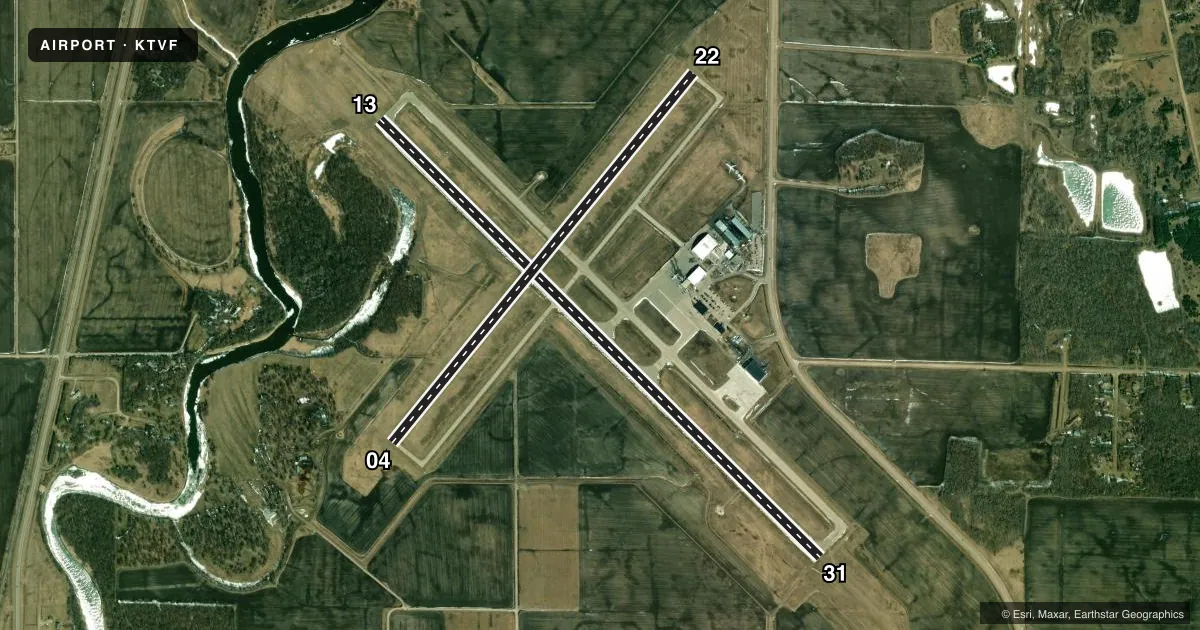
Runways & pattern
Full pagePattern entry · RWY 31
LEFT TRAFFIC| Runway | Heading (°M) | Length | Surface | Traffic |
|---|---|---|---|---|
| 13/31Favored | 133° / 313° | 6,504 ft | ASPH | Standard L |
| 04/22 | 37° / 217° | 4,997 ft | ASPH | Standard L |
Runway end performance
| End | TORA | TODA | ASDA | LDA | VGSI | Approach lights | Obstruction |
|---|---|---|---|---|---|---|---|
| 13 | 6,504' | 6,504' | 6,504' | 6,504' | PAPI 4-box left(3°) | — | — |
| 31 | 6,504' | 6,504' | 6,304' | 6,304' | PAPI 4-box left(3°) | MALSR | — |
| 04 | 4,997' | 4,997' | 4,997' | 4,997' | PAPI 4-box left(3°) | — | — |
| 22 | 4,997' | 4,997' | 4,997' | 4,997' | PAPI 4-box left(3°) | — | — |
Declared distances in feet. TORA = takeoff run available, TODA = takeoff distance, ASDA = accelerate-stop, LDA = landing distance.
Airport sketch
Runways drawn to scale from FAA survey coordinates, rendered over satellite imagery. Not for navigation.
Approaches & charts
ILS · 1
Services on the field
Fuel grades, oxygen, maintenance, ramp storage and lighting — as declared to the FAA by the airport operator.
Fuel & services
- Fuel
- 100LLAA+
- Airframe repair
- Major
- Power plant repair
- Major
- Other services
- AGRI
Ramp & ground
- Transient storage
- Tie-down
- Hangar
- Landing fee
- No fee published
- Customs
- Not available
- Lighting schedule
- SEE RMK
- Beacon schedule
- SS-SR
- Beacon
- White / Green (civil land)(WG)
- Wind indicator
- Lighted
- Segmented circle
- No
Fuel & FBOs
Cheapest 100LL and Jet A on the field and nearby. Always confirm with the FBO before taxi.
Airport notes
Surface conditions, obstructions, local procedures, lighting outages and other notes published with each FAA cycle.
General notes
- BIRDS ON & INVOF ARPT.
- ARPT CONDS NOT MNTD SUN-FRI 2200-0500; FRI 2200-SAT 0600; SAT 1030-1500; SAT 2000-SUN 0600.
- FOR CD IF UNA TO CTC ON FSS FREQ, CTC MINNEAPOLIS ARTCC AT 651-463-5588.
- LDG FEES FOR COML ACFT CALL AMGR 218-681-7680 OPTION 7.
Lighting notes
- ACTVT MALSR RWY 31; REIL RWY 13, 04, & 22; HIRL RWY 13/31; MIRL RWY 04/22 - CTAF. PAPI RWY 13, 31, 04, & 22 OPR CONSLY.
Fuel notes
- 100LLAVBL 24 HRS WITH CREDIT CARD.
Runway surface & condition
- 04/22PCR VALUE: 390/F/D/X/T
- 13/31PCR VALUE: 340/F/D/X/T
- 04/22RWY 04/22 NOT AVBL FOR PART 121/PART 380 OPS WITH SKED PAX CARRYING OPS MORE THAN 9 PAX SEATS AND NON-SKED PAX CARRYING OPS MORE THAN 30 PAX SEATS.
Other notes
- 48 HR PPR FOR UNSKED ACR OPS GTR THAN 30 PAX SEATS CALL AMGR 218-681-7680.
VFR map & nearby airports
VFR sectional. Tap any ICAO chip to open that airport.
Key facts · KTVF
Answer card- ICAO
- KTVF
- Name
- THIEF RIVER FALLS RGNL
- Location
- THIEF RIVER FALLS, MINNESOTA
- Elevation
- 1,118.8 ft MSL
- Traffic pattern altitude
- 2,118.8 ft MSL (1,000 AGL)
- Control tower
- Non-towered (use CTAF)
- Total runways
- 2
- Longest runway
- 13/31 · 6,504 ft
- Published ILS approaches
- 1
- Published frequencies
- 2
- Magnetic variation
- 2°
- Current flight rules
- VFR
- Current wind
- 290° at 6 kt
- Favored runway now
- RWY 31
Thief River Falls Rgnl Airport sits in Thief River Falls, Minnesota. Field elevation is 1,118.8 ft MSL. The airport has 2 asphalt runways. The longest is 13/31 at 6,504 ft. There is no control tower. CTAF and UNICOM are both 122.8.
One ILS is published for runway 31. Pattern altitude is not published. Use 1,000 ft AGL for light piston traffic unless the current Chart Supplement says otherwise. Thief River Aviation is on the field. It carries 100LL and Jet A. 100LL is available 24 hours with credit card. The airport remarks also note bird activity on and near the field. Runway 31 has malfunctioning approach lighting system with runway alignment indicator lights active, so check lighting status before a night arrival.
For runway use, 04/22 is 4,997 ft and 13/31 is 6,504 ft. Runway 04/22 is not available for certain large scheduled passenger operations. Runway 13/31 has no weight limit noted in the remarks. This is a non-towered airport, so plan your self-announce calls carefully. Check the current Chart Supplement for any noise or operating restrictions before you go. The field conditions are not maintained during several overnight and weekend windows, so a preflight weather and surface check matters here.