METAR & TAF 3G2
3G2 does not publish a METAR.
Showing the nearest reporting station: KTVF (THIEF RIVER FALLS RGNL) · 26.2 NM away. Conditions at 3G2 may differ.
METAR · KTVF
Observed 19:56Z
KTVF 271956Z AUTO 35005KT 10SM FEW030 SCT046 29/22 A2982 RMK AO2 SLP092 T02890217
- Wind
- 350° @ 5 kt
- Visibility
- 10 SM
- Temp / Dew
- 29°C / 22°C
- Altimeter
- 29.82 inHg
- Clouds
- SCT
- Density alt
- 3,263 ft
- Ceiling
- Unlimited
- Rules
- VFR
Airport info & contacts
Manager on record, flight service, ARTCC, attendance schedule and pattern altitude — published by the FAA and refreshed every 28 days.
Location
- From city
- 1 NM SW
- VFR sectional
- TWIN CITIES
- ARTCC
- ZMP · MINNEAPOLIS
- NOTAM facility
- PNM (NOTAM-D)
Airport manager
- Name
- ROCKY HAGEN
- Phone
- 218-294-6728
- Address
- 219 W BELTRAMI STREET, P.O. BOX 76, GRYGLA MN 56727
Flight service · Hours
- FSS PNM
- PRINCETON1-800-WX-BRIEF
- Attendance
- Unattended
Frequencies
Tap any row to copy the frequency to your clipboard.
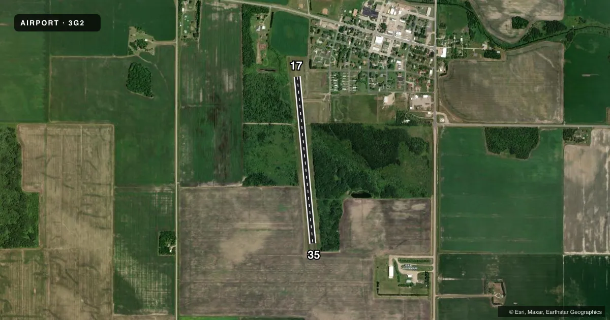
Runways & pattern
Full pagePattern entry · RWY 35
LEFT TRAFFICAirport sketch
Runways drawn to scale from FAA survey coordinates, rendered over satellite imagery. Not for navigation.
Approaches & charts
Services on the field
Fuel grades, oxygen, maintenance, ramp storage and lighting — as declared to the FAA by the airport operator.
Fuel & services
- Fuel
- Not available
- Oxygen (bottled)
- Not available
- Oxygen (bulk)
- Not available
- Airframe repair
- Not available
- Power plant repair
- Not available
Ramp & ground
- Transient storage
- Tie-down
- Lighting schedule
- SS-SR
- Beacon schedule
- SS-SR
- Beacon
- White / Green (civil land)(WG)
- Wind indicator
- Lighted
- Segmented circle
- No
Fuel & FBOs
Cheapest 100LL and Jet A on the field and nearby. Always confirm with the FBO before taxi.
Airport notes
Surface conditions, obstructions, local procedures, lighting outages and other notes published with each FAA cycle.
General notes
- ULTRALIGHT TRAFFIC ON & INVOF ARPT.
- DEER ON & INVOF ARPT.
- AIRPORT NOT PLOWED WINTER MONTHS.
- FOR CD CTC MINNEAPOLIS ARTCC AT 651-463-5588.
- BATHROOM FAC AT THE ADJ PARK.
Approach & departure obstructions
- 17RY 17/35 MARKED WITH YELLOW CONES.
Other notes
- PRVDD CLEAR 20:1 APCH & CLEAR RY SAFETY AREA.
- MANAGERCELL: 218-689-3271
VFR map & nearby airports
VFR sectional. Tap any ICAO chip to open that airport.
Key facts · 3G2
Answer card- ICAO
- 3G2
- Name
- GRYGLA MUNI - MEL WILKENS FLD
- Location
- GRYGLA, MINNESOTA
- Elevation
- 1,177 ft MSL
- Traffic pattern altitude
- 2,177 ft MSL (1,000 AGL)
- Control tower
- Non-towered (use CTAF)
- Total runways
- 1
- Longest runway
- 17/35 · 3,437 ft
- Published ILS approaches
- 0
- Published frequencies
- 1
- Magnetic variation
- 4°
- Current flight rules
- VFR
- Current wind
- 350° at 5 kt
- Favored runway now
- RWY 35
GRYGLA MUNI - MEL WILKENS FLD is in Grygla, Minnesota. Field elevation is 1,177 ft MSL. The airport has one runway. Runway 17/35 is 3,437 ft of turf, so plan for soft-field technique and check the surface before you go. There is no control tower. CTAF is 122.9. No ILS approaches are published here.
Pattern altitude is not published. Use the current FAA Chart Supplement before arrival if you need the local traffic pattern picture. The published remarks also say the runway ends are marked with yellow cones. The field is not plowed in winter. Deer are on and near the airport. Ultralight traffic is also in the area. Keep your scan active in the pattern and on final.
There are no on-field FBOs listed. If you need services, contact the airport operator or the field directly before departure. For clearance delivery, Minneapolis ARTCC is listed in the remarks at 651-463-5588. Bathroom facilities are at the adjacent parking area. This is a small non-towered turf field. Expect self-announce traffic, local users and seasonal surface issues.