METAR & TAF D00
D00 does not publish a METAR.
Showing the nearest reporting station: KFAR (HECTOR INTL) · 26.5 NM away. Conditions at D00 may differ.
METAR · KFAR
Observed 16:10Z
KFAR 271610Z 33012G19KT 9SM OVC015 27/22 A2980 RMK AO2 T02720217 $
- Wind
- 330° @ 12G19 kt
- Visibility
- 9 SM
- Temp / Dew
- 27°C / 22°C
- Altimeter
- 29.80 inHg
- Clouds
- OVC
- Density alt
- 2,772 ft
- Ceiling
- 1,500 ft AGL
- Rules
- MVFR
Airport info & contacts
Manager on record, flight service, ARTCC, attendance schedule and pattern altitude — published by the FAA and refreshed every 28 days.
Location
- From city
- 5 NM SE
- VFR sectional
- TWIN CITIES
- Pattern altitude
- 800 ft AGL · 1,754 ft MSL
- ARTCC
- ZMP · MINNEAPOLIS
- NOTAM facility
- PNM (NOTAM-D)
Airport manager
- Name
- BRUCE VISSER
- Phone
- 218-415-0191
- Address
- PO BOX 9, ADA MN 56510-0009
Flight service · Hours
- FSS PNM
- PRINCETON1-800-WX-BRIEF
- Attendance
- Unattended
Frequencies
Tap any row to copy the frequency to your clipboard.
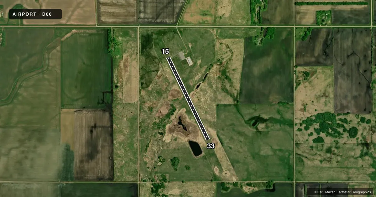
Runways & pattern
Full pagePattern entry · RWY 33
LEFT TRAFFICAirport sketch
Runways drawn to scale from FAA survey coordinates, rendered over satellite imagery. Not for navigation.
Approaches & charts
Services on the field
Fuel grades, oxygen, maintenance, ramp storage and lighting — as declared to the FAA by the airport operator.
Fuel & services
- Fuel
- 100LL
Ramp & ground
- Transient storage
- Tie-down
- Lighting schedule
- SS-SR
- Beacon schedule
- SS-SR
- Beacon
- White / Green (civil land)(WG)
- Wind indicator
- Lighted
- Segmented circle
- No
Fuel & FBOs
Cheapest 100LL and Jet A on the field and nearby. Always confirm with the FBO before taxi.
Airport notes
Surface conditions, obstructions, local procedures, lighting outages and other notes published with each FAA cycle.
General notes
- ULTRALIGHTS ON & INVOF ARPT.
- FOR CD CTC FARGO APCH AT 701-239-5188.
Fuel notes
- 100LLFUEL AVBL H24 VIA CREDIT CARD.
Runway surface & condition
- 15/33SVRL LGTS LEANING.
Other notes
- NON COMPLIANCE FAR 157.
- MANAGERCELL 218-415-0191.
- 15/33CRACKING AND SURFACE EROSION.
VFR map & nearby airports
VFR sectional. Tap any ICAO chip to open that airport.
Key facts · D00
Answer card- ICAO
- D00
- Name
- NORMAN COUNTY ADA/TWIN VALLEY
- Location
- ADA/TWIN VALLEY, MINNESOTA
- Elevation
- 954 ft MSL
- Traffic pattern altitude
- 1,754 ft MSL (800 AGL)
- Control tower
- Non-towered (use CTAF)
- Total runways
- 1
- Longest runway
- 15/33 · 3,103 ft
- Published ILS approaches
- 0
- Published frequencies
- 3
- Magnetic variation
- 5°
- Current flight rules
- MVFR
- Current wind
- 330° at 12 kt
- Favored runway now
- RWY 33
Norman County Ada/Twin Valley Airport sits in Ada/Twin Valley, Minnesota. The field elevation is 954 ft MSL. It has one runway. Runway 15/33 is 3,103 ft of asphalt, so plan your performance with that length in mind. The airport is non-towered. CTAF is 122.9. Fargo Approach handles clearance delivery and approach or departure services on 120.4 and 377.15. No ILS approaches are published here.
Pattern altitude is 800 ft AGL, which is 1,754 ft MSL. That is the number to brief before you join the pattern. Published remarks say runway 15/33 has cracking and surface erosion. Several runway lights are leaning. 100LL is available 24 hours a day by credit card. Ultralight aircraft also operate on and near the airport, so keep your scan active in the pattern and on taxi. There are no on-field FBOs listed, so verify any services with the airport operator or the FBO directly by phone before you go.
For a first-time arrival, the main things to know are the short runway length, the non-towered environment and the published runway condition notes. Check the current FAA Chart Supplement for any noise or curfew restrictions before flying into the field. If you need current operational details, call the airport operator directly.