METAR & TAF D54
D54 does not publish a METAR.
Showing the nearest reporting station: KFAR (HECTOR INTL) · 4.4 NM away. Conditions at D54 may differ.
METAR · KFAR
Observed 22:53Z
KFAR 272253Z 35011KT 10SM FEW060 33/20 A2979 RMK AO2 SLP082 T03280200 $
- Wind
- 350° @ 11 kt
- Visibility
- 10 SM
- Temp / Dew
- 33°C / 20°C
- Altimeter
- 29.79 inHg
- Clouds
- FEW
- Density alt
- 3,432 ft
- Ceiling
- Unlimited
- Rules
- VFR
Airport info & contacts
Manager on record, flight service, ARTCC, attendance schedule and pattern altitude — published by the FAA and refreshed every 28 days.
Location
- From city
- 3 NM NW
- VFR sectional
- TWIN CITIES
- ARTCC
- ZMP · MINNEAPOLIS
- NOTAM facility
- GFK (NOTAM-D)
Airport manager
- Name
- ROBBIE GRANDE
- Phone
- 701-371-2655
- Address
- 1040 19TH AVE NW, WEST FARGO ND 58078
Flight service · Hours
- FSS GFK
- GRAND FORKS1-800-WX-BRIEF
- Attendance
- MON-FRI · 0800-1700
Frequencies
Tap any row to copy the frequency to your clipboard.
Runways & pattern
Full pagePattern entry · RWY 36
LEFT TRAFFICRunway end performance
| End | TORA | TODA | ASDA | LDA | VGSI | Approach lights | Obstruction |
|---|---|---|---|---|---|---|---|
| 18 | — | — | — | — | — | — | 17', road, 365' from thr, 0' R of cntrln, slope 9 |
Declared distances in feet. TORA = takeoff run available, TODA = takeoff distance, ASDA = accelerate-stop, LDA = landing distance.
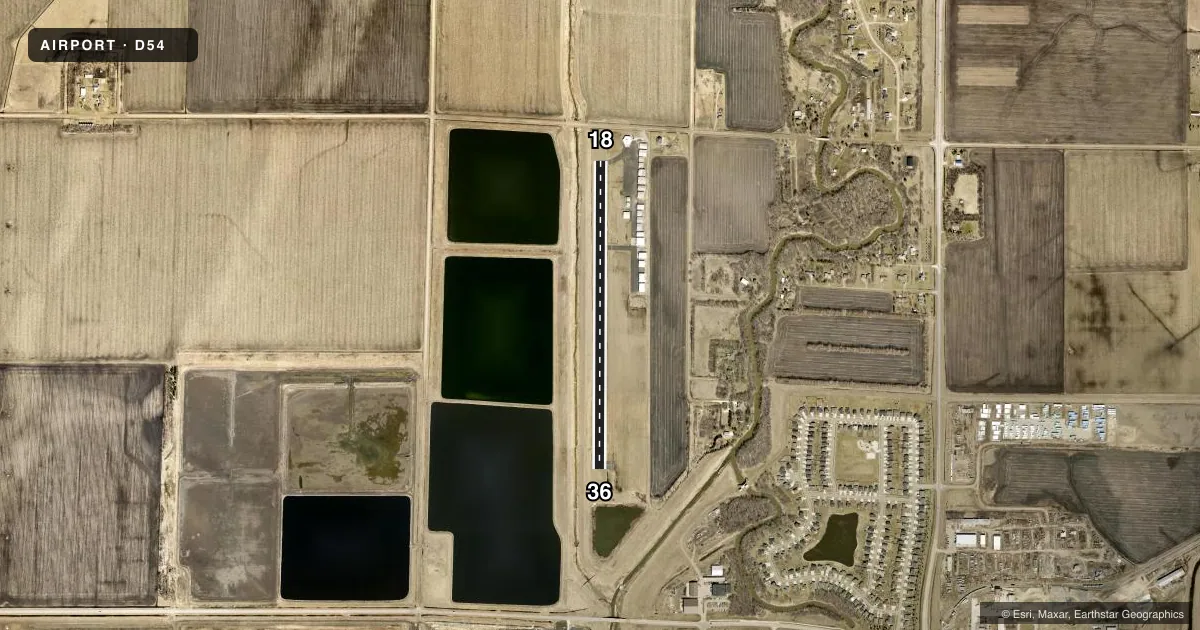
Airport sketch
Runways drawn to scale from FAA survey coordinates, rendered over satellite imagery. Not for navigation.
Approaches & charts
Services on the field
Fuel grades, oxygen, maintenance, ramp storage and lighting — as declared to the FAA by the airport operator.
Fuel & services
- Fuel
- 100LL
- Oxygen (bottled)
- Not available
- Oxygen (bulk)
- Not available
- Airframe repair
- Major
- Power plant repair
- Major
- Other services
- AGRI,INSTR,PAJA,SALES
Ramp & ground
- Transient storage
- Tie-down
- Landing fee
- No fee published
- Lighting schedule
- SEE RMK
- Beacon schedule
- SS-SR
- Beacon
- White / Green (civil land)(WG)
- Wind indicator
- Lighted
- Segmented circle
- Yes
Fuel & FBOs
Cheapest 100LL and Jet A on the field and nearby. Always confirm with the FBO before taxi.
Airport notes
Surface conditions, obstructions, local procedures, lighting outages and other notes published with each FAA cycle.
General notes
- CFM WINTER CONDS AFT MAJOR STORM - CALL AMGR.
- DEER & BIRDS ON & INVOF ARPT.
- PAJA ON & INVOF ARPT.
- FOR CD CTC FARGO APCH AT 701-239-5188.
- TFC PATTERN 800 FT AGL.
Lighting notes
- ACTVT LIRL RY 18/36 - CTAF.
Fuel notes
- 100LLSELF SVC AVBL WITH CREDIT CARD .
Approach & departure obstructions
- 18MRKGS FADED.
- 36MRKGS FADED.
Other notes
- OWNERBRIAN CHRISTL CHRMN ARPT AUTH.
VFR map & nearby airports
VFR sectional. Tap any ICAO chip to open that airport.
Key facts · D54
Answer card- ICAO
- D54
- Name
- WEST FARGO MUNI
- Location
- FARGO, NORTH DAKOTA
- Elevation
- 896 ft MSL
- Traffic pattern altitude
- 1,896 ft MSL (1,000 AGL)
- Control tower
- Non-towered (use CTAF)
- Total runways
- 1
- Longest runway
- 18/36 · 3,300 ft
- Published ILS approaches
- 0
- Published frequencies
- 3
- Magnetic variation
- 6°
- Current flight rules
- VFR
- Current wind
- 350° at 11 kt
- Favored runway now
- RWY 36
West Fargo Muni sits in Fargo, North Dakota. Field elevation is 896 ft MSL. The airport has one runway, 18/36, which is 3,300 ft of asphalt. There is no control tower. Pattern altitude is 800 ft AGL, which puts the light-piston pattern at 1,696 ft MSL.
No ILS approaches are published here. CTAF is 122.7. Fargo Approach handles clearance delivery. Published remarks also note low intensity runway lights on 18/36 that are activated by CTAF. Runway markings on both ends are faded. Plan for a careful look on rollout and lineup.
Delta 54 Aviation is on the field. It carries 100LL. Self-service 100LL is available with credit card. The airport remarks also call out deer and birds in the area. Paja is also noted in the vicinity. If you are arriving after a major winter storm, confirm conditions with the airport manager before you go. For a first-time stop, the big items are the short single runway, the non-towered pattern and the need to verify winter surface conditions before departure.