METAR & TAF 3H4
3H4 does not publish a METAR.
Showing the nearest reporting station: KFAR (HECTOR INTL) · 28.2 NM away. Conditions at 3H4 may differ.
METAR · KFAR
Observed 07:53Z
KFAR 270753Z 28009KT 10SM CLR 22/14 A2972 RMK AO2 SLP056 T02170139
- Wind
- 280° @ 9 kt
- Visibility
- 10 SM
- Temp / Dew
- 22°C / 14°C
- Altimeter
- 29.72 inHg
- Clouds
- CLR
- Density alt
- 2,212 ft
- Ceiling
- Unlimited
- Rules
- VFR
Airport info & contacts
Manager on record, flight service, ARTCC, attendance schedule and pattern altitude — published by the FAA and refreshed every 28 days.
Location
- From city
- 3 NM S
- VFR sectional
- TWIN CITIES
- ARTCC
- ZMP · MINNEAPOLIS
- NOTAM facility
- GFK (NOTAM-D)
Airport manager
- Name
- DEVON COTE
- Phone
- 701-436-6167
- Address
- BOX 242, HILLSBORO ND 58045
Flight service · Hours
- FSS GFK
- GRAND FORKS1-800-WX-BRIEF
- Attendance
- MON-FRI · 0800-1700
Frequencies
Tap any row to copy the frequency to your clipboard.
Runways & pattern
Full pagePattern entry · RWY 34
LEFT TRAFFICRunway end performance
| End | TORA | TODA | ASDA | LDA | VGSI | Approach lights | Obstruction |
|---|---|---|---|---|---|---|---|
| 16 | — | — | — | — | PAPI 2-box left(3°) | — | — |
| 34 | — | — | — | — | PAPI 2-box left(3°) | — | — |
Declared distances in feet. TORA = takeoff run available, TODA = takeoff distance, ASDA = accelerate-stop, LDA = landing distance.
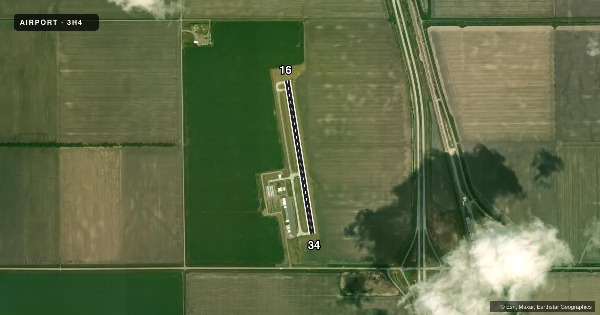
Airport sketch
Runways drawn to scale from FAA survey coordinates, rendered over satellite imagery. Not for navigation.
Approaches & charts
Services on the field
Fuel grades, oxygen, maintenance, ramp storage and lighting — as declared to the FAA by the airport operator.
Fuel & services
- Fuel
- 100LL
- Airframe repair
- Major
- Power plant repair
- Major
- Other services
- AGRI,AVNCS,INSTR,RNTL,SALES
Ramp & ground
- Transient storage
- Tie-down
- Hangar
- Landing fee
- No fee published
- Customs
- Not available
- Lighting schedule
- SEE RMK
- Beacon schedule
- SS-SR
- Beacon
- White / Green (civil land)(WG)
- Wind indicator
- Yes
- Segmented circle
- No
Fuel & FBOs
Cheapest 100LL and Jet A on the field and nearby. Always confirm with the FBO before taxi.
Airport notes
Surface conditions, obstructions, local procedures, lighting outages and other notes published with each FAA cycle.
General notes
- FOR SNOW REMOVAL OR WINTER CONDS CALL ARPT 701-400-1113 OR 701-436-6167.
- AERIAL SPRAYING OPNS MAY-AUG INVOF ARPT.
- FOR CD CTC FARGO APCH AT 701-239-5188.
- MIGRATORY WATERFOWL ON & INVOF ARPT.
- ARPT HAS NMRS FLT TRNG OPS DAILY FM GRAND FORKS INTL ARPT.
Lighting notes
- ACTVT PAPI RWY 16 & 34; MIRL RWY 16/34 - CTAF.
Fuel notes
- 100LL24 HOUR SELF SERVICE CREDIT CARD FUEL AVBL.
Other notes
- AIRSPACE CASE 74-RM-182-NRA.
- 1AFT HRS ON CALL 701-400-1113
- AGRIFOR AGRI SVC CTC 218-415-0205.
- SALESACFT PAINT & AVIONICS SVCS AVBL ON ARPT CALL 701-400-1113.
VFR map & nearby airports
VFR sectional. Tap any ICAO chip to open that airport.
Key facts · 3H4
Answer card- ICAO
- 3H4
- Name
- HILLSBORO MUNI
- Location
- HILLSBORO, NORTH DAKOTA
- Elevation
- 906.1 ft MSL
- Traffic pattern altitude
- 1,906.1 ft MSL (1,000 AGL)
- Control tower
- Non-towered (use CTAF)
- Total runways
- 1
- Longest runway
- 16/34 · 3,301 ft
- Published ILS approaches
- 0
- Published frequencies
- 3
- Magnetic variation
- 5°
- Current flight rules
- VFR
- Current wind
- 280° at 9 kt
- Favored runway now
- RWY 34
Hillsboro Muni (3H4) sits in Hillsboro, North Dakota. Field elevation is 906.1 ft MSL. The airport has one runway. Runway 16/34 is 3,301 ft long with concrete pavement. There is no control tower. CTAF is 122.9. Fargo Approach handles clearance delivery and approach services.
No ILS approaches are published here. Pattern altitude is not published, so use the standard 1,000 ft AGL for light piston aircraft unless the current Chart Supplement says otherwise. The airport has PAPI on runways 16 and 34. Medium intensity runway lights are also available on both ends. Use CTAF for lighting activation.
On-Site Aviation is on the field. It carries 100LL. Twenty-four hour self-serve credit card fuel is available for 100LL. After-hours service is available by phone. The airport also has aircraft painting and avionics services on site.
A first-time pilot should plan for a non-towered airport with regular training traffic. The remarks also note aerial spraying in the area from May through August. Migratory waterfowl are reported on and near the airport. In winter, call ahead for snow removal or field conditions before departure. Check the current FAA Chart Supplement for any published airspace or operational notes tied to the listed airspace case.