METAR & TAF S32
Current METAR
Observed 01:15Z
KS32 280115Z AUTO 00000KT 10SM 27/21 A2986 RMK AO2 TSNO
- Wind
- 000° @ 0 kt
- Visibility
- 10 SM
- Temp / Dew
- 27°C / 21°C
- Altimeter
- 29.86 inHg
- Clouds
- Clear
- Density alt
- 3,281 ft
- Ceiling
- Unlimited
- Rules
- VFR
Airport info & contacts
Manager on record, flight service, ARTCC, attendance schedule and pattern altitude — published by the FAA and refreshed every 28 days.
Location
- From city
- 2 NM SE
- VFR sectional
- TWIN CITIES
- ARTCC
- ZMP · MINNEAPOLIS
- NOTAM facility
- GFK (NOTAM-D)
Airport manager
- Name
- LORAN ANDERSON
- Phone
- 701-309-1201
- Address
- 301 13TH ST SE, COOPERSTOWN ND 58425
Flight service · Hours
- FSS GFK
- GRAND FORKS1-800-WX-BRIEF
- Attendance
- OCT-APR · ON CALL
- MAY-SEP · MON-FRI · 0800-1700
Frequencies
Tap any row to copy the frequency to your clipboard.
Runways & pattern
Full pagePattern entry · RWY 13
LEFT TRAFFICRunway end performance
| End | TORA | TODA | ASDA | LDA | VGSI | Approach lights | Obstruction |
|---|---|---|---|---|---|---|---|
| 13 | — | — | — | — | PAPI 2-box left(3°) | — | — |
| 31 | — | — | — | — | PAPI 2-box left(3°) | — | — |
Declared distances in feet. TORA = takeoff run available, TODA = takeoff distance, ASDA = accelerate-stop, LDA = landing distance.
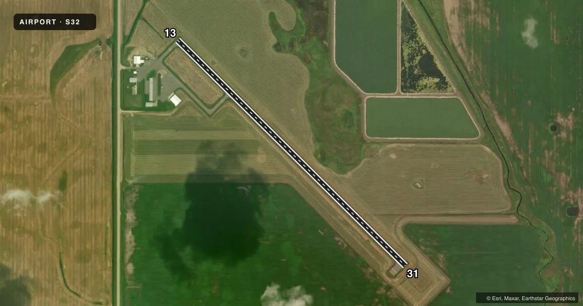
Airport sketch
Runways drawn to scale from FAA survey coordinates, rendered over satellite imagery. Not for navigation.
Approaches & charts
Services on the field
Fuel grades, oxygen, maintenance, ramp storage and lighting — as declared to the FAA by the airport operator.
Fuel & services
- Fuel
- 100LL
- Oxygen (bottled)
- Not available
- Oxygen (bulk)
- Not available
- Airframe repair
- Not available
- Power plant repair
- Not available
- Other services
- AGRI,INSTR
Ramp & ground
- Transient storage
- Tie-down
- Hangar
- Landing fee
- No fee published
- Lighting schedule
- SEE RMK
- Wind indicator
- Lighted
- Segmented circle
- Yes
Fuel & FBOs
Cheapest 100LL and Jet A on the field and nearby. Always confirm with the FBO before taxi.
Airport notes
Surface conditions, obstructions, local procedures, lighting outages and other notes published with each FAA cycle.
General notes
- CONFIRM WINTER COND & SNOW REMOVAL WITH AMGR.
- HELICOPTER LNDG AREA LCTD EAST APRON EDGE; SNOW REMOVAL IREG.
- BIRDS & DEER INVOF ARPT.
- FOR CD CTC MINNEAPOLIS ARTCC AT 651-463-5588.
Lighting notes
- MIRL ON RY 13/31 PRESET ON LOW INTST; TO INCR INTST & ACTIVATE RYS 13, 31 PAPI - CTAF.
Fuel notes
- 100LLSELF SVC FUEL AVBL H24.
Other notes
- OWNERLORAN ANDERSON - CHRMN ARPT AUTH.
- MANAGERADDNL PHONE - SHERIFF 701-797-2202.
- AGRIFOR AGRI SVC CRC AMGR APR-OCT.
VFR map & nearby airports
VFR sectional. Tap any ICAO chip to open that airport.
Key facts · S32
Answer card- ICAO
- S32
- Name
- COOPERSTOWN MUNI
- Location
- COOPERSTOWN, NORTH DAKOTA
- Elevation
- 1,424.4 ft MSL
- Traffic pattern altitude
- 2,424.4 ft MSL (1,000 AGL)
- Control tower
- Non-towered (use CTAF)
- Total runways
- 1
- Longest runway
- 13/31 · 3,500 ft
- Published ILS approaches
- 0
- Published frequencies
- 1
- Magnetic variation
- 6°
- Current flight rules
- VFR
- Current wind
- 000° at 0 kt
- Favored runway now
- –
Cooperstown Muni is in Cooperstown, North Dakota. The field elevation is 1,424.4 ft MSL. It has one runway, 13/31, which is 3,500 ft long and asphalt. There is no control tower. CTAF is 122.9. No ILS approaches are published here.
Pattern altitude is not published. Use the standard 1,000 ft AGL unless local procedures or current airport guidance say otherwise. The airport sits in open country, so expect normal prairie wind effects. Birds and deer are reported in the area. Snow removal is irregular, so winter conditions deserve a close check before departure or arrival.
Cooperstown Municipal Airport is the on-field FBO. It carries 100LL. Self-service 100LL is available 24 hours a day. For agricultural service, contact the airport manager from April to October. Runway lights on 13/31 are preset to low intensity. Use the CTAF to increase intensity and activate the PAPI for runways 13 and 31. A helicopter landing area is located at the east apron edge. For clearance delivery, contact Minneapolis ARTCC. If you are planning a first visit, verify winter surface conditions and any operational details with the airport manager before you go.