METAR & TAF D56
D56 does not publish a METAR.
Showing the nearest reporting station: KGFK (GRAND FORKS INTL) · 28.9 NM away. Conditions at D56 may differ.
METAR · KGFK
Observed 17:53Z
KGFK 271753Z 32006KT 9SM BKN030 BKN036 29/22 A2979 RMK AO2 SLP082 FU ALOFT T02940217 10306 20217 53002 $
- Wind
- 320° @ 6 kt
- Visibility
- 9 SM
- Temp / Dew
- 29°C / 22°C
- Altimeter
- 29.79 inHg
- Clouds
- BKN
- Density alt
- 3,053 ft
- Ceiling
- 3,000 ft AGL
- Rules
- MVFR
Airport info & contacts
Manager on record, flight service, ARTCC, attendance schedule and pattern altitude — published by the FAA and refreshed every 28 days.
Location
- From city
- 1 NM S
- VFR sectional
- TWIN CITIES
- ARTCC
- ZMP · MINNEAPOLIS
- NOTAM facility
- GFK (NOTAM-D)
Airport manager
- Name
- LANCE FUGLEBERG
- Phone
- 701-361-0330
- Address
- PO BOX 219, MAYVILLE ND 58257
Flight service · Hours
- FSS GFK
- GRAND FORKS1-800-WX-BRIEF
- Attendance
- ON CALL
Frequencies
Tap any row to copy the frequency to your clipboard.
Runways & pattern
Full pagePattern entry · RWY 36
LEFT TRAFFICRunway end performance
| End | TORA | TODA | ASDA | LDA | VGSI | Approach lights | Obstruction |
|---|---|---|---|---|---|---|---|
| 18 | — | — | — | — | — | — | 15', road, 775' from thr, 0' R of cntrln, slope 20 |
Declared distances in feet. TORA = takeoff run available, TODA = takeoff distance, ASDA = accelerate-stop, LDA = landing distance.
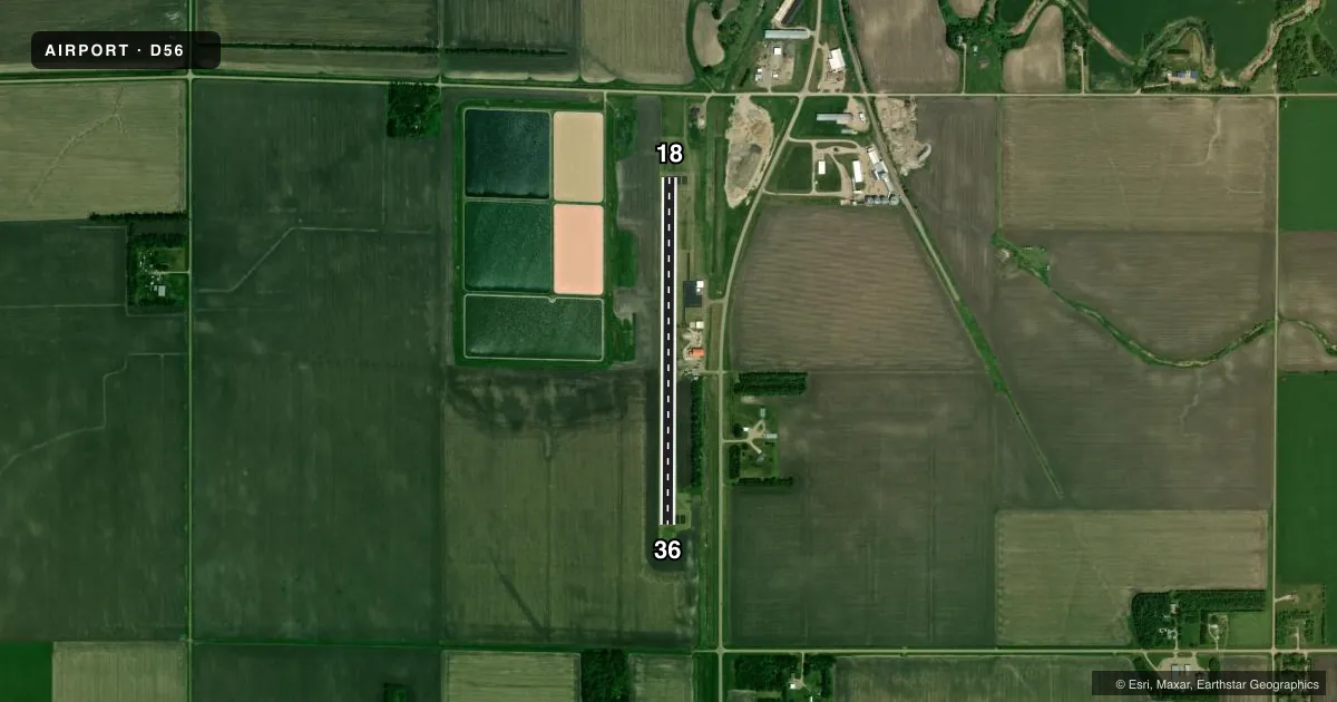
Airport sketch
Runways drawn to scale from FAA survey coordinates, rendered over satellite imagery. Not for navigation.
Approaches & charts
Services on the field
Fuel grades, oxygen, maintenance, ramp storage and lighting — as declared to the FAA by the airport operator.
Fuel & services
- Fuel
- Not available
- Other services
- AGRI
Ramp & ground
- Transient storage
- Tie-down
- Landing fee
- No fee published
- Customs
- Not available
- Lighting schedule
- SEE RMK
- Beacon schedule
- SS-SR
- Beacon
- White / Green (civil land)(WG)
- Wind indicator
- Yes
- Segmented circle
- No
Fuel & FBOs
Cheapest 100LL and Jet A on the field and nearby. Always confirm with the FBO before taxi.
Airport notes
Surface conditions, obstructions, local procedures, lighting outages and other notes published with each FAA cycle.
General notes
- RWY 36 2063 FT AGL TWR MKD & LGTD 7.5 NM S OF EXTDD CNTRLN; ADDL 2060 FT AGL TWR MKD & LGTD 11.5 NM S OF EXTDD CNTRLN.
- ARPT HAS NUMEROUS FLIGHT TRAINING OPNS DAILY FROM GRAND FORKS INTL ARPT.
- CFM WINTER CONDS & SN REMOVAL BFR USE CALL 701-786-4240; 701-238-0790.
- MIGRATORY WATERFOWL ON & INVOF ARPT.
- FOR CD CTC MINNEAPOLIS ARTCC AT 651-463-5588.
Lighting notes
- ACTVT MIRL RWY 18/36 - CTAF.
VFR map & nearby airports
VFR sectional. Tap any ICAO chip to open that airport.
Key facts · D56
Answer card- ICAO
- D56
- Name
- MAYVILLE MUNI
- Location
- MAYVILLE, NORTH DAKOTA
- Elevation
- 977 ft MSL
- Traffic pattern altitude
- 1,977 ft MSL (1,000 AGL)
- Control tower
- Non-towered (use CTAF)
- Total runways
- 1
- Longest runway
- 18/36 · 3,300 ft
- Published ILS approaches
- 0
- Published frequencies
- 2
- Magnetic variation
- 6°
- Current flight rules
- MVFR
- Current wind
- 320° at 6 kt
- Favored runway now
- RWY 36
Mayville Muni sits in Mayville, North Dakota. The field elevation is 977 ft MSL. It has one runway, 18/36, which is 3,300 ft of asphalt. There is no control tower. CTAF and UNICOM are both 122.8.
No ILS approaches are published here. The pattern altitude is not published, so use the standard 1,000 ft AGL for light piston operations unless the current Chart Supplement says otherwise. Runway 18/36 has medium intensity lighting that is activated on CTAF. That helps for night work, but you still want to verify the lighting plan before you go.
There are no on-field FBOs listed in the facts. Contact the airport operator directly before arrival, or call the field on CTAF or UNICOM for current service status. The published remarks also call out winter conditions and snow removal. Confirm both before use. The area has migratory waterfowl near the airport. There are also numerous flight training operations from Grand Forks International Airport. Runway 36 has tall marked and lighted towers south of the extended centerline. Give yourself room on departure and arrival. For clearances, Minneapolis ARTCC is the published contact.