METAR & TAF 2L1
2L1 does not publish a METAR.
Showing the nearest reporting station: KGFK (GRAND FORKS INTL) · 18.9 NM away. Conditions at 2L1 may differ.
METAR · KGFK
Observed 04:53Z
KGFK 140453Z AUTO 29005KT 10SM BKN055 09/08 A3004 RMK AO2 SLP178 T00940078
- Wind
- 290° @ 5 kt
- Visibility
- 10 SM
- Temp / Dew
- 9°C / 8°C
- Altimeter
- 30.04 inHg
- Clouds
- BKN
- Density alt
- 532 ft
- Ceiling
- 5,500 ft AGL
- Rules
- VFR
Airport info & contacts
Manager on record, flight service, ARTCC, attendance schedule and pattern altitude — published by the FAA and refreshed every 28 days.
Location
- From city
- 1 NM W
- VFR sectional
- TWIN CITIES
- ARTCC
- ZMP · MINNEAPOLIS
- NOTAM facility
- GFK (NOTAM-D)
Airport manager
- Name
- JESSE MORTEN
- Phone
- 218-779-4244
- Address
- 1546 37TH ST NE, LARIMORE ND 58251
Flight service · Hours
- FSS GFK
- GRAND FORKS1-800-WX-BRIEF
- Attendance
- MON-SAT · ON CALL
Frequencies
Tap any row to copy the frequency to your clipboard.
Runways & pattern
Full pagePattern entry · RWY 30
LEFT TRAFFICRunway end performance
| End | TORA | TODA | ASDA | LDA | VGSI | Approach lights | Obstruction |
|---|---|---|---|---|---|---|---|
| 30 | — | — | — | — | — | — | 17', road, 200' from thr, 40' R of cntrln, slope 0 |
Declared distances in feet. TORA = takeoff run available, TODA = takeoff distance, ASDA = accelerate-stop, LDA = landing distance.
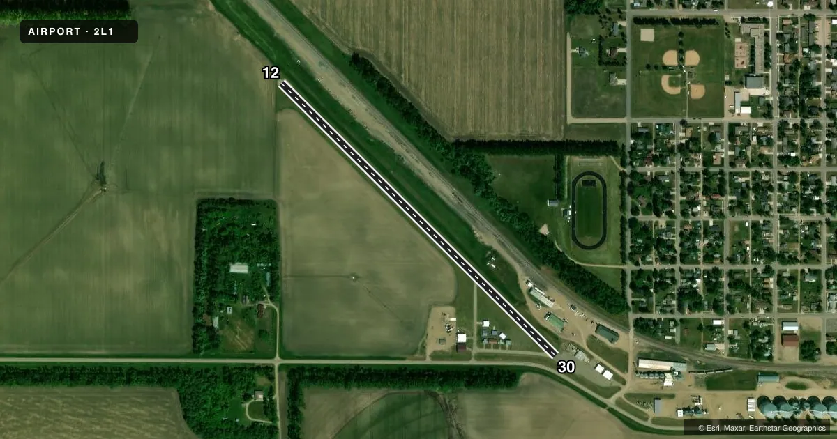
Airport sketch
Runways drawn to scale from FAA survey coordinates, rendered over satellite imagery. Not for navigation.
Approaches & charts
Services on the field
Fuel grades, oxygen, maintenance, ramp storage and lighting — as declared to the FAA by the airport operator.
Fuel & services
- Fuel
- Not available
- Oxygen (bottled)
- Not available
- Oxygen (bulk)
- Not available
- Airframe repair
- Not available
- Power plant repair
- Not available
- Other services
- AGRI,INSTR,SALES
Ramp & ground
- Transient storage
- Tie-down
- Landing fee
- No fee published
- Customs
- Not available
- Lighting schedule
- SS-SR
- Wind indicator
- Yes
- Segmented circle
- No
Fuel & FBOs
Cheapest 100LL and Jet A on the field and nearby. Always confirm with the FBO before taxi.
Airport notes
Surface conditions, obstructions, local procedures, lighting outages and other notes published with each FAA cycle.
General notes
- SNOW REMOVAL IREG OCT THRU MAY. FOR CONDITIONS REPORT CONTACT AMGR AT 701-343-2065 OR CELL 218-779-4244
- FOR CD CTC MINNEAPOLIS ARTCC AT 651-463-5588.
Approach & departure obstructions
- 3015 FT PKD ACFT 150 FT FM THR 50 FT R ON APRON AREA; 17 FT ROAD AT THR 100 FT L; 36 FT WINDSOCK/BLDG 170 FT FM THR & 120 R OF EXTDD CNTRLN.
- 3025 FT POLE 650 FT FM THR & 140 FT R OF EXTDD CNTRLN; APCH RATIO 18:1.
Other notes
- MANAGERADDL CTC JOHN MORTEN 701-343-6211.
- MANAGERAMGR'S CELL PHONE AT 218-779-4244.
- OWNERTODD YAHNE - CHAIRMAN: 218-779-1171
VFR map & nearby airports
VFR sectional. Tap any ICAO chip to open that airport.
Key facts · 2L1
Answer card- ICAO
- 2L1
- Name
- LARIMORE MUNI
- Location
- LARIMORE, NORTH DAKOTA
- Elevation
- 1,130 ft MSL
- Traffic pattern altitude
- 2,130 ft MSL (1,000 AGL)
- Control tower
- Non-towered (use CTAF)
- Total runways
- 1
- Longest runway
- 12/30 · 2,914 ft
- Published ILS approaches
- 0
- Published frequencies
- 1
- Magnetic variation
- 7°
- Current flight rules
- VFR
- Current wind
- 290° at 5 kt
- Favored runway now
- RWY 30
Larimore Muni (2L1) sits in Larimore, North Dakota. The field elevation is 1,130 ft MSL. It has one runway. Runway 12/30 is 2,914 ft long with asphalt pavement. There is no control tower. CTAF is 122.9.
No ILS approaches are published here. Pattern altitude is not published, so use the standard 1,000 ft AGL for light piston traffic unless local procedure says otherwise. With a single short runway and no tower, plan your arrival early and make your radio calls clearly on CTAF.
Published remarks show a few things worth having in mind before you go. There is a 25-foot pole near the runway 30 approach path. There is also a parked aircraft and a road near that end, plus a windsock and building close to the extended centerline. Snow removal is irregular from October through May, so runway condition can change fast in winter. For current conditions, contact the airport manager or the airport office directly before departure. No on-field FBOs are listed, so verify fuel and services with the airport operator before you launch.