METAR & TAF 8M6
8M6 does not publish a METAR.
Showing the nearest reporting station: KDVL (DEVILS LAKE RGNL) · 35.8 NM away. Conditions at 8M6 may differ.
METAR · KDVL
Observed 02:56Z
KDVL 140256Z AUTO 01003KT 10SM CLR 13/07 A3006 RMK AO2 SLP188 T01280072 53017
- Wind
- 010° @ 3 kt
- Visibility
- 10 SM
- Temp / Dew
- 13°C / 7°C
- Altimeter
- 30.06 inHg
- Clouds
- CLR
- Density alt
- 1,413 ft
- Ceiling
- Unlimited
- Rules
- VFR
Airport info & contacts
Manager on record, flight service, ARTCC, attendance schedule and pattern altitude — published by the FAA and refreshed every 28 days.
Location
- From city
- 1 NM NW
- VFR sectional
- TWIN CITIES
- ARTCC
- ZMP · MINNEAPOLIS
- NOTAM facility
- GFK (NOTAM-D)
Airport manager
- Name
- NEIL REITEN
- Phone
- (701) 739-1345
- Address
- PO BOX 275, MCVILLE ND 58254
Flight service · Hours
- FSS GFK
- GRAND FORKS1-800-WX-BRIEF
- Attendance
- Unattended
Frequencies
Tap any row to copy the frequency to your clipboard.
Runways & pattern
Full pagePattern entry · RWY 36
LEFT TRAFFIC| Runway | Heading (°M) | Length | Surface | Traffic |
|---|---|---|---|---|
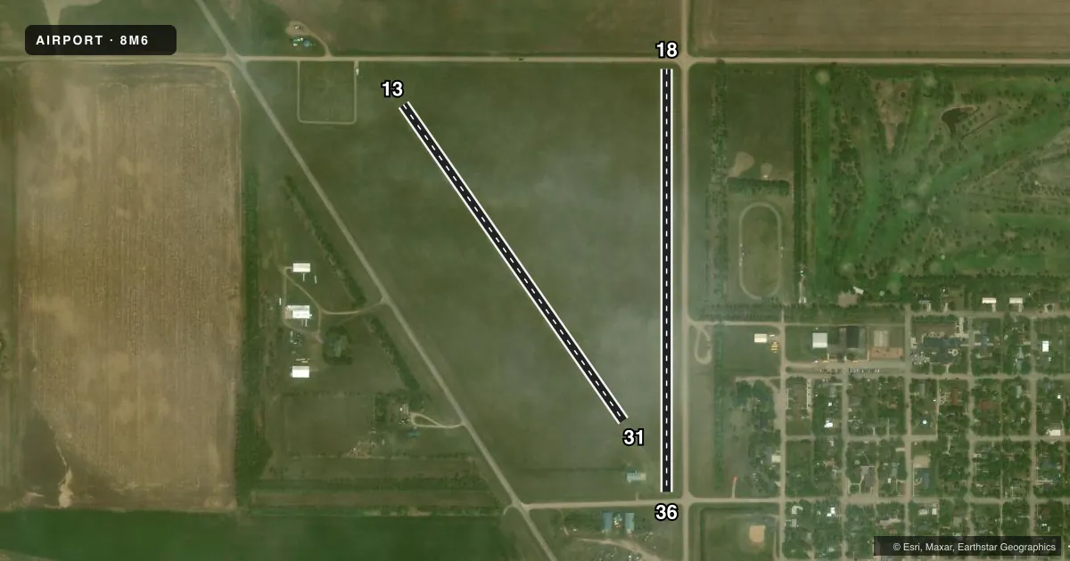
| 18/36Favored | 173° / 353° | 2,500 ft | TURF | Standard L |
| 13/31 | 138° / 318° | 2,277 ft | TURF | Standard L |
Runway end performance
| End | TORA | TODA | ASDA | LDA | VGSI | Approach lights | Obstruction |
|---|---|---|---|---|---|---|---|
| 18 | — | — | — | — | — | — | 18', road, 0' from thr, 95' R of cntrln, slope 0 |
| 36 | — | — | — | — | — | — | 18', road, 0' from thr, 105' R of cntrln, slope 0 |
| 13 | — | — | — | — | — | — | 19', road, 210' from thr, 150' R of cntrln, slope 11 |
| 31 | — | — | — | — | — | — | 18', bldg, 275' from thr, 125' R of cntrln, slope 15 |
Declared distances in feet. TORA = takeoff run available, TODA = takeoff distance, ASDA = accelerate-stop, LDA = landing distance.
Airport sketch
Runways drawn to scale from FAA survey coordinates, rendered over satellite imagery. Not for navigation.
Approaches & charts
Services on the field
Fuel grades, oxygen, maintenance, ramp storage and lighting — as declared to the FAA by the airport operator.
Fuel & services
- Fuel
- Not available
- Oxygen (bottled)
- Not available
- Oxygen (bulk)
- Not available
- Airframe repair
- Not available
- Power plant repair
- Not available
- Other services
- AGRI
Ramp & ground
- Transient storage
- Tie-down
- Landing fee
- No fee published
- Customs
- Not available
- Lighting schedule
- SEE RMK
- Wind indicator
- Yes
- Segmented circle
- No
Fuel & FBOs
Cheapest 100LL and Jet A on the field and nearby. Always confirm with the FBO before taxi.
Airport notes
Surface conditions, obstructions, local procedures, lighting outages and other notes published with each FAA cycle.
General notes
- CALL AMGR TO CONFIRM SNOW REMOVAL 701-270-2820.
- FOR CD CTC MINNEAPOLIS ARTCC AT 651-463-5588.
- RWY 36 HAS MULTIPLE 110 FT BLDGS 1400 FT FM THLD; L AND R OF CNTRLN; APCH RATIO 12:1.
- RWY 36 HAS 40 FT TREES 175 FT FM THLD; 110 FT L OF CNTRLN; APCH RATIO 4:1.
- RWY 31 HAS 40 FT TREES 720 FT FM THLD; L AND R OF CNTRLN; APCH RATIO 18:1.
Lighting notes
- ACTIVATE LIRL RY 13/31 - CTAF.
Runway surface & condition
- 13/31200 FT TURF STWY ON NW END & 500 FT TURF STWY ON SE END.
Approach & departure obstructions
- 18HAS ROAD 40 FT FM THLD; L AND R OF CNTRLN; APCH RATIO 2:1.
- 36HAS ROAD 48 FT FM THLD; L AND R OF CNTRLN; APCH RATIO 2:1.
Other notes
- PRVDD AN OBSTN-FREE PRIM SFC 125' EACH SIDE OF RWY CNTRLN IS ESTABD. IF THERE ARE OBSTNS IN THE APCH AREAS THAT CANNOT BE LOWERED OR REMOVED; THE RWY THRS ARE LCTD SO AS TO PRVD 20:1 CLEARANCE OVER ALL OBSTNS.
- OWNERCHANDA ARNESON - CITY AUDITOR 701-322-4343.
- 13/31TURF SFC ROLLING.
VFR map & nearby airports
VFR sectional. Tap any ICAO chip to open that airport.
Key facts · 8M6
Answer card- ICAO
- 8M6
- Name
- MC VILLE MUNI
- Location
- MC VILLE, NORTH DAKOTA
- Elevation
- 1,473 ft MSL
- Traffic pattern altitude
- 2,473 ft MSL (1,000 AGL)
- Control tower
- Non-towered (use CTAF)
- Total runways
- 2
- Longest runway
- 18/36 · 2,500 ft
- Published ILS approaches
- 0
- Published frequencies
- 1
- Magnetic variation
- 7°
- Current flight rules
- VFR
- Current wind
- 010° at 3 kt
- Favored runway now
- RWY 36
MC Ville Muni sits in Mc Ville, North Dakota. The field elevation is 1,473 ft MSL. It has two turf runways. The longest is 2,500 ft on runway 18/36. This is an untowered airport. Use CTAF 122.9 for traffic calls and watch the pattern closely.
No ILS approaches are published here. The pattern altitude is not published, so use the standard 1,000 ft AGL pattern for light piston traffic unless the current Chart Supplement says otherwise. Runway 13/31 has a rolling turf surface. It also has turf stopways on both ends. Runway 13/31 lights can be activated on CTAF.
There are no on-field FBOs listed. Plan on self-sufficiency for arrival and departure. Published remarks note trees near the approach to runway 31. They also note roads close to the thresholds on runways 18 and 36. Buildings sit near the runway 36 approach path. That makes a careful wind check and a good stabilized approach important. Snow removal should be confirmed with the airport manager before winter operations. For clearance delivery, Minneapolis ARTCC is listed in the remarks.