METAR & TAF Y37
Y37 does not publish a METAR.
Showing the nearest reporting station: KGAF (HUTSON FLD) · 16.3 NM away. Conditions at Y37 may differ.
METAR · KGAF
Observed 18:35Z
KGAF 271835Z AUTO 35008KT 9SM FEW028 30/22 A2982 RMK AO2 PWINO
- Wind
- 350° @ 8 kt
- Visibility
- 9 SM
- Temp / Dew
- 30°C / 22°C
- Altimeter
- 29.82 inHg
- Clouds
- FEW
- Density alt
- 3,293 ft
- Ceiling
- Unlimited
- Rules
- VFR
Airport info & contacts
Manager on record, flight service, ARTCC, attendance schedule and pattern altitude — published by the FAA and refreshed every 28 days.
Location
- From city
- 1 NM W
- VFR sectional
- TWIN CITIES
- ARTCC
- ZMP · MINNEAPOLIS
- NOTAM facility
- GFK (NOTAM-D)
Airport manager
- Name
- JAYSE WHARAM
- Phone
- 701-331-0818
- Address
- P.O. BOX 611, PARK RIVER ND 58270
Flight service · Hours
- FSS GFK
- GRAND FORKS1-800-WX-BRIEF
- Attendance
- ON CALL
Frequencies
Tap any row to copy the frequency to your clipboard.
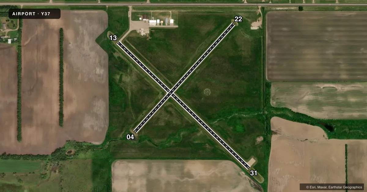
Runways & pattern
Full pagePattern entry · RWY 31
LEFT TRAFFIC| Runway | Heading (°M) | Length | Surface | Traffic |
|---|---|---|---|---|
| 13/31Favored | 131° / 311° | 3,100 ft | ASPH | Standard L |
| 04/22 | 39° / 219° | 2,499 ft | TURF | Standard L |
Runway end performance
| End | TORA | TODA | ASDA | LDA | VGSI | Approach lights | Obstruction |
|---|---|---|---|---|---|---|---|
| 13 | — | — | — | — | PAPI 2-box left(3°) | — | 103', trees, 2100' from thr, 100' R of cntrln, slope 18 |
| 31 | — | — | — | — | PAPI 2-box left(3°) | — | — |
Declared distances in feet. TORA = takeoff run available, TODA = takeoff distance, ASDA = accelerate-stop, LDA = landing distance.
Airport sketch
Runways drawn to scale from FAA survey coordinates, rendered over satellite imagery. Not for navigation.
Approaches & charts
Services on the field
Fuel grades, oxygen, maintenance, ramp storage and lighting — as declared to the FAA by the airport operator.
Fuel & services
- Fuel
- 100LLA
- Oxygen (bottled)
- Not available
- Oxygen (bulk)
- Not available
- Airframe repair
- Not available
- Power plant repair
- Not available
- Other services
- AGRI,INSTR
Ramp & ground
- Transient storage
- Tie-down
- Hangar
- Landing fee
- No fee published
- Customs
- Not available
- Lighting schedule
- SEE RMK
- Beacon schedule
- SS-SR
- Beacon
- White / Green (civil land)(WG)
- Wind indicator
- Lighted
- Segmented circle
- Yes
Fuel & FBOs
Cheapest 100LL and Jet A on the field and nearby. Always confirm with the FBO before taxi.
Airport notes
Surface conditions, obstructions, local procedures, lighting outages and other notes published with each FAA cycle.
General notes
- DEER & BIRDS ON & INVOF ARPT.
- RWY 04/22 CLSD WINTER MONTHS DUE TO LACK OF SNOW REMOVAL.
- CFM WINTER CONDS AFT MAJOR STORM CALL 701-331-0818.
- FOR CD CTC MINNEAPOLIS ARTCC AT 651-463-5588.
Lighting notes
- ACTVT MIRL RWY 13/31 SS-SR - CTAF. PAPI RWYS 13 & 31 OPR CONSLY.
Approach & departure obstructions
- 22ALSO +23 FT PLINE 580 FT FROM THR ON CNTRLN APCH RATIO 25:1.
Other notes
- 1FOR SERVICE AFTER HOURS CALL 701-331-0818.
VFR map & nearby airports
VFR sectional. Tap any ICAO chip to open that airport.
Key facts · Y37
Answer card- ICAO
- Y37
- Name
- PARK RIVER - W C SKJERVEN FLD
- Location
- PARK RIVER, NORTH DAKOTA
- Elevation
- 1,104.1 ft MSL
- Traffic pattern altitude
- 2,104.1 ft MSL (1,000 AGL)
- Control tower
- Non-towered (use CTAF)
- Total runways
- 2
- Longest runway
- 13/31 · 3,100 ft
- Published ILS approaches
- 0
- Published frequencies
- 4
- Magnetic variation
- 3°
- Current flight rules
- VFR
- Current wind
- 350° at 8 kt
- Favored runway now
- RWY 31
PARK RIVER - W C SKJERVEN FLD sits in Park River, North Dakota. Field elevation is 1,104.1 ft MSL. The airport has two runways. The longest is 13/31 at 3,100 ft. Runway 04/22 is 2,499 ft turf. There is no control tower. CTAF and UNICOM are both 122.8.
No ILS approaches are published here. The pattern altitude is not published, so use the standard 1,000 ft AGL for light piston operations unless the current FAA Chart Supplement says otherwise. For runway 13/31, medium intensity lights are activated from sunset to sunrise on CTAF. The PAPI on 13 and 31 operates continuously. That helps at night or in marginal light.
There are no on-field FBOs listed. Plan ahead for fuel or service and call the airport operator or the FBO directly before arrival. Published remarks also note deer and birds in the area. Runway 04/22 is closed in winter months because snow removal is not provided. There is also a 23-foot power line near the 22 threshold on centerline, so treat that end with care. For winter conditions after a major storm, call 701-331-0818. For after-hours service, use the same number. For clearance delivery, contact Minneapolis ARTCC at 651-463-5588.