METAR & TAF 4S5
4S5 does not publish a METAR.
Showing the nearest reporting station: KGAF (HUTSON FLD) · 13.6 NM away. Conditions at 4S5 may differ.
METAR · KGAF
Observed 18:35Z
KGAF 271835Z AUTO 35008KT 9SM FEW028 30/22 A2982 RMK AO2 PWINO
- Wind
- 350° @ 8 kt
- Visibility
- 9 SM
- Temp / Dew
- 30°C / 22°C
- Altimeter
- 29.82 inHg
- Clouds
- FEW
- Density alt
- 2,964 ft
- Ceiling
- Unlimited
- Rules
- VFR
Airport info & contacts
Manager on record, flight service, ARTCC, attendance schedule and pattern altitude — published by the FAA and refreshed every 28 days.
Location
- From city
- 1 NM NE
- VFR sectional
- TWIN CITIES
- ARTCC
- ZMP · MINNEAPOLIS
- NOTAM facility
- GFK (NOTAM-D)
Airport manager
- Name
- RYAN ALME
- Phone
- 701-360-7926
- Address
- BOX 291, ST THOMAS ND 58276
Flight service · Hours
- FSS GFK
- GRAND FORKS1-800-WX-BRIEF
- Attendance
- MAY-SEP · DALGT
- OCT-APR · MON-FRI · ON CALL
Frequencies
Tap any row to copy the frequency to your clipboard.
Runways & pattern
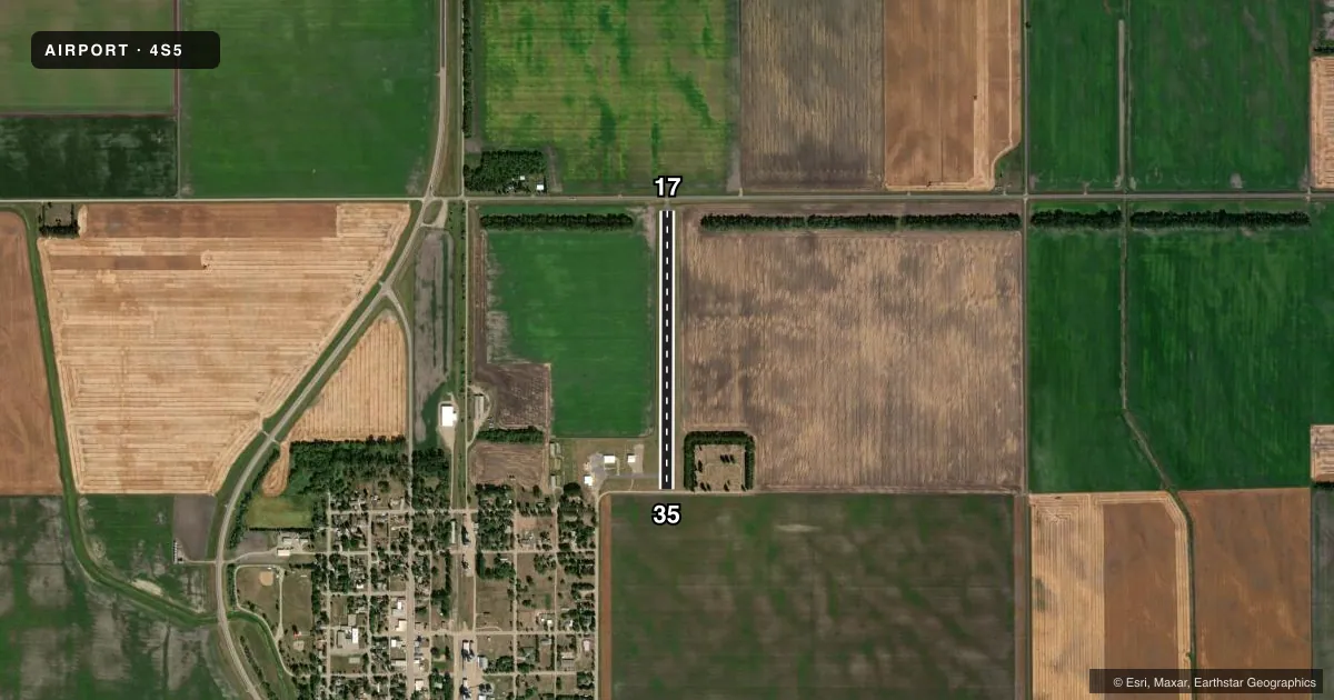
Full pagePattern entry · RWY 35
LEFT TRAFFICAirport sketch
Runways drawn to scale from FAA survey coordinates, rendered over satellite imagery. Not for navigation.
Approaches & charts
Services on the field
Fuel grades, oxygen, maintenance, ramp storage and lighting — as declared to the FAA by the airport operator.
Fuel & services
- Fuel
- Not available
- Airframe repair
- Not available
- Power plant repair
- Not available
- Other services
- AGRI
Ramp & ground
- Transient storage
- Tie-down
- Landing fee
- No fee published
- Customs
- Not available
- Lighting schedule
- SEE RMK
- Wind indicator
- Yes
- Segmented circle
- No
Fuel & FBOs
Cheapest 100LL and Jet A on the field and nearby. Always confirm with the FBO before taxi.
Airport notes
Surface conditions, obstructions, local procedures, lighting outages and other notes published with each FAA cycle.
General notes
- CFM WINTER CONDS & SN REMOVAL 701-360-7926.
- RWY 17/35; EXPECT TURBULENCE WHEN EXECUTING CROSS-WIND LNDGS DUE TO TREE LINES.
- DEER AND BIRDS ON & INVOF APRT
- FOR CD CTC MINNEAPOLIS ARTCC AT 651-463-5588.
Lighting notes
- ACTVT LIRL RY 17/35 - 122.9.
Runway surface & condition
- 17/35NSTD LIRL DUE TO FIXTURES & LCTD 25 FT FROM RWY EDGE.
Approach & departure obstructions
- 1718 FT ROAD 100 FT FM THLD.
- 3516 FT ROAD 20 FT FM THLD.
- 17DSPLCD THLD MKD WITH GREEN LGTS - NIGHT OPS ONLY.
- 35DSPLCD THLD MKD WITH GREEN LGTS - NIGHT OPS ONLY.
- 1760 FT TREE LINE 340 FT L AND R OF CNTRLN AT RWY 17 END PENETRATES 7:1 TRNSL SFC WITH A 3:1 SLOPE.
- 3550 FT TREE LINE 160 FT R OF CNTRLN AT RWY 35 END PENETRATES 7:1 TRNSL SFC WITH A 1:1 SLOPE.
- 1718 FT ROAD 380 FT FM DSPLCD THLD.
- 3516 FT ROAD 90 FT FM DSPLCD THLD.
VFR map & nearby airports
VFR sectional. Tap any ICAO chip to open that airport.
Key facts · 4S5
Answer card- ICAO
- 4S5
- Name
- ST THOMAS MUNI
- Location
- ST THOMAS, NORTH DAKOTA
- Elevation
- 839 ft MSL
- Traffic pattern altitude
- 1,839 ft MSL (1,000 AGL)
- Control tower
- Non-towered (use CTAF)
- Total runways
- 1
- Longest runway
- 17/35 · 2,600 ft
- Published ILS approaches
- 0
- Published frequencies
- 1
- Magnetic variation
- 7°
- Current flight rules
- VFR
- Current wind
- 350° at 8 kt
- Favored runway now
- RWY 35
ST THOMAS MUNI (4S5) sits in St Thomas, North Dakota. Field elevation is 839 ft MSL. The airport has one runway, 17/35, which is 2,600 ft long and asphalt. There is no control tower. CTAF is 122.9. No ILS approaches are published here.
Pattern altitude is not published. Use 1,000 ft AGL for light piston operations unless the current Chart Supplement says otherwise. That puts the pattern at about 1,839 ft MSL. The published remarks call out deer and birds on and near the airport. They also note turbulence on crosswind landings for runway 17/35 because of tree lines. That matters here. Expect a tighter feel than a larger field.
Runway 17 and runway 35 both have displaced thresholds marked with green lights for night use. There is also a road close to each end. The runway 35 end has a road 20 ft from the threshold. The runway 17 end has roads near the threshold and displaced threshold. A tree line near runway 35 and another near runway 17 penetrate the transitional surface. No on-field FBOs are listed. Check with the airport operator or the FBO directly by phone for current services before you go. For clearance delivery, contact Minneapolis ARTCC. Confirm winter conditions and snow removal before a cold-weather arrival.