METAR & TAF 2C8
Current METAR
Observed 20:35Z
K2C8 272035Z AUTO 01009KT 7SM FEW029 FEW034 29/24 A2982 RMK AO2
- Wind
- 010° @ 9 kt
- Visibility
- 7 SM
- Temp / Dew
- 29°C / 24°C
- Altimeter
- 29.82 inHg
- Clouds
- FEW
- Density alt
- 2,910 ft
- Ceiling
- Unlimited
- Rules
- VFR
Airport info & contacts
Manager on record, flight service, ARTCC, attendance schedule and pattern altitude — published by the FAA and refreshed every 28 days.
Location
- From city
- 1 NM SW
- VFR sectional
- TWIN CITIES
- ARTCC
- ZMP · MINNEAPOLIS
- NOTAM facility
- GFK (NOTAM-D)
Airport manager
- Name
- HAROLD MCCONNELL
- Phone
- 701-520-8631
- Address
- PO BOX 411, CAVALIER ND 58220
Flight service · Hours
- FSS GFK
- GRAND FORKS1-800-WX-BRIEF
- Attendance
- ON CALL
Frequencies
Tap any row to copy the frequency to your clipboard.
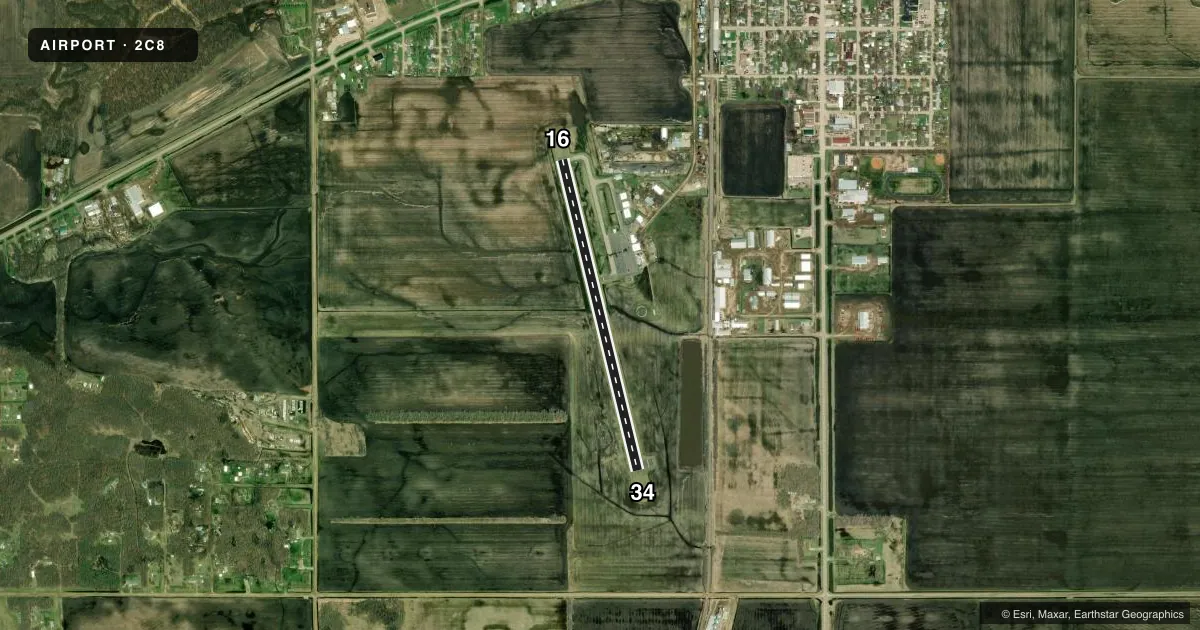
Runways & pattern
Full pagePattern entry · RWY 34
LEFT TRAFFICRunway end performance
| End | TORA | TODA | ASDA | LDA | VGSI | Approach lights | Obstruction |
|---|---|---|---|---|---|---|---|
| 16 | — | — | — | — | PAPI 2-box left(3°) | — | — |
| 34 | — | — | — | — | PAPI 2-box left(4°) | — | 72', bldg, 1645' from thr, 455' R of cntrln, slope 20 |
Declared distances in feet. TORA = takeoff run available, TODA = takeoff distance, ASDA = accelerate-stop, LDA = landing distance.
Airport sketch
Runways drawn to scale from FAA survey coordinates, rendered over satellite imagery. Not for navigation.
Approaches & charts
Services on the field
Fuel grades, oxygen, maintenance, ramp storage and lighting — as declared to the FAA by the airport operator.
Fuel & services
- Fuel
- 100LLA
- Oxygen (bottled)
- Not available
- Oxygen (bulk)
- Not available
- Airframe repair
- Not available
- Power plant repair
- Not available
- Other services
- AGRI,SALES
Ramp & ground
- Transient storage
- Tie-down
- Hangar
- Landing fee
- No fee published
- Customs
- Not available
- Lighting schedule
- SEE RMK
- Beacon schedule
- SS-SR
- Beacon
- White / Green (civil land)(WG)
- Wind indicator
- Lighted
- Segmented circle
- No
Fuel & FBOs
Cheapest 100LL and Jet A on the field and nearby. Always confirm with the FBO before taxi.
Airport notes
Surface conditions, obstructions, local procedures, lighting outages and other notes published with each FAA cycle.
General notes
- HELIPAD LOCATED SOUTH EDGE OF APRON.
- CFM SNOW REMOVAL WITH AMGR AFT WINT STORM.
- RY 34 +31' PLINE 1300' FM THLD ON CL; APCH RATIO 35:1.
- RY 16 +45' MARKED PLINE 1920' FM THLD ON CL; APCH RATIO 38:1.
- FOR CD CTC MINNEAPOLIS ARTCC AT 651-463-5588.
- LARGE BIRDS INVOF ARPT.
Lighting notes
- ACTVT REIL RWY 34; PAPI RWY 16 & 34; MIRL RWY 16/34 - CTAF.
Fuel notes
- 100LLSELF SVC FUEL AVBL H24 VIA CREDIT CARD.
Approach & departure obstructions
- 34PAPI UNUSBL BYD 5 DEGS RIGHT OF CNTRLN.
Other notes
- EXISTED PRIOR TO 1959.
- MANAGERADDL ARPT CONTACT JEREMY SENG 701-520-5066.
VFR map & nearby airports
VFR sectional. Tap any ICAO chip to open that airport.
Key facts · 2C8
Answer card- ICAO
- 2C8
- Name
- CAVALIER MUNI
- Location
- CAVALIER, NORTH DAKOTA
- Elevation
- 892.1 ft MSL
- Traffic pattern altitude
- 1,892.1 ft MSL (1,000 AGL)
- Control tower
- Non-towered (use CTAF)
- Total runways
- 1
- Longest runway
- 16/34 · 3,299 ft
- Published ILS approaches
- 0
- Published frequencies
- 2
- Magnetic variation
- 6°
- Current flight rules
- VFR
- Current wind
- 010° at 9 kt
- Favored runway now
- RWY 34
Cavalier Muni sits in Cavalier, North Dakota. The field elevation is 892.1 ft MSL. It has one runway, 16/34, which is 3,299 ft of asphalt. There is no control tower. CTAF and UNICOM are both 122.8. No ILS approaches are published here.
Pattern altitude is not published. Use 1,000 ft AGL as the standard light-piston pattern unless local procedures or current airport guidance say otherwise. The airport carries a magnetic variation of 6°. If you are planning a first visit, pay attention to the runway environment. Runway 34 has a painted plus 31 feet line 1,300 ft from the threshold on centerline. Runway 16 has a painted plus 45 feet line 1,920 ft from the threshold on centerline. Large birds are reported in the vicinity. Confirm snow removal with the airport manager after winter storms.
Cavalier Municipal Airport is the on-field FBO. It carries 100LL and Jet A Prist. Self-service 100LL is available 24 hours a day by credit card. Runway 34 has REILs. Both runways 16 and 34 have PAPI. Medium intensity runway lights are controlled by CTAF. For clearance delivery, contact Minneapolis ARTCC. The helipad is on the south edge of the apron.