METAR & TAF 96D
Current METAR
Observed 18:35Z
K96D 271835Z AUTO 01008G13KT 10SM FEW025 FEW030 28/23 A2983 RMK AO2
- Wind
- 010° @ 8G13 kt
- Visibility
- 10 SM
- Temp / Dew
- 28°C / 23°C
- Altimeter
- 29.83 inHg
- Clouds
- FEW
- Density alt
- 2,853 ft
- Ceiling
- Unlimited
- Rules
- VFR
Airport info & contacts
Manager on record, flight service, ARTCC, attendance schedule and pattern altitude — published by the FAA and refreshed every 28 days.
Location
- From city
- 1 NM NE
- VFR sectional
- TWIN CITIES
- ARTCC
- ZMP · MINNEAPOLIS
- NOTAM facility
- 96D (NOTAM-D)
Airport manager
- Name
- DAVID CARIGNAN
- Phone
- 701-265-2617
- Address
- PO BOX 306, WALHALLA ND 58282
Flight service · Hours
- FSS GFK
- GRAND FORKS1-800-WX-BRIEF
- Attendance
- OCT-MAR · ON CALL
- APR-SEP · M-F · DAWN-DUSK
Frequencies
Tap any row to copy the frequency to your clipboard.
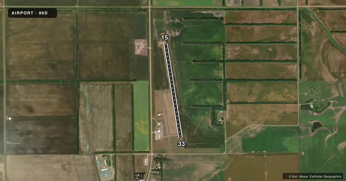
Runways & pattern
Full pagePattern entry · RWY 33
LEFT TRAFFICRunway end performance
| End | TORA | TODA | ASDA | LDA | VGSI | Approach lights | Obstruction |
|---|---|---|---|---|---|---|---|
| 15 | — | — | — | — | PAPI 2-box left(3°) | — | 40', pline, 1210' from thr, 215' R of cntrln, slope 20 |
| 33 | — | — | — | — | PAPI 2-box left(3°) | — | — |
Declared distances in feet. TORA = takeoff run available, TODA = takeoff distance, ASDA = accelerate-stop, LDA = landing distance.
Airport sketch
Runways drawn to scale from FAA survey coordinates, rendered over satellite imagery. Not for navigation.
Approaches & charts
Services on the field
Fuel grades, oxygen, maintenance, ramp storage and lighting — as declared to the FAA by the airport operator.
Fuel & services
- Fuel
- 100LL
- Oxygen (bottled)
- Not available
- Oxygen (bulk)
- Not available
- Airframe repair
- Not available
- Power plant repair
- Not available
- Other services
- AGRI
Ramp & ground
- Transient storage
- Tie-down
- Landing fee
- No fee published
- Customs
- Not available
- Lighting schedule
- SEE RMK
- Wind indicator
- No
- Segmented circle
- No
Fuel & FBOs
Cheapest 100LL and Jet A on the field and nearby. Always confirm with the FBO before taxi.
Airport notes
Surface conditions, obstructions, local procedures, lighting outages and other notes published with each FAA cycle.
General notes
- CFM WINTER CONDS & SN REMOVAL CALL 701-265-2617.
- DEER AND BIRDS ON OR INVOF ARPT.
- FOR CD CTC MINNEAPOLIS ARTCC AT 651-463-5588.
- RWY 15 40 FT POWERLINE 1210 FT FM THR 25:1 SLOPE.
Lighting notes
- ACTVT MIRL RY 15/33 & PAPI RY 15 & 33 - CTAF.
Fuel notes
- 100LLSELF SVC AVBL 24 HR WITH CREDIT CARD.
Other notes
- EXISTED PRIOR TO 1959.
- 1FOR ATTENDANT OTR HRS CALL 701-549-3500.
- MANAGERADDITIONAL CONTACT JASON BERG - 701-521-0514
VFR map & nearby airports
VFR sectional. Tap any ICAO chip to open that airport.
Key facts · 96D
Answer card- ICAO
- 96D
- Name
- WALHALLA MUNI
- Location
- WALHALLA, NORTH DAKOTA
- Elevation
- 953 ft MSL
- Traffic pattern altitude
- 1,953 ft MSL (1,000 AGL)
- Control tower
- Non-towered (use CTAF)
- Total runways
- 1
- Longest runway
- 15/33 · 3,400 ft
- Published ILS approaches
- 0
- Published frequencies
- 1
- Magnetic variation
- 7°
- Current flight rules
- VFR
- Current wind
- 010° at 8 kt
- Favored runway now
- RWY 33
Walhalla Muni sits in Walhalla, North Dakota. Field elevation is 953 ft MSL. The airport has one runway. Runway 15/33 is 3,400 ft long and paved with asphalt. There is no control tower. CTAF is 122.9.
No ILS approaches are published here. Pattern altitude is not published, so use the standard 1,000 ft AGL pattern unless the current Chart Supplement or local procedures say otherwise. That puts the light-piston pattern at about 1,953 ft MSL based on the field elevation. The runway lighting is medium intensity on 15/33. PAPI is available on both ends and is activated through CTAF.
Walhalla Aviation is on the field. It carries 100LL. Self-serve 100LL is available 24 hours with a credit card. If you need an attendant outside regular hours, call the number listed for the field. The published remarks also call out a 40-foot powerline near runway 15 about 1,210 ft from the threshold. Deer and birds are reported in the area. Winter conditions and snow removal should be confirmed before arrival. For IFR clearance delivery, Minneapolis ARTCC is the published contact.