METAR & TAF KGAF
Current METAR
Observed 23:15Z
KGAF 272315Z AUTO 02009KT 9SM CLR 29/21 A2981 RMK AO2 PWINO
- Wind
- 020° @ 9 kt
- Visibility
- 9 SM
- Temp / Dew
- 29°C / 21°C
- Altimeter
- 29.81 inHg
- Clouds
- CLR
- Density alt
- 2,839 ft
- Ceiling
- Unlimited
- Rules
- VFR
Airport info & contacts
Manager on record, flight service, ARTCC, attendance schedule and pattern altitude — published by the FAA and refreshed every 28 days.
Location
- From city
- 2 NM ESE
- VFR sectional
- TWIN CITIES
- ARTCC
- ZMP · MINNEAPOLIS
- NOTAM facility
- GFK (NOTAM-D)
Airport manager
- Name
- BRIAN EROVICK
- Phone
- 701-331-4220
- Address
- 15182 HWY 17, GRAFTON ND 58237
Flight service · Hours
- FSS GFK
- GRAND FORKS1-800-WX-BRIEF
- Attendance
- MON-FRI · DALGT
- SAT-SUN · ON CALL
Frequencies
Tap any row to copy the frequency to your clipboard.
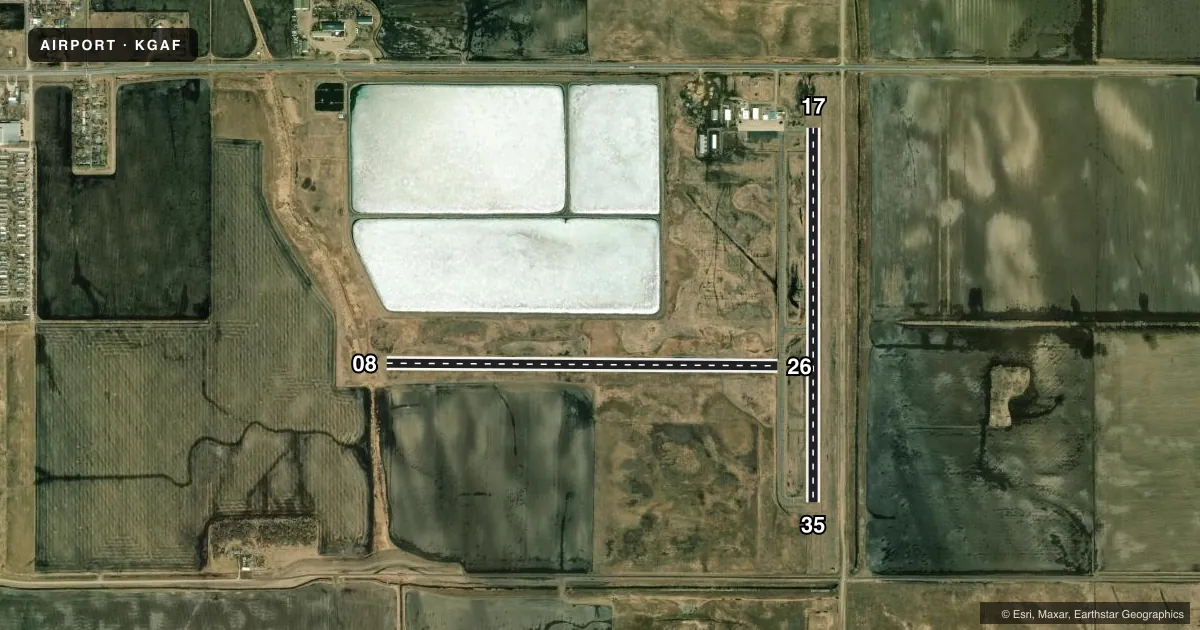
Runways & pattern
Full pagePattern entry · RWY 35
LEFT TRAFFIC| Runway | Heading (°M) | Length | Surface | Traffic |
|---|---|---|---|---|
| 08/26 | 84° / 264° | 4,074 ft | TURF | Standard L |
| 17/35Favored | 174° / 354° | 3,898 ft | ASPH | Standard L |
Runway end performance
| End | TORA | TODA | ASDA | LDA | VGSI | Approach lights | Obstruction |
|---|---|---|---|---|---|---|---|
| 17 | — | — | — | — | PAPI 2-box left(3°) | — | — |
| 35 | — | — | — | — | PAPI 2-box left(3°) | — | — |
Declared distances in feet. TORA = takeoff run available, TODA = takeoff distance, ASDA = accelerate-stop, LDA = landing distance.
Airport sketch
Runways drawn to scale from FAA survey coordinates, rendered over satellite imagery. Not for navigation.
Approaches & charts
Services on the field
Fuel grades, oxygen, maintenance, ramp storage and lighting — as declared to the FAA by the airport operator.
Fuel & services
- Fuel
- 100LLA
- Oxygen (bottled)
- Not available
- Oxygen (bulk)
- Not available
- Airframe repair
- Not available
- Power plant repair
- Not available
- Other services
- AGRI,INSTR
Ramp & ground
- Transient storage
- Tie-down
- Hangar
- Landing fee
- No fee published
- Customs
- Not available
- Lighting schedule
- SEE RMK
- Beacon schedule
- SS-SR
- Beacon
- White / Green (civil land)(WG)
- Wind indicator
- Lighted
- Segmented circle
- No
Fuel & FBOs
Cheapest 100LL and Jet A on the field and nearby. Always confirm with the FBO before taxi.
Airport notes
Surface conditions, obstructions, local procedures, lighting outages and other notes published with each FAA cycle.
General notes
- BE ALERT: 3 FT DITCH BTN EAST END 8/26 & 17/35, USE DSGND TWYS.
- LARGE BIRDS AND DEER ON OR INVOF ARPT.
- HVY AERIAL SPRAY ACTIVITY MAY-OCT.
- CFM WINTER CONDS & SNOW REMOVAL WITH AMGR CALL 701-331-4220/701-360-1365.
- NMRS TSNT FLT TRNG ACTIVITIES.
- RWY 08/26 CLSD WINTER MONTHS DUE TO LACK OF SNOW REMOVAL.
- RWY 08 HAS +3' DITCH 213' FM THRSHOLD
- FOR CD CTC MINNEAPOLIS ARTCC AT 651-463-5588.
Lighting notes
- PAPI RWY 17 & 35, MIRL RWY 17/35 PRESET ON LOW INTST DUSK-2300; TO INCR INTST AFT 2300 ACTVT - CTAF.
Fuel notes
- 100LL24-HR SELF SVC FUEL AVBL WITH CREDIT CARD ONLY.
Approach & departure obstructions
- 08RWY 08/26 - MKD WITH WHITE DALGT END MKRS.
Other notes
- 1FOR SVC AFT HRS CALL 701-331-4220.
- OWNERCHAIRMAN ARPT AUTH RANDY SCHUSTER.
- 08/26TURF SOFT WHEN WET.
VFR map & nearby airports
VFR sectional. Tap any ICAO chip to open that airport.
Key facts · KGAF
Answer card- ICAO
- KGAF
- Name
- HUTSON FLD
- Location
- GRAFTON, NORTH DAKOTA
- Elevation
- 824.5 ft MSL
- Traffic pattern altitude
- 1,824.5 ft MSL (1,000 AGL)
- Control tower
- Non-towered (use CTAF)
- Total runways
- 2
- Longest runway
- 08/26 · 4,074 ft
- Published ILS approaches
- 0
- Published frequencies
- 4
- Magnetic variation
- 6°
- Current flight rules
- VFR
- Current wind
- 020° at 9 kt
- Favored runway now
- RWY 35
Hutson Fld sits in Grafton, North Dakota. Field elevation is 824.5 ft MSL. The airport has two runways. The longest is runway 08/26 at 4,074 ft. Runway 17/35 is 3,898 ft asphalt. There is no control tower. CTAF and UNICOM are both 122.8.
No ILS approaches are published here. Pattern altitude is not published, so use the standard 1,000 ft AGL for light piston operations unless the current FAA Chart Supplement says otherwise. The on-field FBO is Agrimax. It carries 100LL and Jet A Prist. Twenty-four-hour self-serve fuel is available with credit card only.
A few local items matter on a first visit. Runway 08/26 is closed during winter months because snow removal is not provided. The turf can be soft when wet. Runway 08 has a ditch about 213 ft from the threshold. PAPI is available on runways 17 and 35. The lights on 17 and 35 come up at low intensity from dusk to 2300. After 2300, activate them on CTAF if you need more intensity. Heavy aerial spray activity runs from May through October. Large birds and deer are reported near the field. Numerous transient flight training operations also use the airport. For clearance delivery, contact Minneapolis ARTCC.