METAR & TAF KBAC
Current METAR
Observed 22:35Z
KBAC 272235Z AUTO 34011KT 9SM CLR 32/21 A2986 RMK AO2
- Wind
- 340° @ 11 kt
- Visibility
- 9 SM
- Temp / Dew
- 32°C / 21°C
- Altimeter
- 29.86 inHg
- Clouds
- CLR
- Density alt
- 3,853 ft
- Ceiling
- Unlimited
- Rules
- VFR
Airport info & contacts
Manager on record, flight service, ARTCC, attendance schedule and pattern altitude — published by the FAA and refreshed every 28 days.
Location
- From city
- 1 NM NW
- VFR sectional
- TWIN CITIES
- ARTCC
- ZMP · MINNEAPOLIS
- NOTAM facility
- GFK (NOTAM-D)
Airport manager
- Name
- MIKE LERUD
- Phone
- 701-840-5903
- Address
- P.O. BOX 2, VALLEY CITY ND 58072
Flight service · Hours
- FSS GFK
- GRAND FORKS1-800-WX-BRIEF
- Attendance
- MON-FRI · 0800-1700
- SAT-SUN · ON CALL
Frequencies
Tap any row to copy the frequency to your clipboard.
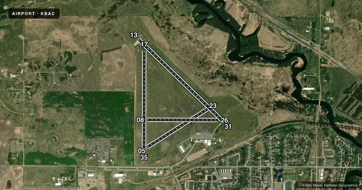
Runways & pattern
Full pagePattern entry · RWY 35
LEFT TRAFFIC| Runway | Heading (°M) | Length | Surface | Traffic |
|---|---|---|---|---|
| 13/31 | 127° / 307° | 4,201 ft | CONC | Standard L |
| 17/35Favored | 173° / 353° | 3,539 ft | TURF | Standard L |
| 05/23 | 51° / 231° | 2,525 ft | TURF | Standard L |
| 08/26 | 83° / 263° | 2,520 ft | TURF | Standard L |
Runway end performance
| End | TORA | TODA | ASDA | LDA | VGSI | Approach lights | Obstruction |
|---|---|---|---|---|---|---|---|
| 13 | — | — | — | — | PAPI 2-box left(3°) | — | — |
| 31 | — | — | — | — | PAPI 2-box left(3°) | — | — |
Declared distances in feet. TORA = takeoff run available, TODA = takeoff distance, ASDA = accelerate-stop, LDA = landing distance.
Airport sketch
Runways drawn to scale from FAA survey coordinates, rendered over satellite imagery. Not for navigation.
Approaches & charts
Services on the field
Fuel grades, oxygen, maintenance, ramp storage and lighting — as declared to the FAA by the airport operator.
Fuel & services
- Fuel
- 100LLA
- Oxygen (bottled)
- Not available
- Oxygen (bulk)
- Not available
- Airframe repair
- Major
- Power plant repair
- Major
- Other services
- AGRI,AMB,AVNCS,CHTR,INSTR,RNTL,SALES
Ramp & ground
- Transient storage
- Tie-down
- Hangar
- Landing fee
- No fee published
- Customs
- Not available
- Lighting schedule
- SEE RMK
- Beacon schedule
- SS-SR
- Beacon
- White / Green (civil land)(WG)
- Wind indicator
- Lighted
- Segmented circle
- Yes
Fuel & FBOs
Cheapest 100LL and Jet A on the field and nearby. Always confirm with the FBO before taxi.
Airport notes
Surface conditions, obstructions, local procedures, lighting outages and other notes published with each FAA cycle.
General notes
- RWY 05/23, 08/26 & 17/35 CLSD WINTER MONTHS DUE TO LACK OF SNOW REMOVAL
- CONFIRM SNOW REMOVAL & WINTER CONDS NOV-MAR, CALL 701-840-5903.
- BIRDS & DEER ON & INVOF ARPT.
- FOR CD CTC MINNEAPOLIS ARTCC AT 651-463-5588.
- GLD ACT ON & INVOF ARPT.
Lighting notes
- MIRL RWY 13/31 PRESET ON MED INTST; TO INCR INTST AND ACTVT PAPI RWY 13 & 31 - CTAF.
Fuel notes
- 100LLFUEL AVBL H24 SELF SVC VIA CREDIT CARD.
- AFUEL AVBL H24 SELF SVC VIA CREDIT CARD.
Approach & departure obstructions
- 35+35'PLINE MRKD WITH DALGT BALLS 1000' FM THR APCH RATIO 28:1.
Other notes
- 1ARPT ATTENDANT AFT HRS CALL 701-840-5903.
- OWNERARPT AUTH CHAIRPERSON - SHAWN ANDERSON.
- AGRIFOR ARPT SVCS CTC 701-845-2100.
VFR map & nearby airports
VFR sectional. Tap any ICAO chip to open that airport.
Key facts · KBAC
Answer card- ICAO
- KBAC
- Name
- BARNES COUNTY MUNI
- Location
- VALLEY CITY, NORTH DAKOTA
- Elevation
- 1,401.7 ft MSL
- Traffic pattern altitude
- 2,401.7 ft MSL (1,000 AGL)
- Control tower
- Non-towered (use CTAF)
- Total runways
- 4
- Longest runway
- 13/31 · 4,201 ft
- Published ILS approaches
- 0
- Published frequencies
- 2
- Magnetic variation
- 7°
- Current flight rules
- VFR
- Current wind
- 340° at 11 kt
- Favored runway now
- RWY 35
Barnes County Muni is in Valley City, North Dakota. The field elevation is 1,401.7 ft MSL. KBAC has four runways. The longest is runway 13/31 at 4,201 ft of concrete. The airport is non-towered. CTAF and UNICOM are both 122.8. No ILS approaches are published here.
The pattern altitude is not published. Use standard 1,000 ft AGL for light piston traffic unless the current Chart Supplement says otherwise. The published remarks matter here. Runways 05/23, 08/26 and 17/35 are closed during winter months because snow removal is not provided. Call ahead for winter conditions from November through March. A 35-foot power line is marked with daylight balls on the 35 approach side. Birds and deer are also reported in the area.
The on-field FBO is Barnes County Municipal Airport. It carries 100LL and Jet A. Self-serve fuel is available 24 hours a day by credit card. For airport services, the published contact number is 701-845-2100. If you need after-hours help, call 701-840-5903. The airport sits in open North Dakota terrain, so winter performance and crosswind planning deserve attention. Check the current Chart Supplement before departure for the latest runway and operational notes.