METAR & TAF 5N4
5N4 does not publish a METAR.
Showing the nearest reporting station: KGWR (GWINNER/ROGER MELROE FLD) · 24.6 NM away. Conditions at 5N4 may differ.
METAR · KGWR
Observed 21:35Z
KGWR 272135Z AUTO 30006KT 9SM CLR 31/22 A2983 RMK A01
- Wind
- 300° @ 6 kt
- Visibility
- 9 SM
- Temp / Dew
- 31°C / 22°C
- Altimeter
- 29.83 inHg
- Clouds
- CLR
- Density alt
- 3,459 ft
- Ceiling
- Unlimited
- Rules
- VFR
Airport info & contacts
Manager on record, flight service, ARTCC, attendance schedule and pattern altitude — published by the FAA and refreshed every 28 days.
Location
- From city
- 1 NM W
- VFR sectional
- TWIN CITIES
- Pattern altitude
- 653 ft AGL · 1,804 ft MSL
- ARTCC
- ZMP · MINNEAPOLIS
- NOTAM facility
- GFK (NOTAM-D)
Airport manager
- Name
- BOBBY GESKE
- Phone
- 701-799-6082
- Address
- 13923 53RD ST SE, ENDERLIN ND 58027
Flight service · Hours
- FSS GFK
- GRAND FORKS1-800-WX-BRIEF
- Attendance
- Unattended
Frequencies
Tap any row to copy the frequency to your clipboard.
Runways & pattern
Full pagePattern entry · RWY 30
LEFT TRAFFICRunway end performance
| End | TORA | TODA | ASDA | LDA | VGSI | Approach lights | Obstruction |
|---|---|---|---|---|---|---|---|
| 12 | — | — | — | — | — | — | 13', road, 380' from thr, 130' R of cntrln, slope 13 |
Declared distances in feet. TORA = takeoff run available, TODA = takeoff distance, ASDA = accelerate-stop, LDA = landing distance.
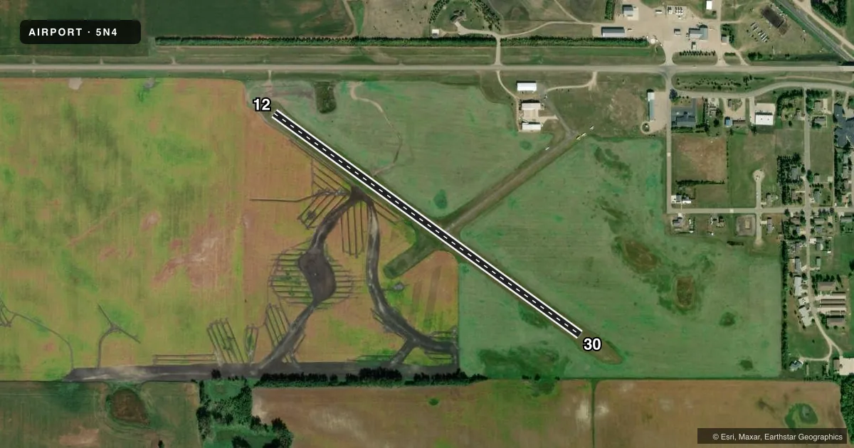
Airport sketch
Runways drawn to scale from FAA survey coordinates, rendered over satellite imagery. Not for navigation.
Approaches & charts
Services on the field
Fuel grades, oxygen, maintenance, ramp storage and lighting — as declared to the FAA by the airport operator.
Fuel & services
- Fuel
- 100LL
- Oxygen (bottled)
- Not available
- Oxygen (bulk)
- Not available
- Airframe repair
- Not available
- Power plant repair
- Not available
- Other services
- AGRI,INSTR
Ramp & ground
- Transient storage
- Tie-down
- Hangar
- Landing fee
- No fee published
- Customs
- Not available
- Lighting schedule
- SEE RMK
- Wind indicator
- Lighted
- Segmented circle
- No
Fuel & FBOs
Cheapest 100LL and Jet A on the field and nearby. Always confirm with the FBO before taxi.
Airport notes
Surface conditions, obstructions, local procedures, lighting outages and other notes published with each FAA cycle.
General notes
- ELECTRICAL HOOKUP FOR ACFT FOR WINTERTIME USE NEXT TO PILOT LOUNGE.
- RWY 12/30 THLD LGTS 86 FT OUTSIDE RWY 30 END; EDGE LGTS 28 FT FM RWY EDGES.
- CFM WINTER CONDS & SN REMOVAL WITH AMGR.
- BIRDS & DEER ON & INVOF ARPT.
- FOR CD CTC MINNEAPOLIS ARTCC AT 651-463-5588.
Lighting notes
- ACTVT LIRL RWY 12/30 - CTAF.
Other notes
- OWNERCHAIRMAN OF ARPT AUTH BOBBY GESKE.
- MANAGERAMGR ADNL PHONE 701-437-3437.
VFR map & nearby airports
VFR sectional. Tap any ICAO chip to open that airport.
Key facts · 5N4
Answer card- ICAO
- 5N4
- Name
- SKY HAVEN
- Location
- ENDERLIN, NORTH DAKOTA
- Elevation
- 1,151 ft MSL
- Traffic pattern altitude
- 1,804 ft MSL (653 AGL)
- Control tower
- Non-towered (use CTAF)
- Total runways
- 1
- Longest runway
- 12/30 · 2,855 ft
- Published ILS approaches
- 0
- Published frequencies
- 1
- Magnetic variation
- 7°
- Current flight rules
- VFR
- Current wind
- 300° at 6 kt
- Favored runway now
- RWY 30
SKY HAVEN is in Enderlin, North Dakota. The field elevation is 1,151 ft MSL. It has one runway. Runway 12/30 is 2,855 ft long and asphalt. There is no control tower. CTAF is 122.9. Pattern altitude is 653 ft AGL, which is 1,804 ft MSL.
No ILS approaches are published here. That makes the current chart data worth checking before you go, especially if weather is marginal. The runway lights on 12/30 are low intensity and are activated by CTAF. For winter operations, confirm snow removal with the airport manager. Electrical hookup for aircraft is next to the pilot lounge for winter use.
The field has birds and deer in the area. Plan your arrival and departure with that in mind. The runway threshold lights on 12/30 sit 86 ft outside the runway 30 end. Edge lights are 28 ft from the runway edges. There are no on-field FBOs listed. Contact the airport operator directly before arrival, or call the field on CTAF for current fuel or service availability. For clearance delivery, Minneapolis ARTCC can be reached at 651-463-5588.