METAR & TAF KROX
Current METAR
Observed 07:15Z
KROX 280715Z AUTO 06003KT 1SM BR CLR 17/17 A2988 RMK AO2 T01720172
- Wind
- 060° @ 3 kt
- Visibility
- 1 SM
- Temp / Dew
- 17°C / 17°C
- Altimeter
- 29.88 inHg
- Clouds
- CLR
- Density alt
- 1,604 ft
- Ceiling
- Unlimited
- Rules
- IFR
Airport info & contacts
Manager on record, flight service, ARTCC, attendance schedule and pattern altitude — published by the FAA and refreshed every 28 days.
Location
- From city
- 2 NM E
- VFR sectional
- TWIN CITIES
- ARTCC
- ZMP · MINNEAPOLIS
- NOTAM facility
- ROX (NOTAM-D)
Airport manager
- Name
- TODD PETERSON
- Phone
- 218-689-0047
- Address
- 121 CENTER ST E, PO BOX 307, ROSEAU MN 56751-0307
Flight service · Hours
- FSS PNM
- PRINCETON1-800-WX-BRIEF
- Attendance
- Unattended
Frequencies
Tap any row to copy the frequency to your clipboard.
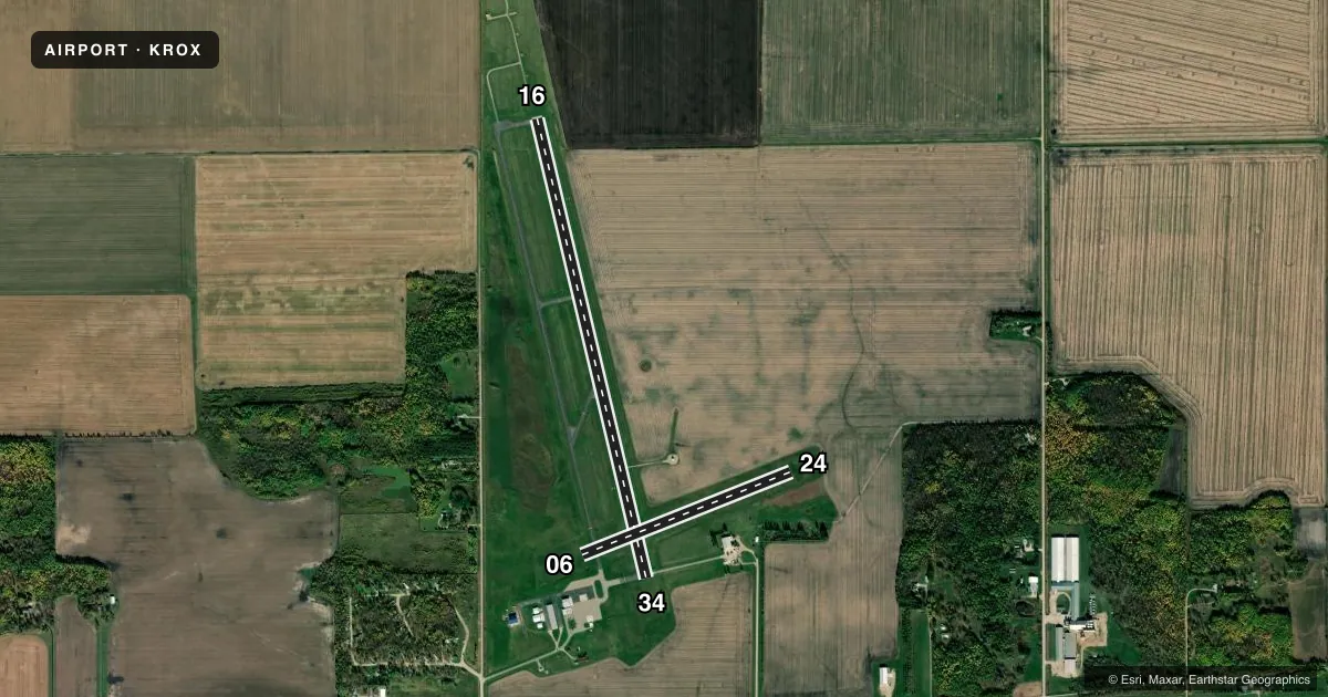
Runways & pattern
Full pagePattern entry · RWY 06
LEFT TRAFFIC| Runway | Heading (°M) | Length | Surface | Traffic |
|---|---|---|---|---|
| 16/34 | 164° / 344° | 4,400 ft | ASPH | Standard L |
| 06/24Favored | 67° / 247° | 2,097 ft | TURF | Standard L |
Runway end performance
| End | TORA | TODA | ASDA | LDA | VGSI | Approach lights | Obstruction |
|---|---|---|---|---|---|---|---|
| 16 | — | — | — | — | PAPI 2-box left(3°) | MALSF | — |
| 34 | — | — | — | — | PAPI 2-box left(3°) | — | — |
Declared distances in feet. TORA = takeoff run available, TODA = takeoff distance, ASDA = accelerate-stop, LDA = landing distance.
Airport sketch
Runways drawn to scale from FAA survey coordinates, rendered over satellite imagery. Not for navigation.
Approaches & charts
Services on the field
Fuel grades, oxygen, maintenance, ramp storage and lighting — as declared to the FAA by the airport operator.
Fuel & services
- Fuel
- 100LLA
- Oxygen (bottled)
- Not available
- Oxygen (bulk)
- Not available
- Airframe repair
- Not available
- Power plant repair
- Not available
- Other services
- AGRI,AMB,SALES
Ramp & ground
- Transient storage
- Tie-down
- Hangar
- Landing fee
- No fee published
- Customs
- Not available
- Lighting schedule
- SEE RMK
- Beacon schedule
- SS-SR
- Beacon
- White / Green (civil land)(WG)
- Wind indicator
- Lighted
- Segmented circle
- Yes
Fuel & FBOs
Cheapest 100LL and Jet A on the field and nearby. Always confirm with the FBO before taxi.
Airport notes
Surface conditions, obstructions, local procedures, lighting outages and other notes published with each FAA cycle.
General notes
- FOR CD IF UNA TO CTC ON FSS FREQ, CTC MINNEAPOLIS ARTCC AT 651-463-5588.
Lighting notes
- ACTVT OR INCR INTST MALSF RWY 16; NSTD REIL RWY 34; PAPI RWY 16 & 34; MIRL RWY 16/34 - CTAF. NSTD REIL RWY 34 OPR CONSLY DUSK-0000; MIRL RWY 16/34 PRESET LOW INTST.
Fuel notes
- 100LLFUEL AVBL H24 VIA CREDIT CARD.
Runway surface & condition
- 06/24CLSD WINTER MONTHS.
Approach & departure obstructions
- 34REIL NSTD DUE TO PCL 7 CLICKS ON, NO 3 OR 5 CLICK OPRN.
- 16SEASONAL.
VFR map & nearby airports
VFR sectional. Tap any ICAO chip to open that airport.
Key facts · KROX
Answer card- ICAO
- KROX
- Name
- ROSEAU MUNI/RUDY BILLBERG FLD
- Location
- ROSEAU, MINNESOTA
- Elevation
- 1,060.3 ft MSL
- Traffic pattern altitude
- 2,060.3 ft MSL (1,000 AGL)
- Control tower
- Non-towered (use CTAF)
- Total runways
- 2
- Longest runway
- 16/34 · 4,400 ft
- Published ILS approaches
- 0
- Published frequencies
- 2
- Magnetic variation
- 2°
- Current flight rules
- IFR
- Current wind
- 060° at 3 kt
- Favored runway now
- RWY 06
Roseau Muni/Rudy Billberg Fld (KROX) sits in Roseau, Minnesota. Field elevation is 1,060.3 ft MSL. The airport has two runways. The longest is 16/34 at 4,400 ft. Runway 06/24 is turf at 2,097 ft. There is no control tower. CTAF and UNICOM are both 122.8.
No ILS approaches are published here. Pattern altitude is not published, so use the standard 1,000 ft AGL for light piston traffic unless the current Chart Supplement says otherwise. The on-field FBO is Roseau Municipal Airport. It carries 100LL and Jet A. Fuel is available 24 hours a day by credit card.
A few operational items matter here. Runway 06/24 is closed during winter months. Runway 16 has seasonal obstructions. Runway 34 has nonstandard REIL behavior. The published lighting notes also say the MIRL on 16/34 is pilot-controlled through CTAF, with low intensity preset. PAPI is available on 16 and 34. For clearance delivery issues, the published remarks direct pilots to Minneapolis ARTCC if Flight Service cannot be reached. This is a small non-towered field, so plan your radio work and runway choice with the seasonal runway status and lighting notes in mind.