METAR & TAF 43Y
43Y does not publish a METAR.
Showing the nearest reporting station: KVWU (WASKISH MUNI) · 18.8 NM away. Conditions at 43Y may differ.
METAR · KVWU
Observed 00:35Z
KVWU 280035Z AUTO 00000KT 10SM CLR 28/22 A2981 RMK AO2
- Wind
- 000° @ 0 kt
- Visibility
- 10 SM
- Temp / Dew
- 28°C / 22°C
- Altimeter
- 29.81 inHg
- Clouds
- CLR
- Density alt
- 3,470 ft
- Ceiling
- Unlimited
- Rules
- VFR
Airport info & contacts
Manager on record, flight service, ARTCC, attendance schedule and pattern altitude — published by the FAA and refreshed every 28 days.
Location
- From city
- 2 NM NE
- VFR sectional
- TWIN CITIES
- ARTCC
- ZMP · MINNEAPOLIS
- NOTAM facility
- PNM (NOTAM-D)
Airport manager
- Name
- PETER BENDER
- Phone
- 218-434-1743
- Address
- PO BOX 65, 12068 MAIN ST, NORTHOME MN 56661-0065
Flight service · Hours
- FSS PNM
- PRINCETON1-800-WX-BRIEF
- Attendance
- Unattended
Frequencies
Tap any row to copy the frequency to your clipboard.
Runways & pattern
Full pagePattern entry · RWY 12
LEFT TRAFFIC| Runway | Heading (°M) | Length | Surface | Traffic |
|---|---|---|---|---|
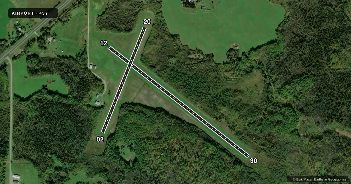
| 12/30 | 124° / 304° | 3,199 ft | TURF | Standard L |
| 02/20 | 18° / 198° | 2,049 ft | TURF | Standard L |
Runway end performance
| End | TORA | TODA | ASDA | LDA | VGSI | Approach lights | Obstruction |
|---|---|---|---|---|---|---|---|
| 12 | — | — | — | — | — | — | 68', tree, 1283' from thr, 292' R of cntrln, slope 18 |
| 30 | — | — | — | — | — | — | 74', trees, 1299' from thr, 154' R of cntrln, slope 17 |
| 02 | — | — | — | — | — | — | 29', trees, 394' from thr, 201' R of cntrln, slope 13 |
| 20 | — | — | — | — | — | — | 54', trees, 745' from thr, 146' R of cntrln, slope 13 |
Declared distances in feet. TORA = takeoff run available, TODA = takeoff distance, ASDA = accelerate-stop, LDA = landing distance.
Airport sketch
Runways drawn to scale from FAA survey coordinates, rendered over satellite imagery. Not for navigation.
Approaches & charts
Services on the field
Fuel grades, oxygen, maintenance, ramp storage and lighting — as declared to the FAA by the airport operator.
Fuel & services
- Fuel
- Not available
Ramp & ground
- Transient storage
- Tie-down
- Landing fee
- No fee published
- Lighting schedule
- SS-SR
- Beacon schedule
- SS-SR
- Beacon
- White / Green (civil land)(WG)
- Wind indicator
- Lighted
- Segmented circle
- No
Fuel & FBOs
Cheapest 100LL and Jet A on the field and nearby. Always confirm with the FBO before taxi.
Airport notes
Surface conditions, obstructions, local procedures, lighting outages and other notes published with each FAA cycle.
General notes
- FOR CD CTC MINNEAPOLIS ARTCC AT 651-463-5588.
Runway surface & condition
- 02/20NOT MNTND WINTER MONTHS.
- 12/30NSTD LIRL DUE TO VRB SPACING, NMRS RWY EDGE LGTS INOP.
Approach & departure obstructions
- 02UNEVEN SFC NEAR RWY END.
- 02YELLOW CONES.
- 12YELLOW CONES.
- 20RWY & DTHR MKD WITH YELLOW CONES.
- 30YELLOW CONES.
Other notes
- PRVDD THRS ARE LCTD & CLEARLY MKD TO PRVD A MNM 20:1 CLNC OVR ALL OBSTNS.
- TIEDOWNS NOT MKD.
- MANAGERNORTHOME@PAULBUNYAN.NET.
- 12/30RUTS IN RWY.
VFR map & nearby airports
VFR sectional. Tap any ICAO chip to open that airport.
Key facts · 43Y
Answer card- ICAO
- 43Y
- Name
- NORTHOME MUNI
- Location
- NORTHOME, MINNESOTA
- Elevation
- 1,430 ft MSL
- Traffic pattern altitude
- 2,430 ft MSL (1,000 AGL)
- Control tower
- Non-towered (use CTAF)
- Total runways
- 2
- Longest runway
- 12/30 · 3,199 ft
- Published ILS approaches
- 0
- Published frequencies
- 1
- Magnetic variation
- 4°
- Current flight rules
- VFR
- Current wind
- 000° at 0 kt
- Favored runway now
- –
Northome Muni sits in Northome, Minnesota. The field elevation is 1,430 ft MSL. It has two turf runways. The longest is 12/30 at 3,199 ft. There is no control tower. CTAF is 122.9. No ILS approaches are published.
Pattern altitude is not published. Use the standard 1,000 ft AGL for light piston operations unless the current Chart Supplement says otherwise. That puts the pattern at 2,430 ft MSL for a normal light-aircraft pattern. Runway 12/30 has reported ruts. The runway 12 and 30 ends are marked with yellow cones. Runway 02/20 is not maintained during winter months. The 02 end is marked with yellow cones. The 20 end and displaced threshold are also marked with yellow cones. The published thresholds are set to give at least 20 to 1 obstacle clearance.
There are no on-field FBOs listed. Tiedowns are not marked. For clearance delivery, contact Minneapolis ARTCC at 651-463-5588. The airport manager contact email is NORTHOME@PAULBUNYAN.NET. First-time pilots should plan for turf performance. Watch the runway surface closely. Verify current field condition before committing. In winter, 02/20 may not be usable. Check the current Chart Supplement for any published noise or curfew restrictions before flying into the field.