METAR & TAF KPKD
Current METAR
Observed 22:53Z
KPKD 272253Z AUTO 33008KT 10SM CLR 31/19 A2981 RMK AO2 SLP086 T03110189
- Wind
- 330° @ 8 kt
- Visibility
- 10 SM
- Temp / Dew
- 31°C / 19°C
- Altimeter
- 29.81 inHg
- Clouds
- CLR
- Density alt
- 3,848 ft
- Ceiling
- Unlimited
- Rules
- VFR
Airport info & contacts
Manager on record, flight service, ARTCC, attendance schedule and pattern altitude — published by the FAA and refreshed every 28 days.
Location
- From city
- 2 NM S
- VFR sectional
- TWIN CITIES
- ARTCC
- ZMP · MINNEAPOLIS
- NOTAM facility
- PKD (NOTAM-D)
Airport manager
- Name
- SCOTT BURLINGAME
- Phone
- 218-237-2713
- Address
- 212 2ND ST W, PARK RAPIDS MN 56470-1507
Flight service · Hours
- FSS PNM
- PRINCETON1-800-WX-BRIEF
- Attendance
- MON-FRI · 0800-1700
Frequencies
Tap any row to copy the frequency to your clipboard.
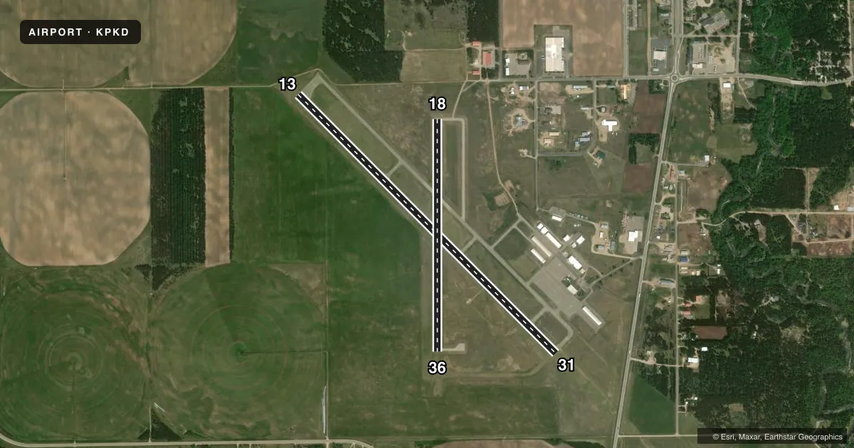
Runways & pattern
Full pagePattern entry · RWY 31
LEFT TRAFFIC| Runway | Heading (°M) | Length | Surface | Traffic |
|---|---|---|---|---|
| 13/31Favored | 131° / 311° | 5,497 ft | ASPH | Standard L |
| 18/36 | 176° / 356° | 3,500 ft | ASPH | Standard L |
Runway end performance
| End | TORA | TODA | ASDA | LDA | VGSI | Approach lights | Obstruction |
|---|---|---|---|---|---|---|---|
| 13 | — | — | — | — | PAPI 4-box left(3°) | — | — |
| 31 | — | — | — | — | PAPI 4-box left(3°) | MALSR | — |
| 18 | — | — | — | — | PAPI 4-box left(3°) | — | — |
| 36 | — | — | — | — | PAPI 4-box right(3°) | — | — |
Declared distances in feet. TORA = takeoff run available, TODA = takeoff distance, ASDA = accelerate-stop, LDA = landing distance.
Airport sketch
Runways drawn to scale from FAA survey coordinates, rendered over satellite imagery. Not for navigation.
Approaches & charts
ILS · 1
Services on the field
Fuel grades, oxygen, maintenance, ramp storage and lighting — as declared to the FAA by the airport operator.
Fuel & services
- Fuel
- 100LL
- Oxygen (bottled)
- Not available
- Oxygen (bulk)
- Not available
- Airframe repair
- Major
- Power plant repair
- Major
- Other services
- AVNCS,RNTL,SALES
Ramp & ground
- Transient storage
- Tie-down
- Hangar
- Landing fee
- No fee published
- Customs
- Not available
- Lighting schedule
- SEE RMK
- Beacon schedule
- SS-SR
- Beacon
- White / Green (civil land)(WG)
- Wind indicator
- Lighted
- Segmented circle
- Yes
Fuel & FBOs
Cheapest 100LL and Jet A on the field and nearby. Always confirm with the FBO before taxi.
Airport notes
Surface conditions, obstructions, local procedures, lighting outages and other notes published with each FAA cycle.
Lighting notes
- ACTVT OR INCR INTST MALSR RWY 31; REIL RWY 13, 18, & 36; PAPI RWY 13, 31, 18, & 36; HIRL RWY 13/31; MIRL RWY 18/36 - CTAF. HIRL RWY 13/31 PRESET LOW INTST SS-SR.
Fuel notes
- 100LL100LL AVBL H24 VIA CREDIT CARD.
Other notes
- 1FOR SVC AFT HRS CALL 218-237-8528.
VFR map & nearby airports
VFR sectional. Tap any ICAO chip to open that airport.
Key facts · KPKD
Answer card- ICAO
- KPKD
- Name
- PARK RAPIDS MUNI/KONSHOK FLD
- Location
- PARK RAPIDS, MINNESOTA
- Elevation
- 1,444.5 ft MSL
- Traffic pattern altitude
- 2,444.5 ft MSL (1,000 AGL)
- Control tower
- Non-towered (use CTAF)
- Total runways
- 2
- Longest runway
- 13/31 · 5,497 ft
- Published ILS approaches
- 1
- Published frequencies
- 2
- Magnetic variation
- 4°
- Current flight rules
- VFR
- Current wind
- 330° at 8 kt
- Favored runway now
- RWY 31
Park Rapids Muni/Konshok Fld sits in Park Rapids, Minnesota. Field elevation is 1,444.5 ft MSL. The airport has two asphalt runways. The longest is runway 13/31 at 5,497 ft. Runway 18/36 is 3,500 ft. There is no control tower. Expect CTAF traffic and self-announce work. CTAF and UNICOM are both 123.0.
The published pattern altitude is not listed. Use the standard 1,000 ft AGL pattern unless local procedures or the current FAA Chart Supplement say otherwise. Runway 31 has the ILS approach. That makes the westbound end the one to check if you need an instrument arrival. The field also has good lighting support. Runway 13/31 has HIRL. Runway 18/36 has MIRL. PAPI is published on both ends of both runways. REIL is available on 13, 18 and 36. MALSR is available on runway 31.
Park Rapids Aviation is on the field. It carries 100LL and Jet A. 100LL is available 24 hours a day by credit card. For after-hours service, call the FBO directly. At this elevation, winter performance and density altitude planning still matter. The airport is in uncontrolled airspace traffic flow. Listen early and build a clean picture before joining the pattern.