METAR & TAF D61
D61 does not publish a METAR.
Showing the nearest reporting station: KRUG (RUGBY MUNI) · 14.9 NM away. Conditions at D61 may differ.
METAR · KRUG
Observed 13:35Z
KRUG 271335Z AUTO 29006KT 4SM BR CLR 19/19 A2988 RMK AO2
- Wind
- 290° @ 6 kt
- Visibility
- 4 SM
- Temp / Dew
- 19°C / 19°C
- Altimeter
- 29.88 inHg
- Clouds
- CLR
- Density alt
- 2,370 ft
- Ceiling
- Unlimited
- Rules
- MVFR
Airport info & contacts
Manager on record, flight service, ARTCC, attendance schedule and pattern altitude — published by the FAA and refreshed every 28 days.
Location
- From city
- 1 NM NE
- VFR sectional
- TWIN CITIES
- ARTCC
- ZMP · MINNEAPOLIS
- NOTAM facility
- GFK (NOTAM-D)
Airport manager
- Name
- DANIEL GUNTER
- Phone
- 701-537-3519
- Address
- PO BOX 330, TOWNER ND 58788
Flight service · Hours
- FSS GFK
- GRAND FORKS1-800-WX-BRIEF
- Attendance
- Unattended
Frequencies
Tap any row to copy the frequency to your clipboard.
Runways & pattern
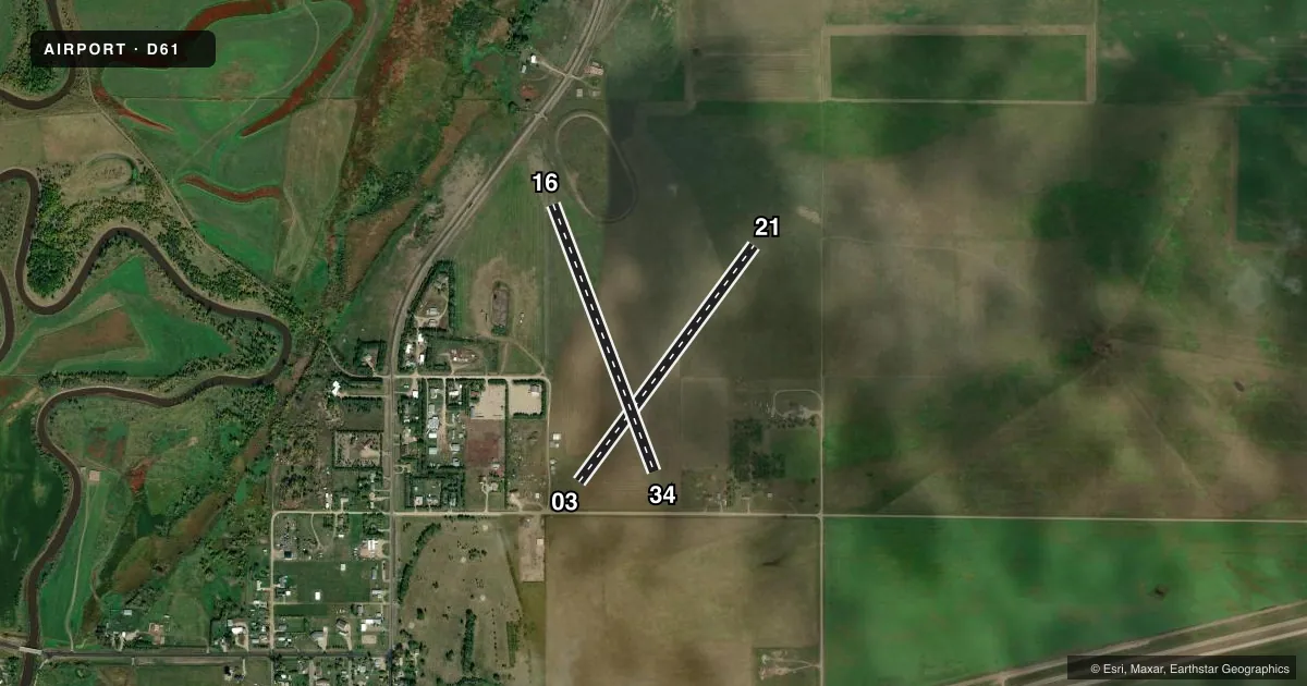
Full pagePattern entry · RWY 34
LEFT TRAFFIC| Runway | Heading (°M) | Length | Surface | Traffic |
|---|---|---|---|---|
| 03/21 | 27° / 207° | 2,810 ft | TURF | Standard L |
| 16/34Favored | 150° / 330° | 2,732 ft | TURF | Standard L |
Runway end performance
| End | TORA | TODA | ASDA | LDA | VGSI | Approach lights | Obstruction |
|---|---|---|---|---|---|---|---|
| 03 | — | — | — | — | — | — | 17', road, 55' from thr, 75' R of cntrln, slope 3 |
| 16 | — | — | — | — | — | — | 17', road, 400' from thr, 250' R of cntrln, slope 23 |
| 34 | — | — | — | — | — | — | 17', road, 175' from thr, 125' R of cntrln, slope 10 |
Declared distances in feet. TORA = takeoff run available, TODA = takeoff distance, ASDA = accelerate-stop, LDA = landing distance.
Airport sketch
Runways drawn to scale from FAA survey coordinates, rendered over satellite imagery. Not for navigation.
Approaches & charts
Services on the field
Fuel grades, oxygen, maintenance, ramp storage and lighting — as declared to the FAA by the airport operator.
Fuel & services
- Fuel
- Not available
- Airframe repair
- Not available
- Power plant repair
- Not available
Ramp & ground
- Transient storage
- Tie-down
- Hangar
- Landing fee
- No fee published
- Lighting schedule
- SEE RMK
- Beacon schedule
- SS-SR
- Beacon
- White / Green (civil land)(WG)
- Wind indicator
- Lighted
- Segmented circle
- No
Fuel & FBOs
Cheapest 100LL and Jet A on the field and nearby. Always confirm with the FBO before taxi.
Airport notes
Surface conditions, obstructions, local procedures, lighting outages and other notes published with each FAA cycle.
General notes
- 3' DITCH SE END OF RWY 16/34 & SW END OF RWY 03/21.
- RWY 16/34 HAS 50' STOPWAY NW END & 130' STOPWAY SE END.
- CFM WINTER COND AFTER SNOWSTORM WITH AMGR 701-537-5137 OR 701-537-3519.
- RY 03 HAS 140 FT WATER TOWER 2000 FT FM THLD 600 FT L OF EXTDD CNTRLN.
- FOR CD CTC MINNEAPOLIS ARTCC AT 651-463-5588.
Lighting notes
- DUSK-DAWN. ACTVT LIRL RWY 16/34 - CTAF.
Runway surface & condition
- 03/21HAS 5 FT RWY VIS SIGHT CLNC VIOLATION.
Approach & departure obstructions
- 0303/21 MKD 3 FT WOODEN RED MKRS ON ENDS & INTXN.
- 1616/34 MKD 3 FT WOODEN RED MKRS ON ENDS & INTXN.
- 0325 FT BLDG 350 FT FM THR 50 FT R OF EXTDD CNTRLN; APCH RATIO 14:1
- 34+30' PLINE 1100 FT FM THR ON CNTRLN, APCH RATIO 36:1.
Other notes
- MANAGERADNL CTC MONTE HERMANSON 701-537-5849.
VFR map & nearby airports
VFR sectional. Tap any ICAO chip to open that airport.
Key facts · D61
Answer card- ICAO
- D61
- Name
- TOWNER MUNI
- Location
- TOWNER, NORTH DAKOTA
- Elevation
- 1,484 ft MSL
- Traffic pattern altitude
- 2,484 ft MSL (1,000 AGL)
- Control tower
- Non-towered (use CTAF)
- Total runways
- 2
- Longest runway
- 03/21 · 2,810 ft
- Published ILS approaches
- 0
- Published frequencies
- 2
- Magnetic variation
- 9°
- Current flight rules
- MVFR
- Current wind
- 290° at 6 kt
- Favored runway now
- RWY 34
Towner Muni is in Towner, North Dakota. The field elevation is 1,484 ft MSL. It has two turf runways. The longest is runway 03/21 at 2,810 ft. There is no control tower. CTAF and UNICOM are both 122.8. No ILS approaches are published.
Pattern altitude is not published. Use the standard 1,000 ft AGL pattern unless the current Chart Supplement says otherwise. That puts the pattern at about 2,484 ft MSL based on the field elevation, but verify before you fly.
There are no on-field FBOs listed. Plan on self-sufficiency. The published remarks matter here. Runway 16/34 has stopways at both ends. There is a ditch near the southeast end of runway 16/34. There is also a ditch near the southwest end of runway 03/21. Runway 03 has a building and a water tower on the approach side. Runway 34 has a power line on centerline in the approach path. Runway 03/21 also has a runway visual sight clearance violation. Winter conditions can change the field fast after a snowstorm, so call the airport manager before arrival if the surface may be covered.