METAR & TAF D50
Current METAR
Observed 03:35Z
KD50 260335Z AUTO 15005KT 8SM FEW050 20/17 A2979 RMK AO2
- Wind
- 150° @ 5 kt
- Visibility
- 8 SM
- Temp / Dew
- 20°C / 17°C
- Altimeter
- 29.79 inHg
- Clouds
- FEW
- Density alt
- 3,183 ft
- Ceiling
- Unlimited
- Rules
- VFR
Airport info & contacts
Manager on record, flight service, ARTCC, attendance schedule and pattern altitude — published by the FAA and refreshed every 28 days.
Location
- From city
- 1 NM N
- VFR sectional
- BILLINGS
- ARTCC
- ZLC · SALT LAKE CITY
- NOTAM facility
- GFK (NOTAM-D)
Airport manager
- Name
- MIKE MELBY
- Phone
- 701-570-0944
- Address
- PO BOX 154, CROSBY ND 58730
Flight service · Hours
- FSS GFK
- GRAND FORKS1-800-WX-BRIEF
- Attendance
- Unattended
Frequencies
Tap any row to copy the frequency to your clipboard.
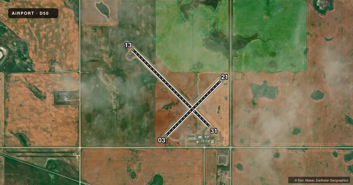
Runways & pattern
Full pagePattern entry · RWY 13
LEFT TRAFFIC| Runway | Heading (°M) | Length | Surface | Traffic |
|---|---|---|---|---|
| 13/31Favored | 127° / 307° | 3,800 ft | ASPH | Standard L |
| 03/21 | 38° / 218° | 2,680 ft | TURF | Standard L |
Runway end performance
| End | TORA | TODA | ASDA | LDA | VGSI | Approach lights | Obstruction |
|---|---|---|---|---|---|---|---|
| 13 | — | — | — | — | PAPI 2-box left(3°) | — | — |
| 31 | — | — | — | — | PAPI 2-box left(3°) | — | — |
Declared distances in feet. TORA = takeoff run available, TODA = takeoff distance, ASDA = accelerate-stop, LDA = landing distance.
Airport sketch
Runways drawn to scale from FAA survey coordinates, rendered over satellite imagery. Not for navigation.
Approaches & charts
Services on the field
Fuel grades, oxygen, maintenance, ramp storage and lighting — as declared to the FAA by the airport operator.
Fuel & services
- Fuel
- 100LL
- Oxygen (bottled)
- Not available
- Oxygen (bulk)
- Not available
- Airframe repair
- Not available
- Power plant repair
- Not available
- Other services
- AGRI
Ramp & ground
- Transient storage
- Tie-down
- Landing fee
- No fee published
- Customs
- Not available
- Lighting schedule
- SEE RMK
- Beacon schedule
- SS-SR
- Beacon
- White / Green (civil land)(WG)
- Wind indicator
- Lighted
- Segmented circle
- Yes
Fuel & FBOs
Cheapest 100LL and Jet A on the field and nearby. Always confirm with the FBO before taxi.
Airport notes
Surface conditions, obstructions, local procedures, lighting outages and other notes published with each FAA cycle.
General notes
- +250' TOWER 4000' SOUTH OF ARPT.
- DEER AND BIRDS ON & INVOF ARPT.
- FOR CD CTC SALT LAKE ARTCC AT 801-320-2568.
Lighting notes
- PAPI RWY 13 & 31 OPER DUSK-0100. MIRL RWY 13/31 PRESET ON LOW INTST DUSK-0100; TO INCR INTST ACTVT - CTAF. AFT 0100 ACTVT MIRL RWY 13/31; PAPI RWY 13 & 31 - CTAF.
Fuel notes
- 100LLSELF SVC FUEL AVBL H24 VIA CREDIT CARD.
Runway surface & condition
- 03/21CLSD WINTER MONTHS DUE TO LACK OF SNOW REMOVAL.
Approach & departure obstructions
- 13PLINE 33 FT ABV RWY END, 2,100 FT FM THLD, 395 FT L & R OF CNTRLN.
Other notes
- MANAGERARPT MAINT & SNOW RMVL CTC PERSON.
- MANAGERHOME PHONE 701-965-4284; ADNL CTC NEIL BENTER 701-641-8554, 701-965-6512, OR 701-965-6775.
- AGRIFOR AGRI SVCS CTC 701-965-4284/6146 OR 701-570-0944.
VFR map & nearby airports
VFR sectional. Tap any ICAO chip to open that airport.
Key facts · D50
Answer card- ICAO
- D50
- Name
- CROSBY MUNI
- Location
- CROSBY, NORTH DAKOTA
- Elevation
- 1,952.7 ft MSL
- Traffic pattern altitude
- 2,952.7 ft MSL (1,000 AGL)
- Control tower
- Non-towered (use CTAF)
- Total runways
- 2
- Longest runway
- 13/31 · 3,800 ft
- Published ILS approaches
- 0
- Published frequencies
- 1
- Magnetic variation
- 7°
- Current flight rules
- VFR
- Current wind
- 150° at 5 kt
- Favored runway now
- RWY 13
Crosby Muni sits in Crosby, North Dakota. The field elevation is 1,952.7 ft MSL. It has two runways. The longest is runway 13/31 at 3,800 ft, with an asphalt surface. Runway 03/21 is 2,680 ft of turf. There is no control tower. CTAF is 122.9.
No ILS approaches are published here. The traffic pattern altitude is not published, so use the standard 1,000 ft AGL for light piston operations unless the current FAA Chart Supplement says otherwise. The on-field FBO is Crosby Municipal Airport. It carries 100LL. Self-service fuel is available 24 hours a day by credit card.
Runway 13/31 has PAPI and medium intensity runway lights. The lighting is preset low from dusk to 0100. Use CTAF to increase intensity. After 0100, activate the runway lights and PAPI on CTAF. Watch for deer and birds on and near the airport. There is also a 250-foot tower about 4,000 ft south of the field. Runway 03/21 is closed during winter months because snow removal is not provided. For clearance delivery, contact Salt Lake ARTCC. Check the current FAA Chart Supplement before flying in for any updates on local procedures or seasonal field status.