METAR & TAF D49
D49 does not publish a METAR.
Showing the nearest reporting station: KXWA (WILLISTON BASIN INTL) · 54.1 NM away. Conditions at D49 may differ.
METAR · KXWA
Observed 07:51Z
KXWA 270751Z AUTO 03007KT 10SM CLR 20/15 A2990 RMK AO2 SLP112 T02000150
- Wind
- 030° @ 7 kt
- Visibility
- 10 SM
- Temp / Dew
- 20°C / 15°C
- Altimeter
- 29.90 inHg
- Clouds
- CLR
- Density alt
- 3,019 ft
- Ceiling
- Unlimited
- Rules
- VFR
Airport info & contacts
Manager on record, flight service, ARTCC, attendance schedule and pattern altitude — published by the FAA and refreshed every 28 days.
Location
- From city
- 1 NM SW
- VFR sectional
- BILLINGS
- ARTCC
- ZMP · MINNEAPOLIS
- NOTAM facility
- GFK (NOTAM-D)
Airport manager
- Name
- RICH CASTELL
- Phone
- (701) 216-0030
- Address
- BOX 42, COLUMBUS ND 58727
Flight service · Hours
- FSS GFK
- GRAND FORKS1-800-WX-BRIEF
- Attendance
- Unattended
Frequencies
Tap any row to copy the frequency to your clipboard.
Runways & pattern
Full pagePattern entry · RWY 07
LEFT TRAFFICRunway end performance
| End | TORA | TODA | ASDA | LDA | VGSI | Approach lights | Obstruction |
|---|---|---|---|---|---|---|---|
| 25 | — | — | — | — | — | — | 17', road, 47' from thr, 0' R of cntrln, slope 2 |
Declared distances in feet. TORA = takeoff run available, TODA = takeoff distance, ASDA = accelerate-stop, LDA = landing distance.
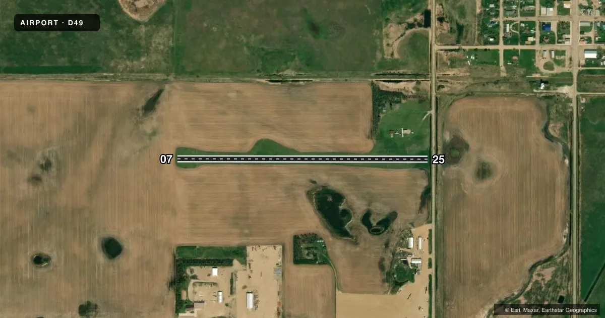
Airport sketch
Runways drawn to scale from FAA survey coordinates, rendered over satellite imagery. Not for navigation.
Approaches & charts
Services on the field
Fuel grades, oxygen, maintenance, ramp storage and lighting — as declared to the FAA by the airport operator.
Fuel & services
- Fuel
- Not available
- Oxygen (bottled)
- Not available
- Oxygen (bulk)
- Not available
- Airframe repair
- Not available
- Power plant repair
- Not available
Ramp & ground
- Transient storage
- Not published
- Landing fee
- No fee published
- Customs
- Not available
- Wind indicator
- Yes
- Segmented circle
- No
Fuel & FBOs
Cheapest 100LL and Jet A on the field and nearby. Always confirm with the FBO before taxi.
Airport notes
Surface conditions, obstructions, local procedures, lighting outages and other notes published with each FAA cycle.
General notes
- NO SNOW REMOVAL AVAILABLE WINTER MONTHS; CFM WINTER CONDS WITH AMGR 701-339-0355, 701-939-5038, OR 701-339-8420.
- RY 25 HAS -5 FT DITCH 30 FT FROM THR.
- WINDSOCK PENETRATES TRSN SFC.
- FOR CD CTC MINNEAPOLIS ARTCC AT 651-463-5588.
Approach & departure obstructions
- 25+13 FT ROAD 451 FT FROM RWY 25 DSPLCD THR; 0 L/R OF CL; APCH SLOPE RATIO 34:1.
Other notes
- OWNERKEITH BERG - CLERK FOR APT AUTH
- MANAGERADNL CTC PHONE 701-939-5038 OR KEITH BERG 701-339-8420.
VFR map & nearby airports
VFR sectional. Tap any ICAO chip to open that airport.
Key facts · D49
Answer card- ICAO
- D49
- Name
- COLUMBUS MUNI
- Location
- COLUMBUS, NORTH DAKOTA
- Elevation
- 1,931 ft MSL
- Traffic pattern altitude
- 2,931 ft MSL (1,000 AGL)
- Control tower
- Non-towered (use CTAF)
- Total runways
- 1
- Longest runway
- 07/25 · 2,560 ft
- Published ILS approaches
- 0
- Published frequencies
- 1
- Magnetic variation
- 12°
- Current flight rules
- VFR
- Current wind
- 030° at 7 kt
- Favored runway now
- RWY 07
Columbus Muni sits in Columbus, North Dakota. Field elevation is 1,931 ft MSL. The airport has one runway. Runway 07/25 is 2,560 ft of turf, so performance planning matters if you are bringing a heavier airplane or operating on a soft surface. No tower is published here. CTAF is 122.9.
No ILS approaches are published. Pattern altitude is not published in the facts, so use the standard 1,000 ft AGL for light piston operations unless the current Chart Supplement says otherwise. The field has no on-field FBOs listed. Plan on self-sufficiency and confirm services before you go. Published remarks point to winter limitations. No snow removal is available during winter months, so check conditions with the airport manager before arrival. The remarks also note an obstacle issue near runway 25. There is a road near the displaced threshold. There is also a ditch close to the threshold. That makes a careful look at runway condition and landing distance important before you commit. This is a non-towered field with no published ILS, so VFR arrivals should be ready to self-announce clearly and keep an eye on turf condition, winds and density altitude.