METAR & TAF Y27
Y27 does not publish a METAR.
Showing the nearest reporting station: KMBG (MOBRIDGE MUNI) · 32.7 NM away. Conditions at Y27 may differ.
METAR · KMBG
Observed 11:52Z
KMBG 271152Z AUTO 36007KT 4SM HZ CLR 18/15 A2987 RMK AO2 SLP099 T01780150 10244 20156 53012
- Wind
- 360° @ 7 kt
- Visibility
- 4 SM
- Temp / Dew
- 18°C / 15°C
- Altimeter
- 29.87 inHg
- Clouds
- CLR
- Density alt
- 2,448 ft
- Ceiling
- Unlimited
- Rules
- MVFR
Airport info & contacts
Manager on record, flight service, ARTCC, attendance schedule and pattern altitude — published by the FAA and refreshed every 28 days.
Location
- From city
- 1 NM S
- VFR sectional
- TWIN CITIES
- ARTCC
- ZMP · MINNEAPOLIS
- NOTAM facility
- GFK (NOTAM-D)
Airport manager
- Name
- LARISSA YOUNG
- Phone
- 701-301-7463
- Address
- PO BOX D, FORT YATES ND 58538
Flight service · Hours
- FSS GFK
- GRAND FORKS1-800-WX-BRIEF
- Attendance
- Unattended
Frequencies
Tap any row to copy the frequency to your clipboard.
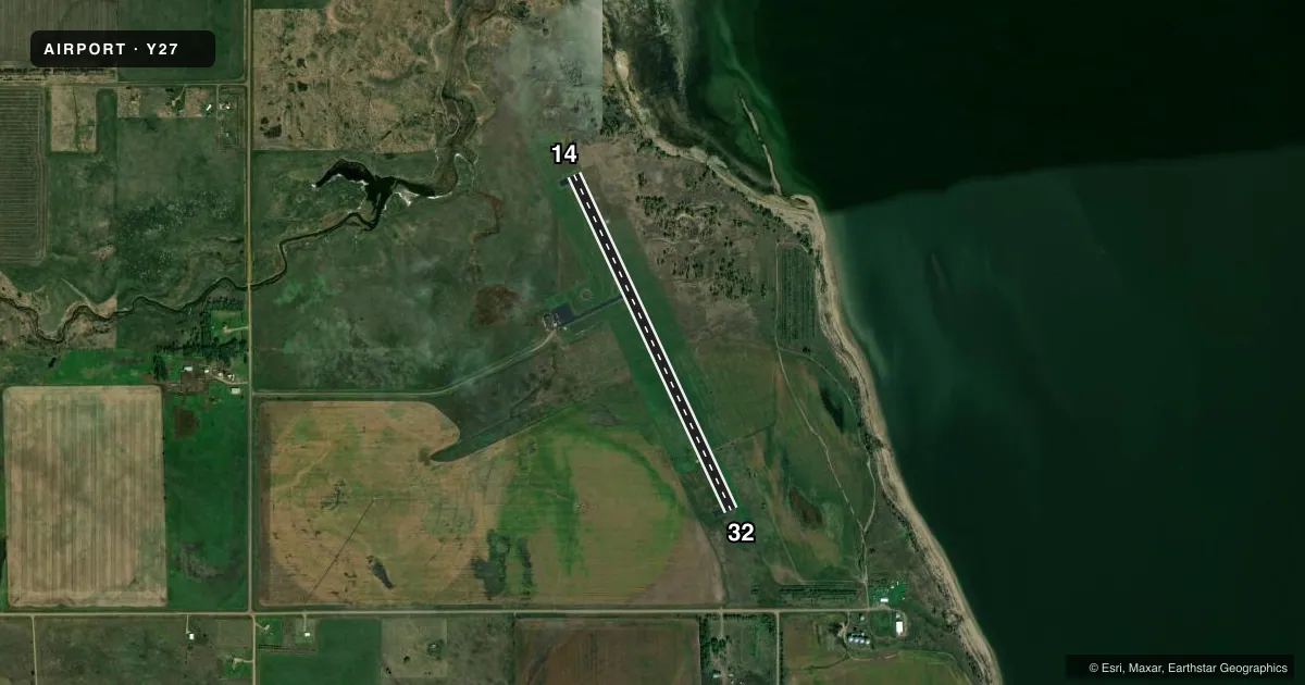
Runways & pattern
Full pagePattern entry · RWY 32
LEFT TRAFFICRunway end performance
| End | TORA | TODA | ASDA | LDA | VGSI | Approach lights | Obstruction |
|---|---|---|---|---|---|---|---|
| 14 | 3,699' | 3,699' | 3,699' | 3,699' | PAPI 2-box left(3°) | — | — |
| 32 | 3,699' | 3,699' | 3,699' | 3,699' | PAPI 2-box left(3°) | — | 15', fence, 440' from thr, 150' R of cntrln, slope 16 |
Declared distances in feet. TORA = takeoff run available, TODA = takeoff distance, ASDA = accelerate-stop, LDA = landing distance.
Airport sketch
Runways drawn to scale from FAA survey coordinates, rendered over satellite imagery. Not for navigation.
Approaches & charts
Services on the field
Fuel grades, oxygen, maintenance, ramp storage and lighting — as declared to the FAA by the airport operator.
Fuel & services
- Fuel
- Not available
- Oxygen (bottled)
- Not available
- Oxygen (bulk)
- Not available
- Airframe repair
- Not available
- Power plant repair
- Not available
Ramp & ground
- Transient storage
- Tie-down
- Landing fee
- No fee published
- Customs
- Not available
- Lighting schedule
- SEE RMK
- Beacon schedule
- SEE RMK
- Beacon
- White / Green (civil land)(WG)
- Wind indicator
- Lighted
- Segmented circle
- Yes
Fuel & FBOs
Cheapest 100LL and Jet A on the field and nearby. Always confirm with the FBO before taxi.
Airport notes
Surface conditions, obstructions, local procedures, lighting outages and other notes published with each FAA cycle.
General notes
- CFM SNOW REMOVAL OCT-APR; CALL 701-854-8611; 701-455-1811; 701-854-8622.
- BIRDS AND WATERFOWL ON AND INVOF ARPT.
- FOR CD CTC MINNEAPOLIS ARTCC AT 651-463-5588.
- GATE CODE PROTECTED - LOCAL ZIP CODE.
Lighting notes
- APT BCN OPR CONSLY DUSK-2400; AFT 2400 ACTVT - CTAF.
- ACTVT PAPI RWY 14 & 32 - CTAF. MIRL RWY 14/32 OPR CONSLY DUSK-0000; AFT 0000 ACTVT - CTAF.
Other notes
- MANAGERADDNL PHONE 701-854-8500 EXT 7002, STANDING ROCK ADMIN OFFICE
VFR map & nearby airports
VFR sectional. Tap any ICAO chip to open that airport.
Key facts · Y27
Answer card- ICAO
- Y27
- Name
- STANDING ROCK
- Location
- FORT YATES, NORTH DAKOTA
- Elevation
- 1,633.7 ft MSL
- Traffic pattern altitude
- 2,633.7 ft MSL (1,000 AGL)
- Control tower
- Non-towered (use CTAF)
- Total runways
- 1
- Longest runway
- 14/32 · 3,699 ft
- Published ILS approaches
- 0
- Published frequencies
- 1
- Magnetic variation
- 9°
- Current flight rules
- MVFR
- Current wind
- 360° at 7 kt
- Favored runway now
- RWY 32
Standing Rock Airport sits in Fort Yates, North Dakota. The field elevation is 1,633.7 ft MSL. It has one runway, 14/32, which is 3,699 ft long with asphalt surface. There is no control tower. CTAF is 122.9.
No ILS approaches are published here. The pattern altitude is not published in the facts, so use the standard 1,000 ft AGL for light piston operations unless the current FAA Chart Supplement says otherwise. Runway 14 and 32 have PAPI. The medium intensity runway lights run continuously from dusk to midnight. After midnight, they are activated by CTAF. The airport beacon follows the same schedule.
There are no on-field FBOs listed. Plan on confirming services directly before arrival. Clearance delivery is handled through Minneapolis ARTCC. Snow removal should be confirmed from October through April. Birds and waterfowl are reported on and near the airport, so keep a sharp scan on departure and arrival. The gate code is protected and uses the local zip code. For a first visit, the main things to brief are the single runway layout, the lighting activation after midnight and the wildlife activity around the field.