METAR & TAF 5T4
5T4 does not publish a METAR.
Showing the nearest reporting station: KMBG (MOBRIDGE MUNI) · 22.9 NM away. Conditions at 5T4 may differ.
METAR · KMBG
Observed 14:52Z
KMBG 271452Z AUTO 04008KT 8SM CLR 27/17 A2988 RMK AO2 SLP102 T02670167 50003
- Wind
- 040° @ 8 kt
- Visibility
- 8 SM
- Temp / Dew
- 27°C / 17°C
- Altimeter
- 29.88 inHg
- Clouds
- CLR
- Density alt
- 3,629 ft
- Ceiling
- Unlimited
- Rules
- VFR
Airport info & contacts
Manager on record, flight service, ARTCC, attendance schedule and pattern altitude — published by the FAA and refreshed every 28 days.
Location
- From city
- 1 NM N
- VFR sectional
- TWIN CITIES
- ARTCC
- ZMP · MINNEAPOLIS
- NOTAM facility
- HON (NOTAM-D)
Airport manager
- Name
- BRETT VAN VUGT
- Phone
- (605) 437-2302
- Address
- PO BOX 676, PO BOX 767, HERREID SD 57632
Flight service · Hours
- FSS HON
- HURON1-800-WX-BRIEF
- Attendance
- Unattended
Frequencies
Tap any row to copy the frequency to your clipboard.
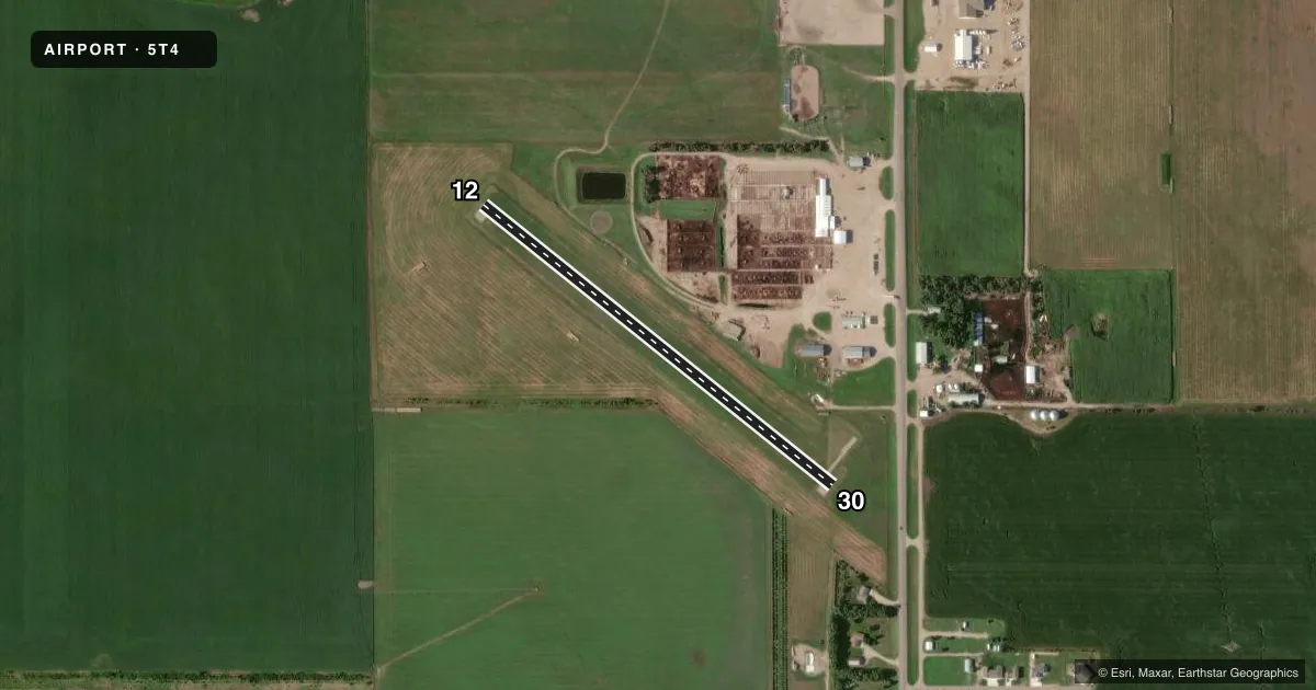
Runways & pattern
Full pagePattern entry · RWY 12
LEFT TRAFFICRunway end performance
| End | TORA | TODA | ASDA | LDA | VGSI | Approach lights | Obstruction |
|---|---|---|---|---|---|---|---|
| 30 | — | — | — | — | — | — | 15', road, 314' from thr, 0' R of cntrln, slope 20 |
Declared distances in feet. TORA = takeoff run available, TODA = takeoff distance, ASDA = accelerate-stop, LDA = landing distance.
Airport sketch
Runways drawn to scale from FAA survey coordinates, rendered over satellite imagery. Not for navigation.
Approaches & charts
Services on the field
Fuel grades, oxygen, maintenance, ramp storage and lighting — as declared to the FAA by the airport operator.
Fuel & services
- Fuel
- Not available
- Oxygen (bottled)
- Not available
- Oxygen (bulk)
- Not available
- Airframe repair
- Not available
- Power plant repair
- Not available
- Other services
- AGRI
Ramp & ground
- Transient storage
- Tie-down
- Landing fee
- No fee published
- Customs
- Not available
- Wind indicator
- Yes
- Segmented circle
- Yes
Fuel & FBOs
Cheapest 100LL and Jet A on the field and nearby. Always confirm with the FBO before taxi.
Airport notes
Surface conditions, obstructions, local procedures, lighting outages and other notes published with each FAA cycle.
General notes
- RY 12 CULTIVATION 80' FM THR.
- WILDLIFE ON AND INVOF ARPT.
- FOR CD CTC MINNEAPOLIS ARTCC AT 651-463-5588.
Approach & departure obstructions
- 12MKD WITH WHITE & BLACK TIPPED MKR CONES.
- 30MKD WITH WHITE & BLACK TIPPED MKR CONES.
Other notes
- PRIOR TO 1959.
- 12/30CENTER 30' OF ASPHALT IN POOR CONDITION.
- 12/30CNTR 30 FT OF RY IS ASPH.
VFR map & nearby airports
VFR sectional. Tap any ICAO chip to open that airport.
Key facts · 5T4
Answer card- ICAO
- 5T4
- Name
- HERREID MUNI
- Location
- HERREID, SOUTH DAKOTA
- Elevation
- 1,725 ft MSL
- Traffic pattern altitude
- 2,725 ft MSL (1,000 AGL)
- Control tower
- Non-towered (use CTAF)
- Total runways
- 1
- Longest runway
- 12/30 · 2,230 ft
- Published ILS approaches
- 0
- Published frequencies
- 1
- Magnetic variation
- 9°
- Current flight rules
- VFR
- Current wind
- 040° at 8 kt
- Favored runway now
- RWY 12
Herreid Muni sits in Herreid, South Dakota. The field elevation is 1,725 ft MSL. It has one runway. Runway 12/30 is 2,230 ft long with an asphalt-turf surface. The center 30 ft is asphalt. The published remarks say that asphalt section is in poor condition. Runway 12 is marked with white and black tipped marker cones. Runway 30 is marked the same way.
There is no control tower. CTAF is 122.9. No ILS approaches are published here, so plan with the current charting and weather in mind. The pattern altitude is not published. Use the standard 1,000 ft AGL pattern unless the current Chart Supplement tells you otherwise. That puts the light piston pattern at about 2,725 ft MSL.
No on-field FBOs are listed, so verify fuel and services with the airport operator or by calling the field before you go. The published remarks also note cultivation 80 ft from the Runway 12 threshold. Wildlife is reported on and near the airport. For clearance delivery, contact Minneapolis ARTCC at 651-463-5588. This is a small non-towered field. Give yourself time to inspect the runway condition. Watch the cones. Stay alert for animals and field activity.