METAR & TAF KMBG
Current METAR
Observed 15:52Z
KMBG 271552Z AUTO 04007KT 10SM CLR 29/17 A2988 RMK AO2 SLP100 T02890167
- Wind
- 040° @ 7 kt
- Visibility
- 10 SM
- Temp / Dew
- 29°C / 17°C
- Altimeter
- 29.88 inHg
- Clouds
- CLR
- Density alt
- 3,858 ft
- Ceiling
- Unlimited
- Rules
- VFR
Airport info & contacts
Manager on record, flight service, ARTCC, attendance schedule and pattern altitude — published by the FAA and refreshed every 28 days.
Location
- From city
- 1 NM NE
- VFR sectional
- TWIN CITIES
- ARTCC
- ZMP · MINNEAPOLIS
- NOTAM facility
- MBG (NOTAM-D)
Airport manager
- Name
- BRADY FUHRER
- Phone
- 605-850-9935
- Address
- 114 1ST AVENUE E, MOBRIDGE SD 57601
Flight service · Hours
- FSS HON
- HURON1-800-WX-BRIEF
- Attendance
- MON-FRI · 0900-1800
- SAT · ON CALL 0900-1800 FBO CLSD SUN
Frequencies
Tap any row to copy the frequency to your clipboard.
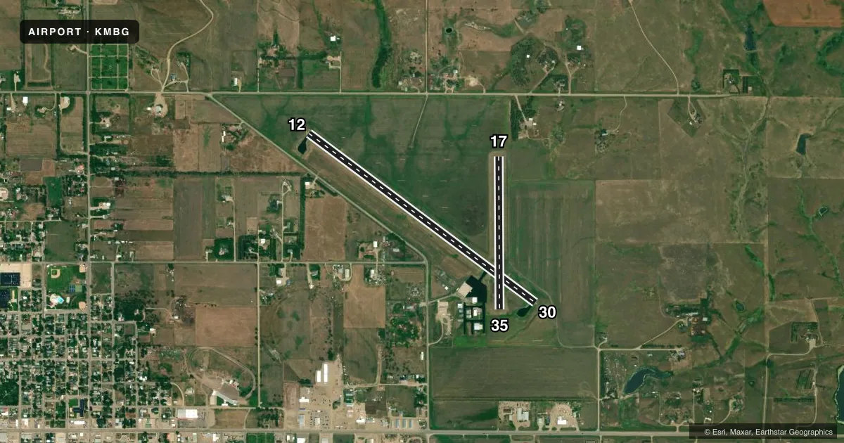
Runways & pattern
Full pagePattern entry · RWY 35
LEFT TRAFFIC| Runway | Heading (°M) | Length | Surface | Traffic |
|---|---|---|---|---|
| 12/30 | 118° / 298° | 4,410 ft | ASPH | Standard L |
| 17/35Favored | 171° / 351° | 2,387 ft | TURF | Standard L |
Runway end performance
| End | TORA | TODA | ASDA | LDA | VGSI | Approach lights | Obstruction |
|---|---|---|---|---|---|---|---|
| 12 | — | — | — | — | PAPI 2-box left(3°) | — | 52', tree, 1205' from thr, 287' R of cntrln, slope 19 |
| 30 | — | — | — | — | PAPI 2-box right(3°) | — | — |
| 17 | — | — | — | — | — | — | 43', road, 882' from thr, 0' R of cntrln, slope 20 |
Declared distances in feet. TORA = takeoff run available, TODA = takeoff distance, ASDA = accelerate-stop, LDA = landing distance.
Airport sketch
Runways drawn to scale from FAA survey coordinates, rendered over satellite imagery. Not for navigation.
Approaches & charts
Services on the field
Fuel grades, oxygen, maintenance, ramp storage and lighting — as declared to the FAA by the airport operator.
Fuel & services
- Fuel
- 100LLAMOGAS
- Oxygen (bottled)
- Not available
- Oxygen (bulk)
- Not available
- Airframe repair
- Minor
- Power plant repair
- Minor
- Other services
- AFRT,AGRI,INSTR
Ramp & ground
- Transient storage
- Tie-down
- Hangar
- Landing fee
- No fee published
- Customs
- Not available
- Lighting schedule
- SEE RMK
- Beacon schedule
- SS-SR
- Beacon
- White / Green (civil land)(WG)
- Wind indicator
- Lighted
- Segmented circle
- No
Fuel & FBOs
Cheapest 100LL and Jet A on the field and nearby. Always confirm with the FBO before taxi.
Airport notes
Surface conditions, obstructions, local procedures, lighting outages and other notes published with each FAA cycle.
General notes
- WILDLIFE ON AND INVOF ARPT.
- GCO AVBL ON FREQ 121.725 (4 CLICKS TO MINNEAPOLIS CENTER)
- FOR CD IF UNA TO CTC ON FSS FREQ, CTC MINNEAPOLIS ARTCC AT 651-463-5588.
Lighting notes
- ACTVT PAPI RWY 12 & 30; MIRL RWY 12/30 - CTAF.
Runway surface & condition
- 17/35RWY 17/35 CLSD WINTER MONTHS.
Other notes
- 17/35SOME GOPHER HOLES.
VFR map & nearby airports
VFR sectional. Tap any ICAO chip to open that airport.
Key facts · KMBG
Answer card- ICAO
- KMBG
- Name
- MOBRIDGE MUNI
- Location
- MOBRIDGE, SOUTH DAKOTA
- Elevation
- 1,716.1 ft MSL
- Traffic pattern altitude
- 2,716.1 ft MSL (1,000 AGL)
- Control tower
- Non-towered (use CTAF)
- Total runways
- 2
- Longest runway
- 12/30 · 4,410 ft
- Published ILS approaches
- 0
- Published frequencies
- 2
- Magnetic variation
- 9°
- Current flight rules
- VFR
- Current wind
- 040° at 7 kt
- Favored runway now
- RWY 35
Mobridge Muni is in Mobridge, South Dakota. The field elevation is 1,716.1 ft MSL. It has two runways. The longest is 12/30 at 4,410 ft. There is no control tower, so plan on CTAF self-announce work on 122.8.
No ILS approaches are published here. The pattern altitude is not published, so use the current Chart Supplement before you go. The on-field FBO is Mobridge Municipal Airport. It carries 100LL, Jet A and MOGAS. Call ahead at (605) 216-6565 if you need current service details.
A few published remarks matter for preflight planning. Wildlife is reported on and near the airport. Runway 17/35 has gopher holes. That runway is also closed during winter months. Runway 12/30 has PAPI and medium intensity runway lights. If you need clearance delivery and cannot reach Flight Service, Minneapolis Center is the backup contact listed in the Chart Supplement. For a first-time arrival, 12/30 is the runway to focus on. Check the current runway status before departure. Then brief the surface conditions and local traffic on 122.8.