METAR & TAF KGWR
Current METAR
Observed 21:35Z
KGWR 272135Z AUTO 30006KT 9SM CLR 31/22 A2983 RMK A01
- Wind
- 300° @ 6 kt
- Visibility
- 9 SM
- Temp / Dew
- 31°C / 22°C
- Altimeter
- 29.83 inHg
- Clouds
- CLR
- Density alt
- 3,601 ft
- Ceiling
- Unlimited
- Rules
- VFR
Airport info & contacts
Manager on record, flight service, ARTCC, attendance schedule and pattern altitude — published by the FAA and refreshed every 28 days.
Location
- From city
- 1 NM SE
- VFR sectional
- TWIN CITIES
- ARTCC
- ZMP · MINNEAPOLIS
- NOTAM facility
- GFK (NOTAM-D)
Airport manager
- Name
- RICK HOISTAD
- Phone
- 701-680-8000
- Address
- BOX 221, FORMAN ND 58032
Flight service · Hours
- FSS GFK
- GRAND FORKS1-800-WX-BRIEF
- Attendance
- Unattended
Frequencies
Tap any row to copy the frequency to your clipboard.
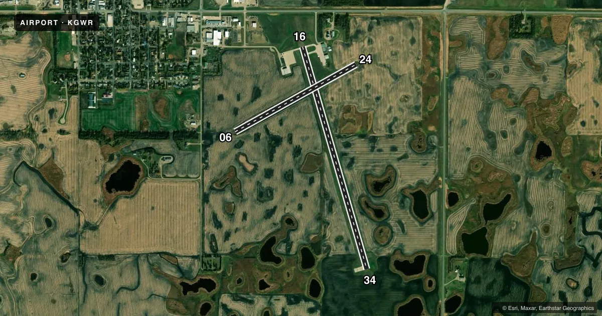
Runways & pattern
Full pagePattern entry · RWY 34
LEFT TRAFFIC| Runway | Heading (°M) | Length | Surface | Traffic |
|---|---|---|---|---|
| 16/34Favored | 160° / 340° | 5,000 ft | CONC | Standard L |
| 06/24 | 57° / 237° | 2,991 ft | TURF | Standard L |
Runway end performance
| End | TORA | TODA | ASDA | LDA | VGSI | Approach lights | Obstruction |
|---|---|---|---|---|---|---|---|
| 16 | — | — | — | — | PAPI 2-box left(3°) | — | — |
| 34 | — | — | — | — | PAPI 2-box left(3°) | — | — |
Declared distances in feet. TORA = takeoff run available, TODA = takeoff distance, ASDA = accelerate-stop, LDA = landing distance.
Airport sketch
Runways drawn to scale from FAA survey coordinates, rendered over satellite imagery. Not for navigation.
Approaches & charts
Services on the field
Fuel grades, oxygen, maintenance, ramp storage and lighting — as declared to the FAA by the airport operator.
Fuel & services
- Fuel
- 100LLA
- Oxygen (bottled)
- Not available
- Oxygen (bulk)
- Not available
- Airframe repair
- Not available
- Power plant repair
- Not available
- Other services
- AGRI,INSTR
Ramp & ground
- Transient storage
- Tie-down
- Hangar
- Landing fee
- No fee published
- Customs
- Not available
- Lighting schedule
- SEE RMK
- Beacon schedule
- SS-SR
- Beacon
- White / Green (civil land)(WG)
- Wind indicator
- Lighted
- Segmented circle
- No
Fuel & FBOs
Cheapest 100LL and Jet A on the field and nearby. Always confirm with the FBO before taxi.
Airport notes
Surface conditions, obstructions, local procedures, lighting outages and other notes published with each FAA cycle.
General notes
- RY 06/24 CLSD WINTER MONTHS.
- CFM WINTER CONDS & RWY 16/34 SN REMOVAL CALL 701-680-8000; 701-308-0169;CITY MAINT 701-680-0081.
- RY 16 +480 FT LGTD TOWER 17500 FT FM THLD 3000 FT R OF EXTDD CNTRLN.
- DEER & BIRDS ON & INVOF ARPT.
- FOR CD CTC MINNEAPOLIS ARTCC AT 651-463-5588.
Lighting notes
- ACTVT REIL RY 16/34; PAPI RY 16/34 AND MIRL RY 16/34 - CTAF.
Fuel notes
- 100LLSELF SERVICE FUEL AVAILABLE 24 HRS WITH CREDIT CARD.
Approach & departure obstructions
- 06RWY 06/24 NO EDGE MKRS.
- 16+42 FT PLINE 2680 FT FM THLD ON CNTRLN APCH RATIO 50:1.
Other notes
- OWNERADDITIONAL CONTACT GROVER RIEBE 701-680-0605
- OWNERAPT AUTHORITY CHRMN RICK HOISTAD
- AGRIFOR AGRI SVC CTC 701-308-0169.
VFR map & nearby airports
VFR sectional. Tap any ICAO chip to open that airport.
Key facts · KGWR
Answer card- ICAO
- KGWR
- Name
- GWINNER/ROGER MELROE FLD
- Location
- GWINNER, NORTH DAKOTA
- Elevation
- 1,265.5 ft MSL
- Traffic pattern altitude
- 2,265.5 ft MSL (1,000 AGL)
- Control tower
- Non-towered (use CTAF)
- Total runways
- 2
- Longest runway
- 16/34 · 5,000 ft
- Published ILS approaches
- 0
- Published frequencies
- 2
- Magnetic variation
- 4°
- Current flight rules
- VFR
- Current wind
- 300° at 6 kt
- Favored runway now
- RWY 34
Gwinner/Roger Melroe Fld (KGWR) sits in Gwinner, North Dakota. Field elevation is 1,265.5 ft MSL. The airport has two runways. The longest is runway 16/34 at 5,000 ft of concrete. Runway 06/24 is 2,991 ft of turf. There is no control tower. CTAF and UNICOM are both 122.7.
No ILS approaches are published here. Pattern altitude is not published, so a light piston pilot should plan on the standard 1,000 ft AGL unless the current Chart Supplement says otherwise. Hoistad Flying Service is on the field. It carries 100LL and Jet A. Self-service 100LL is available 24 hours with credit card. That is useful if you are planning an early arrival or a quick turn.
Winter is the big operational issue here. Runway 06/24 is closed during winter months. Before you go, confirm winter conditions and runway 16/34 snow removal with the airport contacts in the Chart Supplement or by calling the airport directly. The published remarks also note deer and birds in the area. Runway 16 has a lighted tower 17,500 ft from the threshold, 3,000 ft right of the extended centerline. Runway 16/34 also has REIL, PAPI and medium intensity runway lights controlled on CTAF. For clearance delivery, contact Minneapolis ARTCC.