METAR & TAF C25
C25 does not publish a METAR.
Showing the nearest reporting station: KALO (WATERLOO RGNL) · 12.0 NM away. Conditions at C25 may differ.
METAR · KALO
Observed 15:54Z
KALO 271554Z 29009KT 10SM CLR 32/26 A2973 RMK AO2 SLP060 T03170256
- Wind
- 290° @ 9 kt
- Visibility
- 10 SM
- Temp / Dew
- 32°C / 26°C
- Altimeter
- 29.73 inHg
- Clouds
- CLR
- Density alt
- 3,506 ft
- Ceiling
- Unlimited
- Rules
- VFR
Airport info & contacts
Manager on record, flight service, ARTCC, attendance schedule and pattern altitude — published by the FAA and refreshed every 28 days.
Location
- From city
- 2 NM NW
- VFR sectional
- CHICAGO
- ARTCC
- ZMP · MINNEAPOLIS
- NOTAM facility
- FOD (NOTAM-D)
Airport manager
- Name
- IRVIN SWIETER
- Phone
- 319-352-8862
- Address
- 1710 35TH ST NW, WAVERLY IA 50677
Flight service · Hours
- FSS FOD
- FORT DODGE1-800-WX-BRIEF
- Attendance
- MON-SAT · 0800-1700
- SUN · 1200-1700
Frequencies
Tap any row to copy the frequency to your clipboard.
Runways & pattern
Full pagePattern entry · RWY 29
LEFT TRAFFICRunway end performance
| End | TORA | TODA | ASDA | LDA | VGSI | Approach lights | Obstruction |
|---|---|---|---|---|---|---|---|
| 11 | — | — | — | — | PAPI 2-box left(3°) | — | — |
| 29 | — | — | — | — | PAPI 2-box left(3°) | — | — |
Declared distances in feet. TORA = takeoff run available, TODA = takeoff distance, ASDA = accelerate-stop, LDA = landing distance.
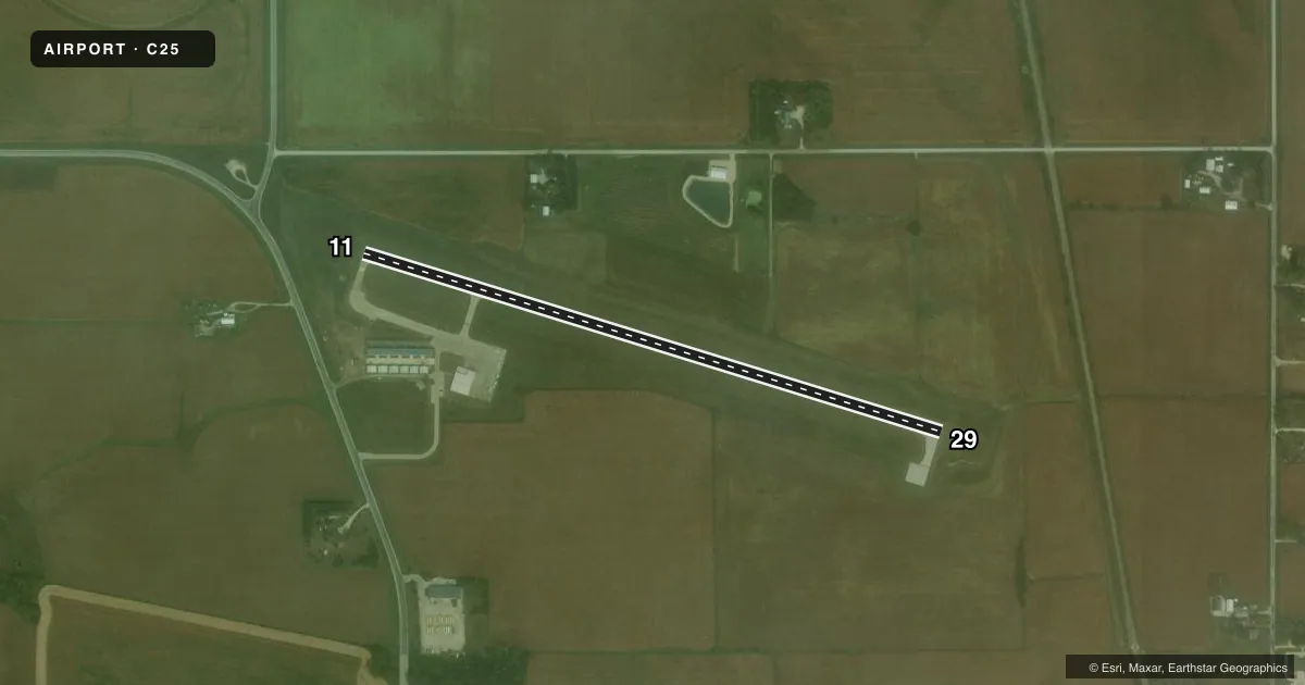
Airport sketch
Runways drawn to scale from FAA survey coordinates, rendered over satellite imagery. Not for navigation.
Approaches & charts
Services on the field
Fuel grades, oxygen, maintenance, ramp storage and lighting — as declared to the FAA by the airport operator.
Fuel & services
- Fuel
- 100LL
- Oxygen (bottled)
- HIGH/LOW
- Oxygen (bulk)
- Not available
- Airframe repair
- Major
- Power plant repair
- Major
- Other services
- INSTR,RNTL
Ramp & ground
- Transient storage
- Tie-down
- Hangar
- Landing fee
- No fee published
- Customs
- Not available
- Lighting schedule
- SEE RMK
- Beacon schedule
- SS-SR
- Beacon
- White / Green (civil land)(WG)
- Wind indicator
- Lighted
- Segmented circle
- No
Fuel & FBOs
Cheapest 100LL and Jet A on the field and nearby. Always confirm with the FBO before taxi.
Airport notes
Surface conditions, obstructions, local procedures, lighting outages and other notes published with each FAA cycle.
General notes
- RY 11 PLINES L & R ON APCH. PLINE R ON APCH MKD WITH BALL MARKERS.
- FOR CD CTC DES MOINES APCH AT 515-974-8016. WHEN DES MOINES APCH CLSD, FOR CD CTC MINNEAPOLIS ARTCC AT 651-463-5588.
Lighting notes
- ACTVT REIL RWY 11 AND 29; PAPI RWY 11 AND 29; MIRL RWY 11/29 - CTAF.
Other notes
- OWNERMIKE CHERRY - PUBLIC WORKS DEPT.
VFR map & nearby airports
VFR sectional. Tap any ICAO chip to open that airport.
Key facts · C25
Answer card- ICAO
- C25
- Name
- WAVERLY MUNI
- Location
- WAVERLY, IOWA
- Elevation
- 992.3 ft MSL
- Traffic pattern altitude
- 1,992.3 ft MSL (1,000 AGL)
- Control tower
- Non-towered (use CTAF)
- Total runways
- 1
- Longest runway
- 11/29 · 3,200 ft
- Published ILS approaches
- 0
- Published frequencies
- 4
- Magnetic variation
- 0°
- Current flight rules
- VFR
- Current wind
- 290° at 9 kt
- Favored runway now
- RWY 29
Waverly Muni sits in Waverly, Iowa at 992.3 ft MSL. It has one runway. Runway 11/29 is 3,200 ft of concrete, so plan performance with that length in mind. The field is non-towered. Pattern altitude is not published, so use the standard 1,000 ft AGL for light piston traffic unless the current Chart Supplement says otherwise.
No ILS approaches are published here. If you are planning an instrument arrival, check the current procedure set before you launch. CTAF and UNICOM are both 122.8. Des Moines Approach handles approach and departure services on 118.9 and 251.15. For clearance delivery, contact Des Moines Approach at 515-974-8016. When Des Moines Approach is closed, Minneapolis ARTCC handles clearance delivery at 651-463-5588.
Two on-field FBOs are listed. Waverly Air Service carries 100LL. Swieter Aircraft Services carries 100LL. Runway 11 has power lines on both sides of the approach path. The right-side line is marked with balls. Runway end identifier lights are on Runways 11 and 29. PAPI is also installed on both ends. Medium intensity runway lights on 11/29 are controlled by CTAF. That makes the field straightforward, but the approach to 11 deserves a careful look, especially if you are arriving at night or in marginal visibility.