METAR & TAF KOLZ
Current METAR
Observed 13:35Z
KOLZ 271335Z AUTO 19006KT 10SM CLR A2977 RMK A01
- Wind
- 190° @ 6 kt
- Visibility
- 10 SM
- Temp / Dew
- —
- Altimeter
- 29.77 inHg
- Clouds
- CLR
- Density alt
- —
- Ceiling
- Unlimited
- Rules
- VFR
Airport info & contacts
Manager on record, flight service, ARTCC, attendance schedule and pattern altitude — published by the FAA and refreshed every 28 days.
Location
- From city
- 3 NM W
- VFR sectional
- CHICAGO
- ARTCC
- ZMP · MINNEAPOLIS
- NOTAM facility
- OLZ (NOTAM-D)
Airport manager
- Name
- DYLAN MULFINGER
- Phone
- (319) 283-5440
- Address
- 20 - 2ND AVENUE SW, OELWEIN IA 50662
Flight service · Hours
- FSS FOD
- FORT DODGE1-800-WX-BRIEF
- Attendance
- Unattended
Frequencies
Tap any row to copy the frequency to your clipboard.
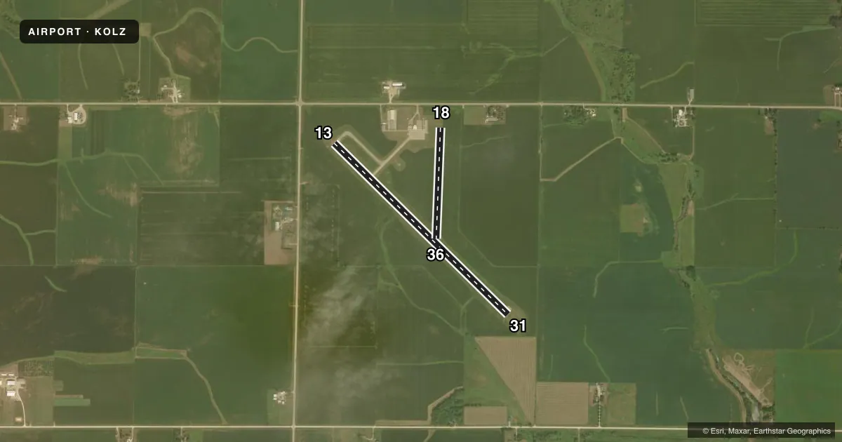
Runways & pattern
Full pagePattern entry · RWY 18
LEFT TRAFFIC| Runway | Heading (°M) | Length | Surface | Traffic |
|---|---|---|---|---|
| 13/31 | 133° / 313° | 4,000 ft | CONC | Standard L |
| 18/36Favored | 180° / 0° | 1,822 ft | TURF | Standard L |
Runway end performance
| End | TORA | TODA | ASDA | LDA | VGSI | Approach lights | Obstruction |
|---|---|---|---|---|---|---|---|
| 13 | — | — | — | — | — | — | 17', road, 480' from thr, 290' R of cntrln, slope 16 |
| 18 | — | — | — | — | — | — | 10', road, 390' from thr, 0' R of cntrln, slope 39 |
Declared distances in feet. TORA = takeoff run available, TODA = takeoff distance, ASDA = accelerate-stop, LDA = landing distance.
Airport sketch
Runways drawn to scale from FAA survey coordinates, rendered over satellite imagery. Not for navigation.
Approaches & charts
Services on the field
Fuel grades, oxygen, maintenance, ramp storage and lighting — as declared to the FAA by the airport operator.
Fuel & services
- Fuel
- 100LLA
- Oxygen (bottled)
- Not available
- Oxygen (bulk)
- Not available
- Airframe repair
- Major
- Power plant repair
- Major
- Other services
- AGRI,INSTR
Ramp & ground
- Transient storage
- Tie-down
- Hangar
- Landing fee
- No fee published
- Customs
- Not available
- Lighting schedule
- SEE RMK
- Beacon schedule
- SS-SR
- Beacon
- White / Green (civil land)(WG)
- Wind indicator
- Lighted
- Segmented circle
- No
Fuel & FBOs
Cheapest 100LL and Jet A on the field and nearby. Always confirm with the FBO before taxi.
Airport notes
Surface conditions, obstructions, local procedures, lighting outages and other notes published with each FAA cycle.
General notes
- RWY 18/36 CLSD AFT FST SNWFL.
- AG OPS DRG SUMMER MONTHS
- FOR CD CTC DES MOINES APCH AT 515-974-8016. WHEN DES MOINES APP CLSD, FOR CD CTC MINNEAPOLIS ARTCC AT 651-463-5588.
Lighting notes
- ACTVT MIRL RY 13/31 & REIL RY 13/31 CTAF.
Approach & departure obstructions
- 18& 36 THLDS & EDGES MARKED WITH YELLOW CONES.
VFR map & nearby airports
VFR sectional. Tap any ICAO chip to open that airport.
Key facts · KOLZ
Answer card- ICAO
- KOLZ
- Name
- OELWEIN MUNI
- Location
- OELWEIN, IOWA
- Elevation
- 1,076.3 ft MSL
- Traffic pattern altitude
- 2,076.3 ft MSL (1,000 AGL)
- Control tower
- Non-towered (use CTAF)
- Total runways
- 2
- Longest runway
- 13/31 · 4,000 ft
- Published ILS approaches
- 0
- Published frequencies
- 4
- Magnetic variation
- 2°
- Current flight rules
- VFR
- Current wind
- 190° at 6 kt
- Favored runway now
- RWY 18
Oelwein Muni sits in Oelwein, Iowa. Field elevation is 1,076.3 ft MSL. The airport has two runways. The longest is 13/31 at 4,000 ft of concrete. Runway 18/36 is 1,822 ft of turf. There is no control tower. CTAF and UNICOM are both 122.8. No ILS approaches are published here.
The pattern altitude is not published. Use the standard 1,000 ft AGL for light piston traffic unless the current Chart Supplement says otherwise. That puts the traffic pattern near 2,076 ft MSL based on the field elevation. The published remarks matter here. Runway 13/31 has medium intensity lighting and runway end identifier lights that are activated via CTAF. Runway 18/36 uses yellow cones for threshold and edge marking. The turf runway is closed after the first snowfall. Check conditions before you plan to use it.
Oelwein Municipal Airport is on the field. It carries AVGAS 100LL and Jet A Prist. Summer agricultural work also shows up here. Expect local traffic and keep your scan sharp. For clearance delivery, contact Des Moines Approach at 515-974-8016. If Des Moines Approach is closed, use Minneapolis ARTCC at 651-463-5588. For a first visit, plan for a non-towered field with a long concrete runway, a shorter turf option and seasonal activity that can affect the pattern.