METAR & TAF 1Y5
1Y5 does not publish a METAR.
Showing the nearest reporting station: KCCY (NORTHEAST IOWA RGNL) · 11.7 NM away. Conditions at 1Y5 may differ.
METAR · KCCY
Observed 14:55Z
KCCY 271455Z AUTO 26004KT 10SM CLR 30/28 A2975 RMK AO2
- Wind
- 260° @ 4 kt
- Visibility
- 10 SM
- Temp / Dew
- 30°C / 28°C
- Altimeter
- 29.75 inHg
- Clouds
- CLR
- Density alt
- 3,465 ft
- Ceiling
- Unlimited
- Rules
- VFR
Airport info & contacts
Manager on record, flight service, ARTCC, attendance schedule and pattern altitude — published by the FAA and refreshed every 28 days.
Location
- From city
- 2 NM NW
- VFR sectional
- CHICAGO
- ARTCC
- ZMP · MINNEAPOLIS
- NOTAM facility
- FOD (NOTAM-D)
Airport manager
- Name
- LORI CAREY
- Phone
- 641-330-8448
- Address
- 620 WEST HAMILTON, NEW HAMPTON IA 50659
Flight service · Hours
- FSS FOD
- FORT DODGE1-800-WX-BRIEF
- Attendance
- Unattended
Frequencies
Tap any row to copy the frequency to your clipboard.
Runways & pattern
Full pagePattern entry · RWY 35
LEFT TRAFFICRunway end performance
| End | TORA | TODA | ASDA | LDA | VGSI | Approach lights | Obstruction |
|---|---|---|---|---|---|---|---|
| 35 | — | — | — | — | — | — | 10', road, 500' from thr, 0' R of cntrln, slope 30 |
Declared distances in feet. TORA = takeoff run available, TODA = takeoff distance, ASDA = accelerate-stop, LDA = landing distance.
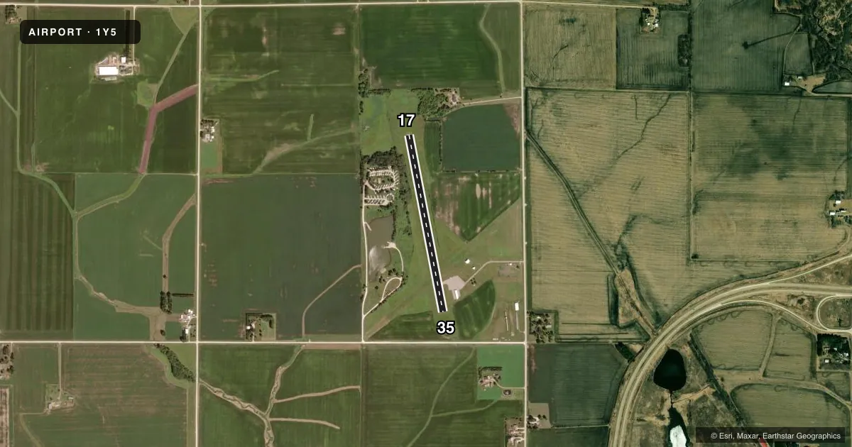
Airport sketch
Runways drawn to scale from FAA survey coordinates, rendered over satellite imagery. Not for navigation.
Approaches & charts
Services on the field
Fuel grades, oxygen, maintenance, ramp storage and lighting — as declared to the FAA by the airport operator.
Fuel & services
- Fuel
- Not available
- Oxygen (bottled)
- Not available
- Oxygen (bulk)
- Not available
- Airframe repair
- Not available
- Power plant repair
- Not available
Ramp & ground
- Transient storage
- Tie-down
- Landing fee
- No fee published
- Customs
- Not available
- Wind indicator
- Yes
- Segmented circle
- No
Fuel & FBOs
Cheapest 100LL and Jet A on the field and nearby. Always confirm with the FBO before taxi.
Airport notes
Surface conditions, obstructions, local procedures, lighting outages and other notes published with each FAA cycle.
General notes
- RC ACFT OPNS IN AREA.
- RWY 17 IS CALM WIND RWY.
- ARPT CLSD FOR NIGHT OPNS.
- FOR CD CTC DES MOINES APCH AT 515-974-8016. WHEN DES MOINES APP CLSD, FOR CD CTC MINNEAPOLIS ARTCC AT 651-463-5588.
- SNOW REMOVAL DELAYED AT TIMES; CONFIRM RWY COND PRIOR TO USE.
Approach & departure obstructions
- 04RYS 04 & 22 THLD & EDGES MARKED WITH YELLOW CONES.
Other notes
- MANAGERARPT COMM.
VFR map & nearby airports
VFR sectional. Tap any ICAO chip to open that airport.
Key facts · 1Y5
Answer card- ICAO
- 1Y5
- Name
- NEW HAMPTON MUNI
- Location
- NEW HAMPTON, IOWA
- Elevation
- 1,173 ft MSL
- Traffic pattern altitude
- 2,173 ft MSL (1,000 AGL)
- Control tower
- Non-towered (use CTAF)
- Total runways
- 1
- Longest runway
- 17/35 · 2,900 ft
- Published ILS approaches
- 0
- Published frequencies
- 1
- Magnetic variation
- 3°
- Current flight rules
- VFR
- Current wind
- 260° at 4 kt
- Favored runway now
- RWY 35
New Hampton Muni sits in New Hampton, Iowa. Field elevation is 1,173 ft MSL. The airport has one runway. Runway 17/35 is 2,900 ft long and paved. There is no control tower. CTAF is 122.9. No ILS approaches are published here.
The pattern altitude is not published. Use the standard 1,000 ft AGL pattern for light piston traffic unless the current Chart Supplement or local guidance says otherwise. Runway 17 is listed as the calm wind runway. The airport is closed for night operations, so plan daytime arrivals and departures only. Published remarks also note that snow removal can be delayed at times. Check runway condition before you go if winter weather is in play.
There are no on-field FBOs listed in the facts. Plan on confirming services with the airport operator before arrival. The remarks also mention radio-controlled aircraft activity in the area. Give that some room if you are operating in the pattern. For clearances, contact Des Moines Approach at 515-974-8016. When Des Moines Approach is closed, clearance delivery goes through Minneapolis ARTCC at 651-463-5588. If you are unsure about current runway condition or any local restriction, verify it with the current FAA Chart Supplement before flying in.