METAR & TAF C17
C17 does not publish a METAR.
Showing the nearest reporting station: KCID (THE EASTERN IOWA) · 11.8 NM away. Conditions at C17 may differ.
METAR · KCID
Observed 12:52Z
KCID 271252Z 19007KT 8SM SCT095 BKN110 28/25 A2978 RMK AO2 SLP074 T02780250 PNO
- Wind
- 190° @ 7 kt
- Visibility
- 8 SM
- Temp / Dew
- 28°C / 25°C
- Altimeter
- 29.78 inHg
- Clouds
- BKN
- Density alt
- 2,801 ft
- Ceiling
- 11,000 ft AGL
- Rules
- VFR
Airport info & contacts
Manager on record, flight service, ARTCC, attendance schedule and pattern altitude — published by the FAA and refreshed every 28 days.
Location
- From city
- 3 NM E
- VFR sectional
- CHICAGO
- ARTCC
- ZAU · CHICAGO
- NOTAM facility
- FOD (NOTAM-D)
Airport manager
- Name
- JON MORRIS
- Phone
- 319-270-7273
- Address
- 890 BOLTON MANOR ROAD, SPRINGVILLE IA 52336
Flight service · Hours
- FSS FOD
- FORT DODGE1-800-WX-BRIEF
- Attendance
- ALL
Frequencies
Tap any row to copy the frequency to your clipboard.
Runways & pattern
Full pagePattern entry · RWY 17
LEFT TRAFFICRunway end performance
| End | TORA | TODA | ASDA | LDA | VGSI | Approach lights | Obstruction |
|---|---|---|---|---|---|---|---|
| 17 | — | — | — | — | — | — | 16', trees, 275' from thr, 44' R of cntrln, slope 4 |
Declared distances in feet. TORA = takeoff run available, TODA = takeoff distance, ASDA = accelerate-stop, LDA = landing distance.
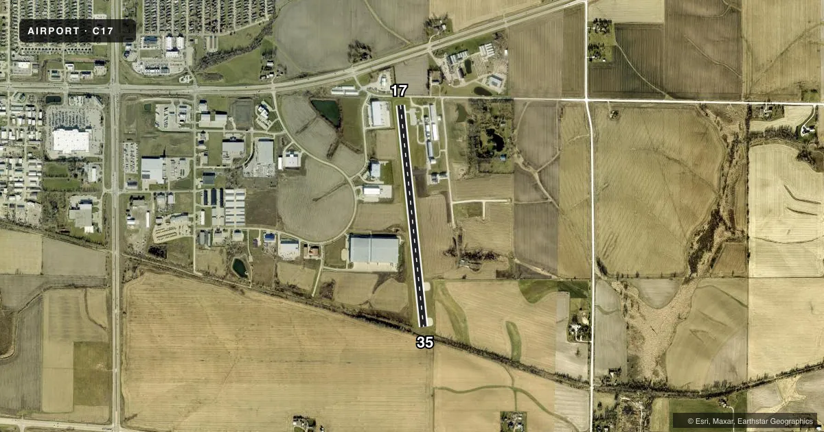
Airport sketch
Runways drawn to scale from FAA survey coordinates, rendered over satellite imagery. Not for navigation.
Approaches & charts
Services on the field
Fuel grades, oxygen, maintenance, ramp storage and lighting — as declared to the FAA by the airport operator.
Fuel & services
- Fuel
- 100LLAMOGAS
- Oxygen (bottled)
- Not available
- Oxygen (bulk)
- Not available
- Airframe repair
- Major
- Power plant repair
- Major
- Other services
- CHTR,INSTR,RNTL,SURV
Ramp & ground
- Transient storage
- Tie-down
- Hangar
- Landing fee
- No fee published
- Lighting schedule
- SS-SR
- Wind indicator
- Lighted
- Segmented circle
- No
Fuel & FBOs
Cheapest 100LL and Jet A on the field and nearby. Always confirm with the FBO before taxi.
Airport notes
Surface conditions, obstructions, local procedures, lighting outages and other notes published with each FAA cycle.
General notes
- DEER & WATERFOWL ON & INVOF ARPT.
- OCCASIONAL SKYDIVING AND BALLOON LAUNCHES MAY-SEP
- FOR CD CTC CHICAGO ARTCC AT 630-906-8921.
Approach & departure obstructions
- 17APCH SLOPE 20:1 TO DTHR.
- 1718 FT ROAD, 145 FT FM RWY END ON RWY CNTRLN.
Other notes
- ACTVT MIRL 17/35 - CTAF.
VFR map & nearby airports
VFR sectional. Tap any ICAO chip to open that airport.
Key facts · C17
Answer card- ICAO
- C17
- Name
- MARION
- Location
- MARION, IOWA
- Elevation
- 860.6 ft MSL
- Traffic pattern altitude
- 1,860.6 ft MSL (1,000 AGL)
- Control tower
- Non-towered (use CTAF)
- Total runways
- 1
- Longest runway
- 17/35 · 3,776 ft
- Published ILS approaches
- 0
- Published frequencies
- 4
- Magnetic variation
- 2°
- Current flight rules
- VFR
- Current wind
- 190° at 7 kt
- Favored runway now
- RWY 17
Marion Airport (C17) is in Marion, Iowa. The field elevation is 860.6 ft MSL. It has one runway, 17/35, which is 3,776 ft long and asphalt. There is no control tower. Pattern altitude is not published, so use the standard 1,000 ft AGL for light piston ops unless the current Chart Supplement says otherwise.
No ILS approaches are published here. CTAF and UNICOM are both 122.7. Cedar Rapids approach and departure are on 134.05 and 266.8. For clearance delivery, contact Chicago ARTCC at 630-906-8921. The runway lights on 17/35 are medium intensity. They are activated by the CTAF.
LuxAir Aviation is on the field. It carries 100LL, Jet A and mogas. Call (319) 377-1111 for current services before you go. Published remarks also note a road near the departure end of runway 17 on the centerline. They also note a steep approach slope to the runway 17 decision height. Deer and waterfowl are reported on and near the airport. Skydiving and balloon launches also occur from May through September, so expect extra traffic in that season.