METAR & TAF KAEL
Current METAR
Observed 10:15Z
KAEL 141015Z AUTO 31007KT 10SM OVC043 14/10 A2996 RMK AO2 T01360102
- Wind
- 310° @ 7 kt
- Visibility
- 10 SM
- Temp / Dew
- 14°C / 10°C
- Altimeter
- 29.96 inHg
- Clouds
- OVC
- Density alt
- 1,394 ft
- Ceiling
- 4,300 ft AGL
- Rules
- VFR
Airport info & contacts
Manager on record, flight service, ARTCC, attendance schedule and pattern altitude — published by the FAA and refreshed every 28 days.
Location
- From city
- 3 NM N
- VFR sectional
- OMAHA
- Pattern altitude
- 740 ft AGL · 2,001 ft MSL
- ARTCC
- ZMP · MINNEAPOLIS
- NOTAM facility
- AEL (NOTAM-D)
Airport manager
- Name
- JIM HANSON
- Phone
- 507-373-0608
- Address
- 73950 275TH ST., CLARKS GROVE MN 56016
Flight service · Hours
- FSS PNM
- PRINCETON1-800-WX-BRIEF
- Attendance
- 0800-1700
Frequencies
Tap any row to copy the frequency to your clipboard.
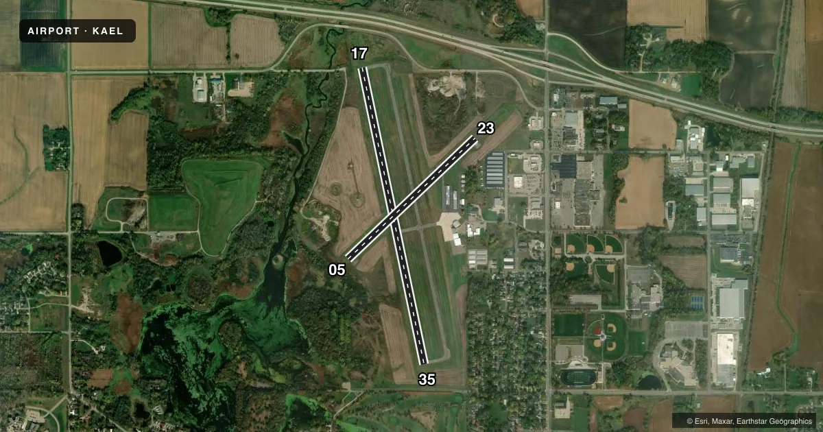
Runways & pattern
Full pagePattern entry · RWY 35
LEFT TRAFFIC| Runway | Heading (°M) | Length | Surface | Traffic |
|---|---|---|---|---|
| 17/35Favored | 167° / 347° | 5,000 ft | ASPH | Standard L |
| 05/23 | 46° / 226° | 2,898 ft | ASPH | Standard L |
Runway end performance
| End | TORA | TODA | ASDA | LDA | VGSI | Approach lights | Obstruction |
|---|---|---|---|---|---|---|---|
| 17 | — | — | — | — | PAPI 4-box left(3°) | ODALS | — |
| 35 | — | — | — | — | PAPI 4-box left(3°) | — | 7', road, 332' from thr, 499' R of cntrln, slope 18 |
Declared distances in feet. TORA = takeoff run available, TODA = takeoff distance, ASDA = accelerate-stop, LDA = landing distance.
Airport sketch
Runways drawn to scale from FAA survey coordinates, rendered over satellite imagery. Not for navigation.
Approaches & charts
Services on the field
Fuel grades, oxygen, maintenance, ramp storage and lighting — as declared to the FAA by the airport operator.
Fuel & services
- Fuel
- 100LLAMOGAS
- Oxygen (bottled)
- Not available
- Oxygen (bulk)
- Not available
- Airframe repair
- Minor
- Power plant repair
- Minor
- Other services
- INSTR,RNTL,SALES
Ramp & ground
- Transient storage
- Tie-down
- Hangar
- Landing fee
- Yes
- Customs
- Not available
- Lighting schedule
- SEE RMK
- Beacon schedule
- SS-SR
- Beacon
- White / Green (civil land)(WG)
- Wind indicator
- Lighted
- Segmented circle
- No
Fuel & FBOs
Cheapest 100LL and Jet A on the field and nearby. Always confirm with the FBO before taxi.
Airport notes
Surface conditions, obstructions, local procedures, lighting outages and other notes published with each FAA cycle.
General notes
- TV TWR 9.5 NM SE.
- GLIDERS & HELICOPTERS USE TURF PARALLEL TO RY 17/35 ON EAST SIDE & APPR AREA TO RY 23.
- MULTIPLE TRANSITIONAL OBSTNS RY 05 & RY 35.
- FOR CD CTC ROCHESTER APCH AT 507-424-8111.
Lighting notes
- ACTVT ODALS RWY 17; REIL RWY 17 & 35; PAPI RWY 17 & 35; MIRL RWY 17/35 - CTAF. MIRL RWY 17/35 PRESET TO LOW SS-SR TO INCR INTST - CTAF.
Fuel notes
- 100LL100LL & MOGAS FUEL AVBL 24 HR WITH CREDIT CARD.
Approach & departure obstructions
- 05RWY 05 HAS 5 FT BRUSH 79 FT FM THE RWY END AND 79 FT RIGHT.
Other notes
- TIE DOWN FEE WAVED WITH FUEL PURCHASE.
- 1FOR SVC AFT HRS CALL 507-826-3451.
- MANAGEREMAIL ADDRESS: JIMHANSON@DESKMEDIA.COM (ALL LOWER CASE)
VFR map & nearby airports
VFR sectional. Tap any ICAO chip to open that airport.
Key facts · KAEL
Answer card- ICAO
- KAEL
- Name
- ALBERT LEA MUNI
- Location
- ALBERT LEA, MINNESOTA
- Elevation
- 1,261 ft MSL
- Traffic pattern altitude
- 2,001 ft MSL (740 AGL)
- Control tower
- Non-towered (use CTAF)
- Total runways
- 2
- Longest runway
- 17/35 · 5,000 ft
- Published ILS approaches
- 0
- Published frequencies
- 4
- Magnetic variation
- 1°
- Current flight rules
- VFR
- Current wind
- 310° at 7 kt
- Favored runway now
- RWY 35
Albert Lea Muni sits in Albert Lea, Minnesota. The field elevation is 1,261 ft MSL. It has two asphalt runways. The longest is 5,000 ft on 17/35. The airport is non-towered, so CTAF work matters here. Pattern altitude is 740 ft AGL, which is 2,001 ft MSL. No ILS approaches are published.
For clearance delivery, Rochester Approach handles it by phone. The approach frequencies listed are 119.8 and 251.125. The on-field FBO is Albert Lea Municipal Airport. It carries 100LL, Jet A Prist and mogas. 100LL and mogas are available 24 hours with credit card. Tie-down fee is waived with fuel purchase.
A first-time pilot should pay attention to the runway environment. Runway 05 has a brush obstruction near the end on the right side. The remarks also call out multiple transitional obstructions on runway 05 and runway 35. Gliders and helicopters use turf areas east of runway 17/35 and the approach area to runway 23. Runway 17 has ODALS, REILs, PAPI and medium intensity runway lights. The medium intensity lights on 17/35 are CTAF controlled and preset low from sunset to sunrise. The field is in southern Minnesota. Check current weather and performance carefully before arrival.