METAR & TAF KOWA
Current METAR
Observed 18:55Z
KOWA 271855Z AUTO 30012G17KT 10SM CLR 31/24 A2974 RMK AO2 T03140241
- Wind
- 300° @ 12G17 kt
- Visibility
- 10 SM
- Temp / Dew
- 31°C / 24°C
- Altimeter
- 29.74 inHg
- Clouds
- CLR
- Density alt
- 3,563 ft
- Ceiling
- Unlimited
- Rules
- VFR
Airport info & contacts
Manager on record, flight service, ARTCC, attendance schedule and pattern altitude — published by the FAA and refreshed every 28 days.
Location
- From city
- 3 NM NW
- VFR sectional
- OMAHA
- Pattern altitude
- 852 ft AGL · 1,997 ft MSL
- ARTCC
- ZMP · MINNEAPOLIS
- NOTAM facility
- OWA (NOTAM-D)
Airport manager
- Name
- DAVE BEAVER
- Phone
- 507-774-7141
- Address
- 3400 W FRONTAGE RD, OWATONNA MN 55060-5660
Flight service · Hours
- FSS PNM
- PRINCETON1-800-WX-BRIEF
- Attendance
- MAY-SEP · MON-FRI · 0800-1700
- MAY-SEP · SAT-SUN · 1000-1600
- OCT-APR · MON-FRI · 0800-1700
- OCT-APR · SAT-SUN · 1100-1500
Frequencies
Tap any row to copy the frequency to your clipboard.
Runways & pattern
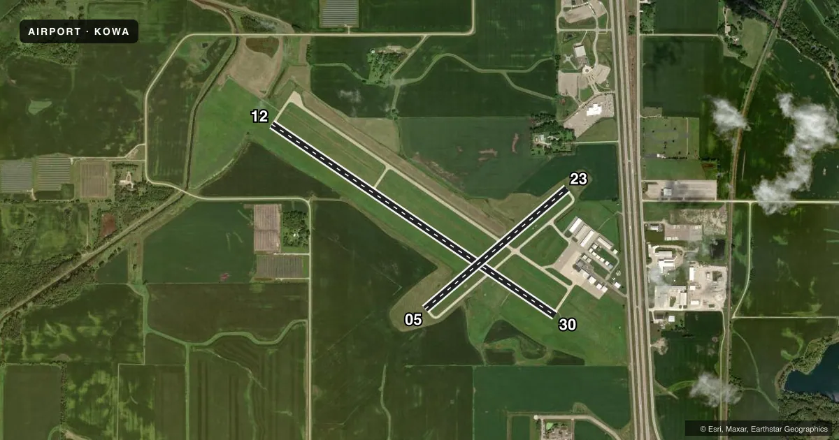
Full pagePattern entry · RWY 30
LEFT TRAFFIC| Runway | Heading (°M) | Length | Surface | Traffic |
|---|---|---|---|---|
| 12/30Favored | 122° / 302° | 5,500 ft | CONC | Standard L |
| 05/23 | 48° / 228° | 3,000 ft | ASPH | Standard L |
Runway end performance
| End | TORA | TODA | ASDA | LDA | VGSI | Approach lights | Obstruction |
|---|---|---|---|---|---|---|---|
| 12 | — | — | — | — | PAPI 4-box left(3°) | — | — |
| 30 | — | — | — | — | PAPI 4-box left(3°) | MALSR | sign, slope 50 |
| 05 | — | — | — | — | PAPI 4-box left(3°) | — | — |
| 23 | — | — | — | — | PAPI 4-box left(3°) | — | — |
Declared distances in feet. TORA = takeoff run available, TODA = takeoff distance, ASDA = accelerate-stop, LDA = landing distance.
Airport sketch
Runways drawn to scale from FAA survey coordinates, rendered over satellite imagery. Not for navigation.
Approaches & charts
ILS · 1
Services on the field
Fuel grades, oxygen, maintenance, ramp storage and lighting — as declared to the FAA by the airport operator.
Fuel & services
- Fuel
- 100LLA
- Oxygen (bottled)
- Not available
- Oxygen (bulk)
- Not available
- Airframe repair
- Major
- Power plant repair
- Major
- Other services
- INSTR,RNTL,SALES
Ramp & ground
- Transient storage
- Tie-down
- Hangar
- Landing fee
- No fee published
- Customs
- Not available
- Lighting schedule
- SEE RMK
- Beacon schedule
- SS-SR
- Beacon
- White / Green (civil land)(WG)
- Wind indicator
- Lighted
- Segmented circle
- No
Fuel & FBOs
Cheapest 100LL and Jet A on the field and nearby. Always confirm with the FBO before taxi.
Airport notes
Surface conditions, obstructions, local procedures, lighting outages and other notes published with each FAA cycle.
General notes
- ULTRALIGHTS ON AND INVOF ARPT.
- FOR CD CTC ROCHESTER APCH AT 507-424-8111.
Lighting notes
- ACTVT MIRL RY 05/23; MALSR RY 30; REIL RY 05, 12 & 23; HIRL RY 12/30; PAPI RY 05, 12, 23, & 30 - CTAF.
Fuel notes
- 100LL100LL AVBL 24 HRS W CREDIT CARD.
- AJET A AFT HRS 507-774-7141.
VFR map & nearby airports
VFR sectional. Tap any ICAO chip to open that airport.
Key facts · KOWA
Answer card- ICAO
- KOWA
- Name
- OWATONNA DEGNER RGNL
- Location
- OWATONNA, MINNESOTA
- Elevation
- 1,145.4 ft MSL
- Traffic pattern altitude
- 1,997.4 ft MSL (852 AGL)
- Control tower
- Non-towered (use CTAF)
- Total runways
- 2
- Longest runway
- 12/30 · 5,500 ft
- Published ILS approaches
- 1
- Published frequencies
- 4
- Magnetic variation
- 2°
- Current flight rules
- VFR
- Current wind
- 300° at 12 kt
- Favored runway now
- RWY 30
Owatonna Degner Rgnl Airport is in Owatonna, Minnesota. Field elevation is 1,145.4 ft MSL. The airport has two runways. The longest is runway 12/30 at 5,500 ft. There is no control tower. For clearance delivery, Rochester Approach handles it. The published pattern altitude is 852 ft AGL, which is 1,997.4 ft MSL.
Runway 30 has the ILS approach. The field also has medium intensity runway lights on 05/23, high intensity runway lights on 12/30 and runway end identifier lights on 05, 12, 23 and 30. Precision approach path indicators are published on all runway ends and operate on CTAF. That helps for night work and for getting stabilized on final.
Southern Minnesota Flight Center is on the field. It carries 100LL and Jet A. 100LL is available 24 hours with credit card. Jet A is available after hours by calling the number in the Chart Supplement. Ultralight aircraft also operate on and near the airport. Keep a sharp scan in the pattern and on taxi. First-time visitors should also note the airport sits in southern Minnesota with no tower. Use standard self-announce discipline and verify current procedures with Rochester Approach or the airport operator before arrival.